imagens da terra como tudo começou? - professores.uff.br · 21 de outubro de 2003 concepção...
TRANSCRIPT

Imagens da TerraImagens da TerraComo tudo comeComo tudo começçou?ou?

Imagem que ficou consagrada como a origem da fotografia só foi obtida por Nièpce em 1826.

O vôo de Nadar (Tournachon) em balão
sobre Paris em 1858
Em 1849, o Coronel AiméLaussedat, um oficial do exército
francês, utilizou um sistema fotográfico desenvolvido por
Daguerre embarcado em um balão para obter fotos cuja finalidade era
o mapeamento topográfico.

Ballon observing the battle of AnteitamFonte: http://americancivilwar.com/pictures/
Primeiro corpo de balonista de um exército.Guerra Civil americana - 1862

Uma câmara desenvolvida e patenteada por Julius Neubronner em 1903 cuja particularidade era de ser acoplada a um pombo, pois pesava apenas 70 g.
câmara acoplada a um pombo
Fonte: http://www.esteio.com.br/newsletters/paginas/002/o-historico.htm/

Uso intenso de fotografias aéreas durante as I e II Guerras Mundiais, para o reconhecimento, detecção de posições inimigas e estratégia militar como um todo.

Fonte: web.umr.edu/~rogersda/ umrcourses/ge342/
The First World War (1914-18) marked the transition between beasts-of-burdenand mechanical vehicles providing the lion’s share of logistic support, though
not always successfully.

America invented what is now called the U2. The U2 flew at altitudes high enoughto avoid radar detection and Soviet missiles. This worked until Soviet technology
became improved enough to have radar that could locate and shoot down anairplane at high altitudes

History changed on October 4, 1957, when the Soviet Union successfullylaunched Sputnik I. The world's first
artificial satellite
The satellite was silver in color, about the size of a beach ball, andweighed a mere 184 pounds. Yetfor all its simplicity, small size, andinability to do more than orbit theEarth and transmit meaninglessradio blips, the impact of Sputnik
on the United States and the worldwas enormous and unprecedented.

View of the launch of Mercury-Atlas 4 spacecraft from Cape Canaveral on
Sept. 13, 1961.

CORONA was America's first operational spacereconnaissance project. Its first successful
mission was on August 18, 1960, and it operated for almost twelve years during the
Cold War.

Renamed Landsat, ERTS-1 was the first in this
series (seven to date) of Earth-observing satellites
that have permittedcontinuous coverage of most of Earth's surface
since 1972.

Lançamento do CBERS-2 em 21 de Outubro de 2003
Concepção Artística do CBERS-2em Órbita

Imagens da TerraImagens da Terra
CaracterCaracteríísticassticas

SPOT - Maciço da Tijuca1991
Banda 1 - Verde
Banda 2 - Vermelha
Banda 3 - Infra-Vermelha
ResoluResoluçção Espectralão Espectral

Geostationary Operational Environmental Satellites - GOESResolução espacial 1 a 8 kmResolução temporal 30 min
ResoluResoluçção ão Espacial Espacial
TemporalTemporal
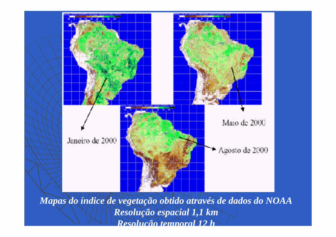
Mapas do índice de vegetação obtido através de dados do NOAAResolução espacial 1,1 kmResolução temporal 12 h

IKONOS 1- Enseada da Glória -Resolução espacial 1 m
Resolução temporal 3 a 5 dias
SPOT 4 - Enseada da Glória -Resolução 20 m
Resolução temporal 26 diasoff nadir – 1 a 4 dias

SPOT 4
ResoluResoluçção Temporalão Temporal

Imagens da TerraImagens da TerraAplicaAplicaççõesões

Monitoramento ambientalMonitoramento ambiental

Inserir acidente na da petrobras na BG

SPOT - 1991 SPOT - 1997

This scene shows an area due east of Porto Velho, the capital of the Brazilian state of Rondonia in northwest Brazil, along the Brazilian and Bolivian border. A section
of Highway BR-364 and the Jamari River bisect the tropical rain forest. SPOT. 1992

This satellite image shows the central part of Bangladesh. The Meghna River flows southward towards its confluence with the
Ganges River,
This satellite image shows the central part of Bangladesh. The Meghna River flows southward towards its confluence with the
Ganges River
SPOT. 1988

IKONOS -Bacia de Campos, Plataforma P34
Acidentes Acidentes

Mount Sakura-Jima is an active volcano at the very southern tip of Japan. It is located in the middle of Kagoshima Bay, with a narrow piece of land linking it
to the mainland. SPOT. 1986.

Cidade turística de Kalutara, no Sri Lanka- Cena obtida algumas horas após, o recuo do mar é nítido. Após invadir a cidade com ondas de até 10 metros de altura, as águas retornaram com a mesma intensidade rumo ao mar, deixando descoberto
pelo menos 150 metros de praia. QUICKBIRD

Cidade de Banda Aceh, na região norte da ilha de Sumatra 23 de junho/2004

Cidade de Banda Aceh, na região norte da ilha de Sumatra 28 de dez/2004

IKONOS - Itaipu
Projetos de Engenharia Projetos de Engenharia

Atividade AgrAtividade Agríícola cola
Pivots de irrigação na região de Andaraí - BA Ikonos PSM Nível Carterra Geo1m de resolução

LANDSAT 7 - Angra dos Reis2000
Estudos de temperaturaEstudos de temperatura

Modelo Digital de TerrenoModelo Digital de Terreno
Guaratuba - IKONOS

SPOT 5 - Santiago
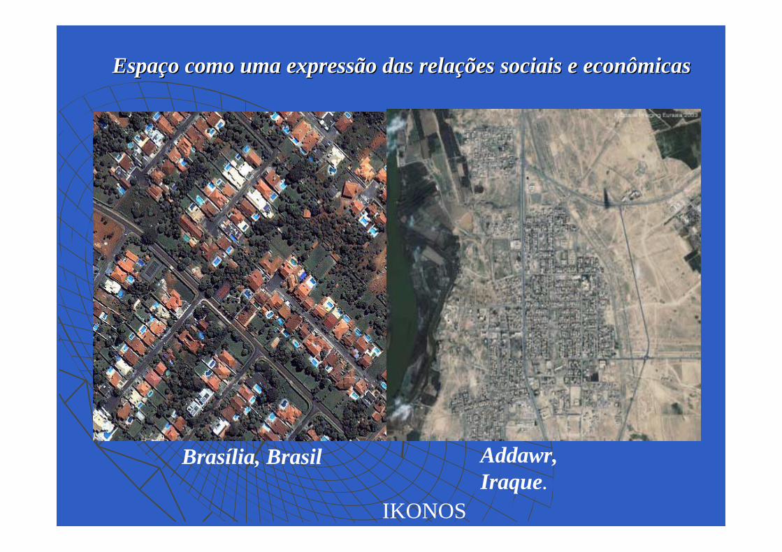
EspaEspaçço como uma expressão das relao como uma expressão das relaçções sociais e econômicasões sociais e econômicas
Brasília, Brasil Addawr, Iraque.
IKONOS

Servindo para fazer a GuerraServindo para fazer a Guerra

IKONOSWorld Trade Center - setembro/2001

IKONOS - Pentágono - 2001


(1) Tucson, AZ/AspenForest Fire Application
(Bands 197-107-18)
(2) India, Brahmaputra RiverFlood Applicaiton(Bands 50-23-16)
(1) (2)
EOS-1 Hyperion30 m