eixo temático: sensoriamento remoto -...
TRANSCRIPT
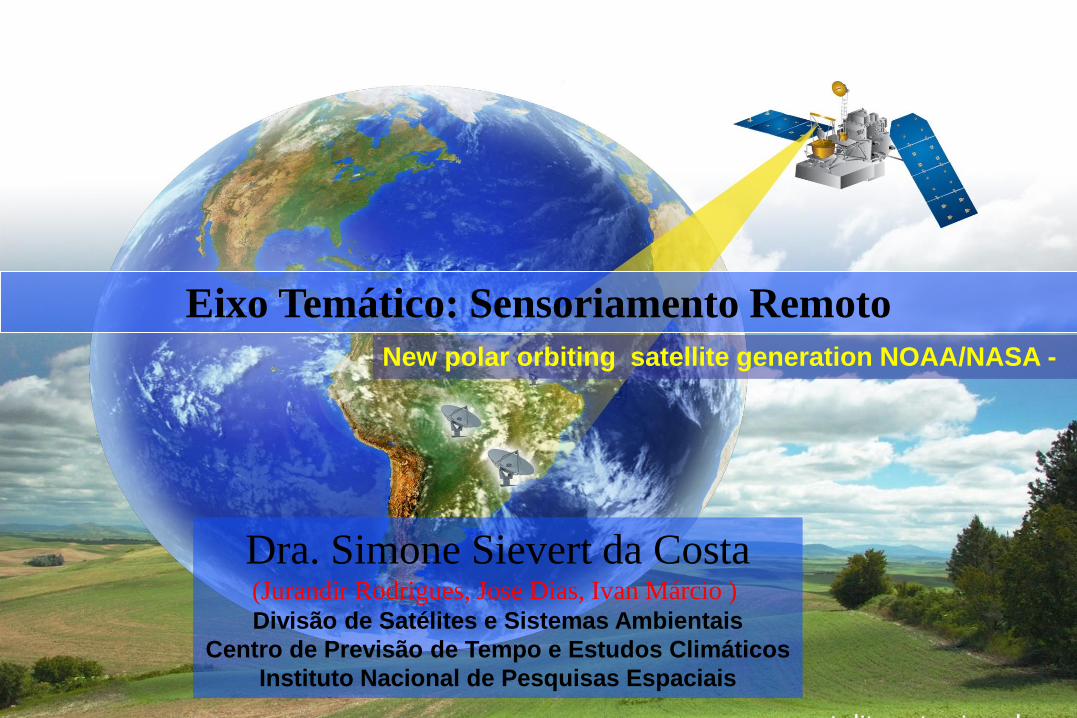
New polar orbiting satellite generation NOAA/NASA -
Eixo Temático: Sensoriamento Remoto
Dra. Simone Sievert da Costa(Jurandir Rodrigues, Jose Dias, Ivan Márcio ) Divisão de Satélites e Sistemas Ambientais
Centro de Previsão de Tempo e Estudos Climáticos
Instituto Nacional de Pesquisas Espaciais
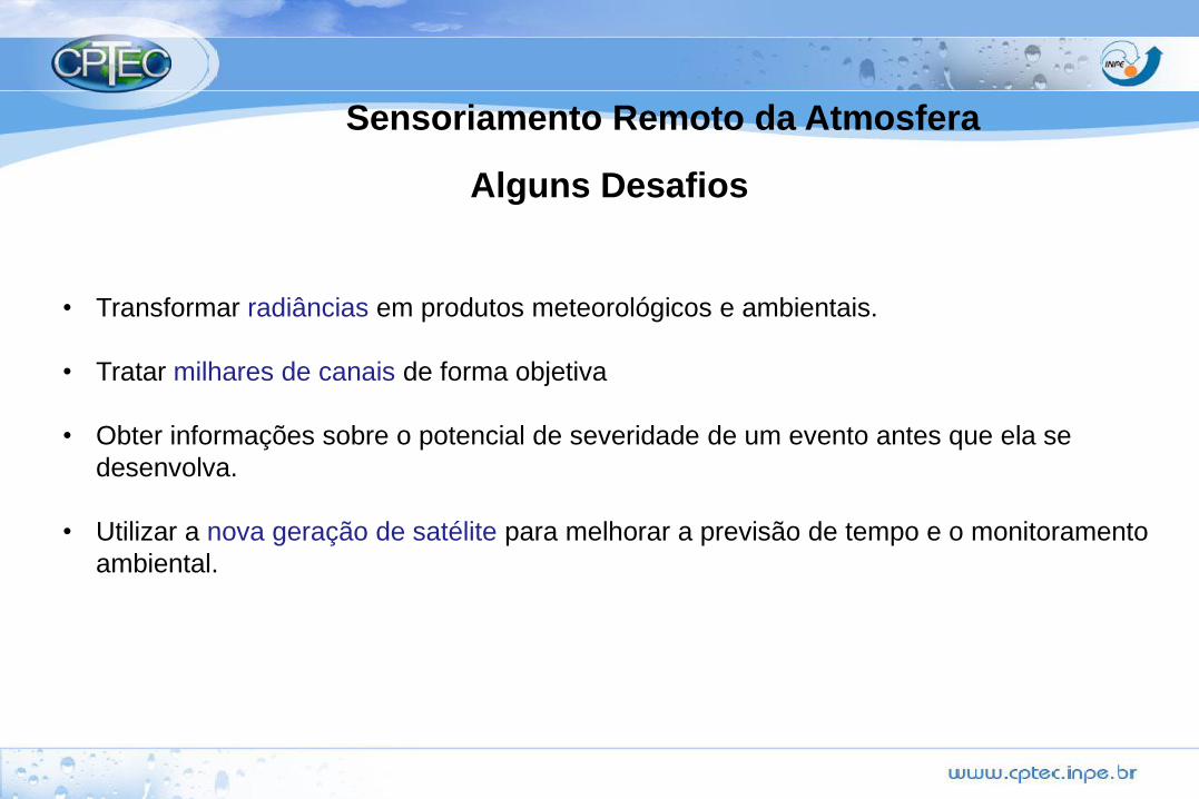
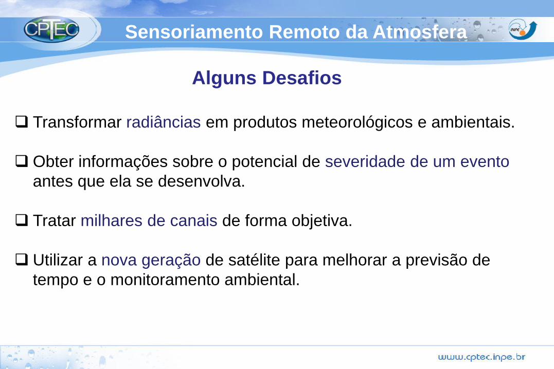
Sensoriamento Remoto da Atmosfera
Alguns Desafios
• Transformar radiâncias em produtos meteorológicos e ambientais.
• Tratar milhares de canais de forma objetiva
• Obter informações sobre o potencial de severidade de um evento antes que ela se
desenvolva.
• Utilizar a nova geração de satélite para melhorar a previsão de tempo e o monitoramento
ambiental.
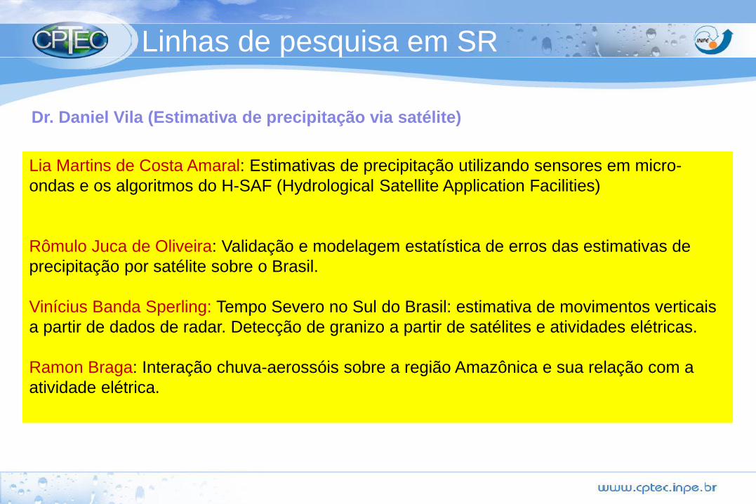
Lia Martins de Costa Amaral: Estimativas de precipitação utilizando sensores em micro-
ondas e os algoritmos do H-SAF (Hydrological Satellite Application Facilities)
Rômulo Juca de Oliveira: Validação e modelagem estatística de erros das estimativas de
precipitação por satélite sobre o Brasil.
Vinícius Banda Sperling: Tempo Severo no Sul do Brasil: estimativa de movimentos verticais
a partir de dados de radar. Detecção de granizo a partir de satélites e atividades elétricas.
Ramon Braga: Interação chuva-aerossóis sobre a região Amazônica e sua relação com a
atividade elétrica.
Dr. Daniel Vila (Estimativa de precipitação via satélite)
Linhas de pesquisa em SR
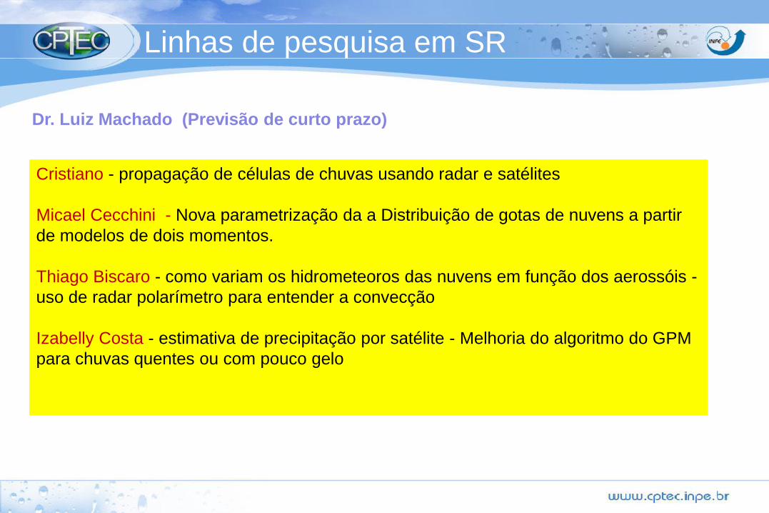
Cristiano - propagação de células de chuvas usando radar e satélites
Micael Cecchini - Nova parametrização da a Distribuição de gotas de nuvens a partir
de modelos de dois momentos.
Thiago Biscaro - como variam os hidrometeoros das nuvens em função dos aerossóis -
uso de radar polarímetro para entender a convecção
Izabelly Costa - estimativa de precipitação por satélite - Melhoria do algoritmo do GPM
para chuvas quentes ou com pouco gelo
Dr. Luiz Machado (Previsão de curto prazo)
Linhas de pesquisa em SR
Bruno Dos Santos Guimarães: Estudo dos Vórtices Ciclônicos de Altos Níveis utilizando o
canal do vapor d´água do imageador do satélite GOES.
Valesca
Marilia
Jéssica
Dr. Nelson (Meteorologia Física e por Satélite )
Linhas de pesquisa em SR
Anthony Silva: Estimativa de radiação solar à superfície e impactos do aerossol: uma
perpectiva no contexto do GOES-R
Francisco Mesquita: Balanço de radiação em condições de céu claro e com nuvens a partir
de dados de satélites. (GOES, MSG).
Hallan de Jesus: Impacto das nuvens na radiação solar UV. (GOES-R)
Nathalia Prado: Analise observacional da variabilidade espacial e temporal das propriedades
ópticas. (MODIS, S-NPP)
Nancy Rios: Adaptação da Parametrização de AOD para a América do Sul no âmbito da
Nova geração de satélites. (S-NPP e GOES-R)
Jose Dias: Validação física e experimental dos dados de AOD gerados no contexto S-NPP.
Dr. Juan Ceballos e Dra Simone Sievert (Estimativa de Radiação e Aerossóis via satélite )
Linhas de pesquisa em SR
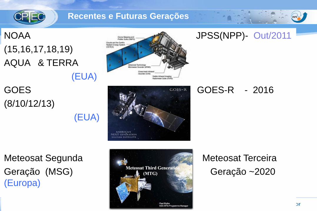
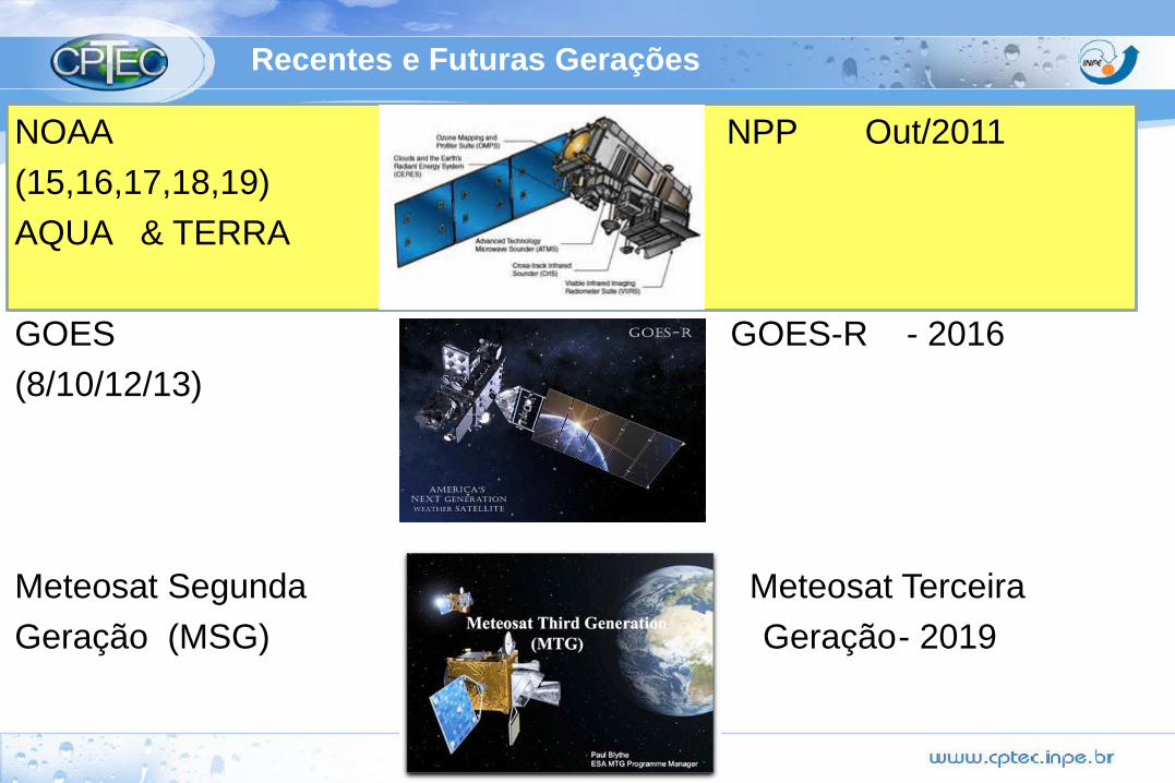
Recentes e Futuras Gerações
NOAA JPSS(NPP)- Out/2011
(15,16,17,18,19)
AQUA & TERRA
(EUA)
GOES GOES-R - 2016
(8/10/12/13)
(EUA)
Meteosat Segunda Meteosat Terceira
Geração (MSG) Geração ~2020
(Europa)
Recentes e Futuras Gerações
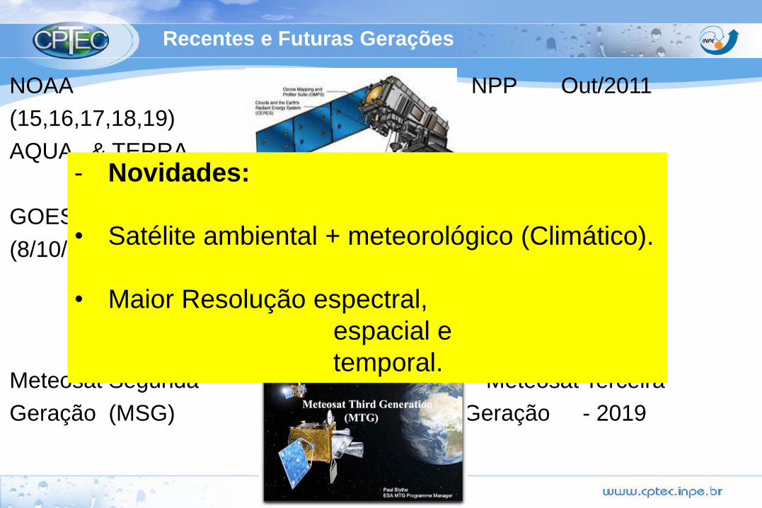
NOAA NPP Out/2011
(15,16,17,18,19)
AQUA & TERRA
GOES GOES-R - 2016
(8/10/12/13)
Meteosat Segunda Meteosat Terceira
Geração (MSG) Geração - 2019
- Novidades:
• Satélite ambiental + meteorológico (Climático).
• Maior Resolução espectral,
espacial e
temporal.
Recentes e Futuras Gerações
NOAA NPP Out/2011
(15,16,17,18,19)
AQUA & TERRA
GOES GOES-R - 2016
(8/10/12/13)
Meteosat Segunda Meteosat Terceira
Geração (MSG) Geração- 2019
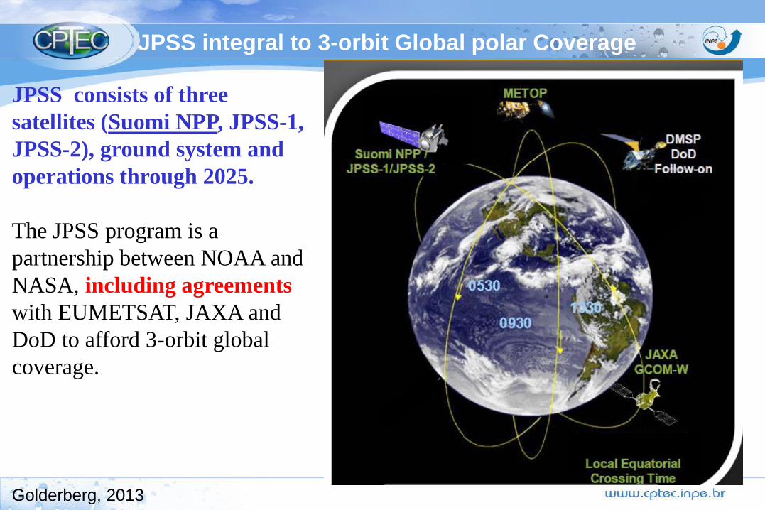
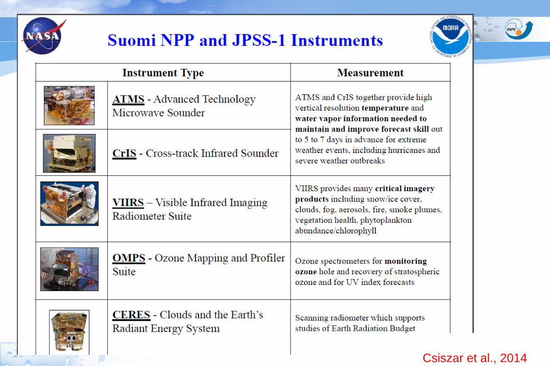
JPSS integral to 3-orbit Global polar Coverage
JPSS consists of three
satellites (Suomi NPP, JPSS-1,
JPSS-2), ground system and
operations through 2025.
The JPSS program is a
partnership between NOAA and
NASA, including agreements
with EUMETSAT, JAXA and
DoD to afford 3-orbit global
coverage.
Golderberg, 2013

First JPSS Satellite: Suomi - NPP
Nome: Suomi - National Polar-orbiting
Partnership (S-NPP).
Lançamento: Out. 2011
Orbita: 824 km
Tempo de vida: 5 anos
Volume de dados: 10 vezes > geração anterior da NOAA
Vern Suomi
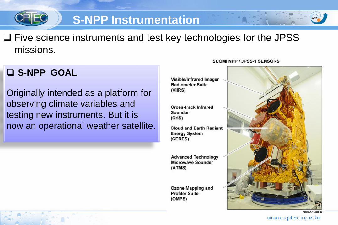
S-NPP Instrumentation
Furgerson, 2014
Five science instruments and test key technologies for the JPSS
missions.
S-NPP GOAL
Originally intended as a platform for
observing climate variables and
testing new instruments. But it is
now an operational weather satellite.
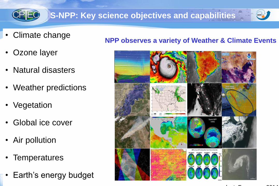
• Climate change
• Ozone layer
• Natural disasters
• Weather predictions
• Vegetation
• Global ice cover
• Air pollution
• Temperatures
• Earth’s energy budget
S-NPP: Key science objectives and capabilities
NPP observes a variety of Weather & Climate Events
adapt. Furgerson, 2014

The first complete global image from VIIRS.
November 24, 2011
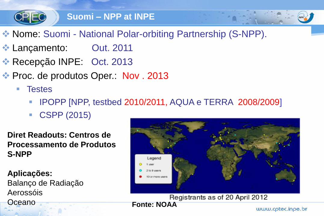
Suomi – NPP at INPE
Nome: Suomi - National Polar-orbiting Partnership (S-NPP).
Lançamento: Out. 2011
Recepção INPE: Oct. 2013
Proc. de produtos Oper.: Nov . 2013
Testes
IPOPP [NPP, testbed 2010/2011, AQUA e TERRA 2008/2009]
CSPP (2015)
Diret Readouts: Centros de
Processamento de Produtos
S-NPP
Aplicações:
Balanço de Radiação
Aerossóis
Oceano Fonte: NOAA
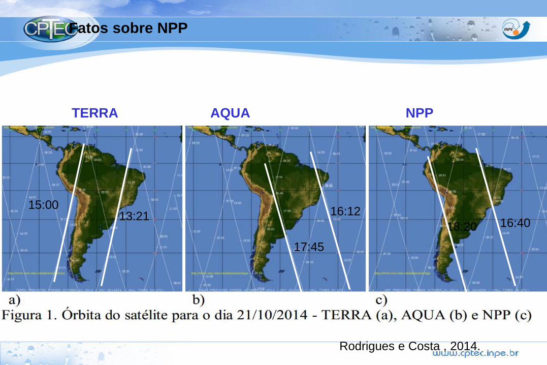
Fatos sobre NPP
16:4016:12
18:20
17:45
13:2115:00
TERRA AQUA NPP
Rodrigues e Costa , 2014.
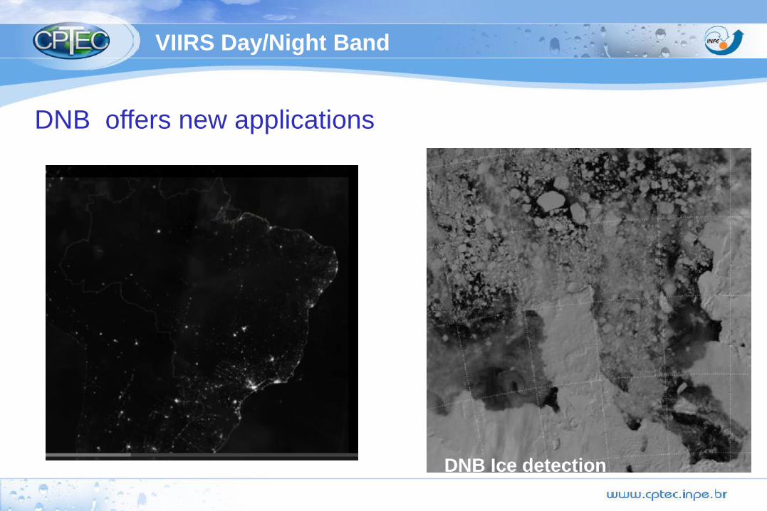
DNB offers new applications
DNB Ice detection
VIIRS Day/Night Band
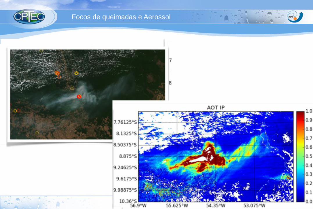
Focos de queimadas e Aerossol
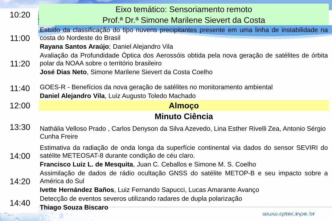
10:20Eixo temático: Sensoriamento remoto
Prof.ª Dr.ª Simone Marilene Sievert da Costa
11:00Estudo da classificação do tipo nuvens precipitantes presente em uma linha de instabilidade na
costa do Nordeste do Brasil
Rayana Santos Araújo; Daniel Alejandro Vila
11:20Avaliação da Profundidade Óptica dos Aerossóis obtida pela nova geração de satélites de órbita
polar da NOAA sobre o território brasileiro
José Dias Neto, Simone Marilene Sievert da Costa Coelho
11:40 GOES-R - Benefícios da nova geração de satélites no monitoramento ambiental
Daniel Alejandro Vila, Luiz Augusto Toledo Machado
12:00 Almoço
13:30
Minuto Ciência
Nathália Velloso Prado , Carlos Denyson da Silva Azevedo, Lina Esther Rivelli Zea, Antonio Sérgio
Cunha Freire
14:00Estimativa da radiação de onda longa da superfície continental via dados do sensor SEVIRI do
satélite METEOSAT-8 durante condição de céu claro.
Francisco Luiz L. de Mesquita, Juan C. Ceballos e Simone M. S. Coelho
14:20Assimilação de dados de rádio ocultação GNSS do satélite METOP-B e seu impacto sobre a
América do Sul
Ivette Hernández Baños, Luiz Fernando Sapucci, Lucas Amarante Avanço
14:40Detecção de eventos severos utilizando radares de dupla polarização
Thiago Souza Biscaro
The content presented here is base on different sources:
Visible night
https://www.meted.ucar.edu/satmet/dnb/
http://npp.gsfc.nasa.gov/atms.html
Conferencia CSPP
http://www.ssec.wisc.edu/meetings/cspp/2013/presentations/
JPSS
http://www.jpss.noaa.gov/igarss-2014.html
NOAA JPSS
http://www.jpss.noaa.gov/
NOAA STAR
http://www.star.nesdis.noaa.gov/jpss/
•STAR JPSS 2014 Annual Science Team Meeting
http://www.star.nesdis.noaa.gov/star/meeting_2014JPSSAnnual_agenda.php
Further information
:
Conclusão:
• Somente satélites podem:
• Monitorar a evolução do ciclo de vida de sistema de tempo
(RADAR)
• Realizar análise global e assimilação de dados.
• Coletar dados em todo o globo -> intercomparar regiões com o
mesmo sensor.
• Obter grande cobertura de dados em tempo real integrado em
uma única plataforma.
• Observar diversas informações sobre a atmosfera devido a
capacidade de resolução temporal, espacial e espectral.
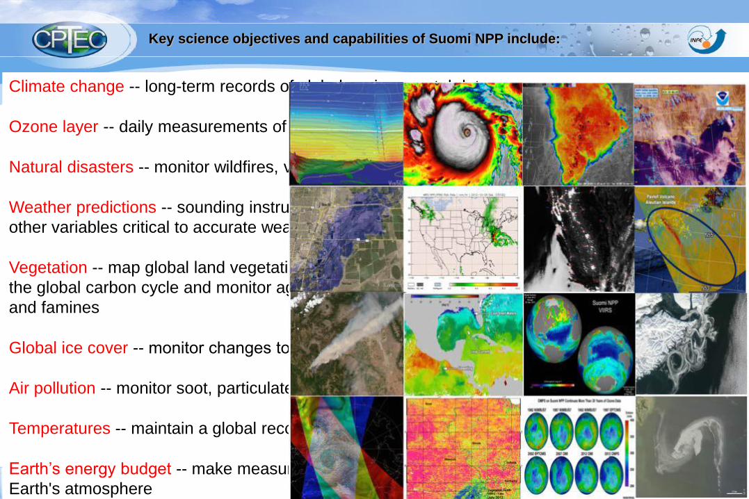
Climate change -- long-term records of global environmental data
Ozone layer -- daily measurements of the atmospheric ozone layer
Natural disasters -- monitor wildfires, volcanic eruptions, snowstorms, droughts, floods, hurricanes.
Weather predictions -- sounding instrument (cloud cover, atmospheric temperatures, humidity and
other variables critical to accurate weather prediction)
Vegetation -- map global land vegetation and quantify changes in plant productivity to understand
the global carbon cycle and monitor agricultural processes to predict and respond to food shortages
and famines
Global ice cover -- monitor changes to Earth’s sea ice, land ice and glaciers
Air pollution -- monitor soot, particulate matter, nitrogen dioxide and sulfur dioxide.
Temperatures -- maintain a global record of atmospheric, land surface and sea surface temperatures
Earth’s energy budget -- make measurements to determine how much energy is entering and exiting
Earth's atmosphere
Key science objectives and capabilities of Suomi NPP include:
VIIRS data will be used to expand upon the
MODIS applications to fire and air quality
monitoring, agriculture monitoring and
production modeling, carbon modeling and flood
and sea ice mapping.
Csiszar et al., 2014
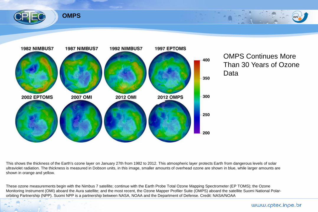
OMPS
This shows the thickness of the Earth's ozone layer on January 27th from 1982 to 2012. This atmospheric layer protects Earth from dangerous levels of solar
ultraviolet radiation. The thickness is measured in Dobson units, in this image, smaller amounts of overhead ozone are shown in blue, while larger amounts are
shown in orange and yellow.
These ozone measurements begin with the Nimbus 7 satellite; continue with the Earth Probe Total Ozone Mapping Spectrometer (EP TOMS); the Ozone
Monitoring Instrument (OMI) aboard the Aura satellite; and the most recent, the Ozone Mapper Profiler Suite (OMPS) aboard the satellite Suomi National Polar-
orbiting Partnership (NPP). Suomi NPP is a partnership between NASA, NOAA and the Department of Defense. Credit: NASA/NOAA
OMPS Continues More
Than 30 Years of Ozone
Data
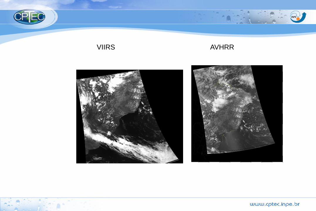
VIIRS AVHRR
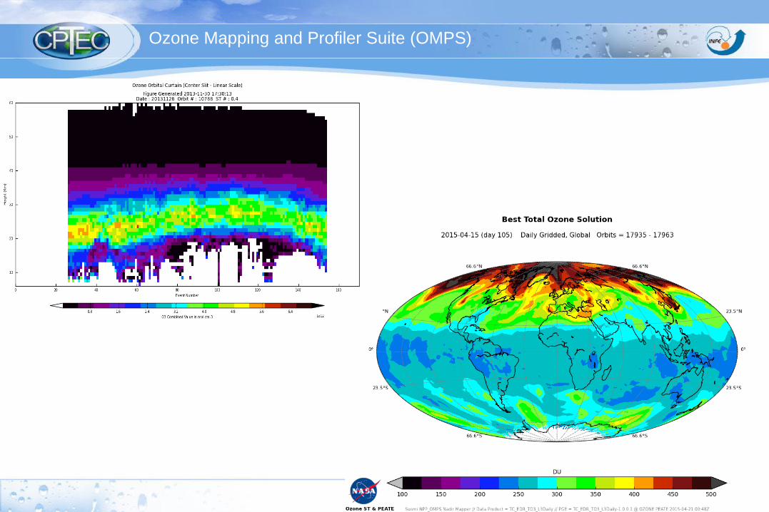
Ozone Mapping and Profiler Suite (OMPS)
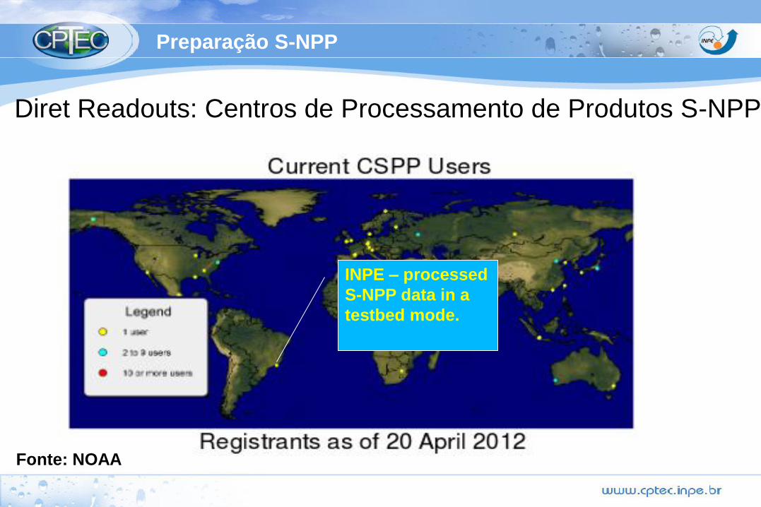
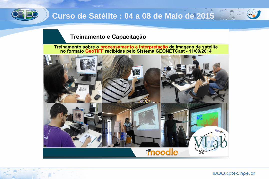
Preparação S-NPP
Diret Readouts: Centros de Processamento de Produtos S-NPP
Fonte: NOAA
INPE – processed
S-NPP data in a
testbed mode.
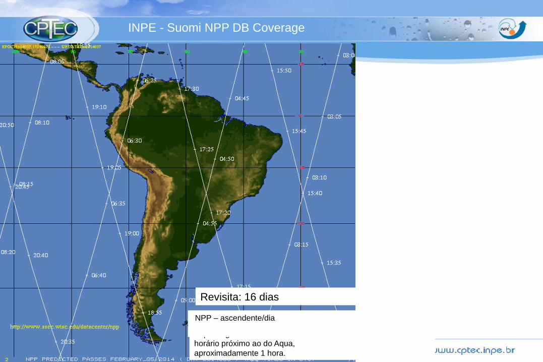
INPE - Suomi NPP DB Coverage
Revisita: 16 dias
A passagem do NPP tem o
horário próximo ao do Aqua,
aproximadamente 1 hora.
NPP – ascendente/dia
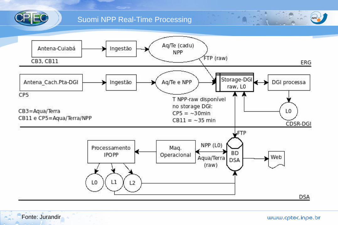
Suomi NPP Real-Time Processing
IPOPP
CSPP
Fonte: Jurandir
35

Preparação S-NPP
Diret Readouts: Centros de Processamento de Produtos S-NPP
Fonte: NOAA
INPE – processed
S-NPP data in a
testbed mode.

NPP Algorithm
Maturity
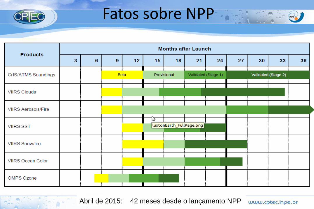
Fatos sobre NPP
Abril de 2015: 42 meses desde o lançamento NPP
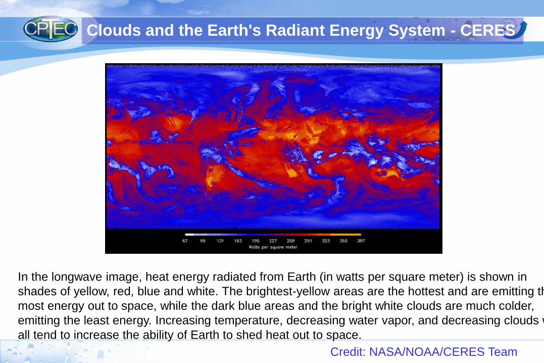
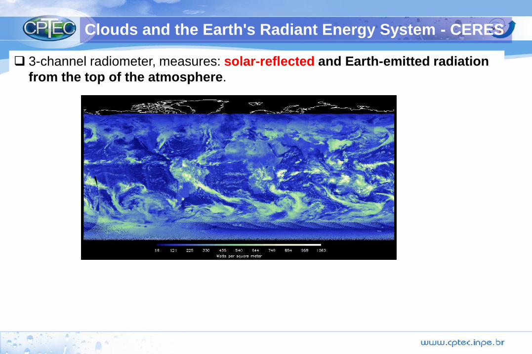
In the longwave image, heat energy radiated from Earth (in watts per square meter) is shown in
shades of yellow, red, blue and white. The brightest-yellow areas are the hottest and are emitting the
most energy out to space, while the dark blue areas and the bright white clouds are much colder,
emitting the least energy. Increasing temperature, decreasing water vapor, and decreasing clouds will
all tend to increase the ability of Earth to shed heat out to space.
Credit: NASA/NOAA/CERES Team
Clouds and the Earth's Radiant Energy System - CERES

Como o INPE está se preparando?
:
Conclusão:
•Somente satélites podem:
• Monitorar a evolução do ciclo de vida de sistema de tempo
(RADAR)
• Realizar análise global e assimilação de dados.
• Coletar dados em todo o globo -> intercomparar regiões com o
mesmo sensor.
• Obter grande cobertura de dados em tempo real integrado em
uma única plataforma.
• Observar diversas informações sobre a atmosfera devido a
capacidade de resolução temporal, espacial e espectral.
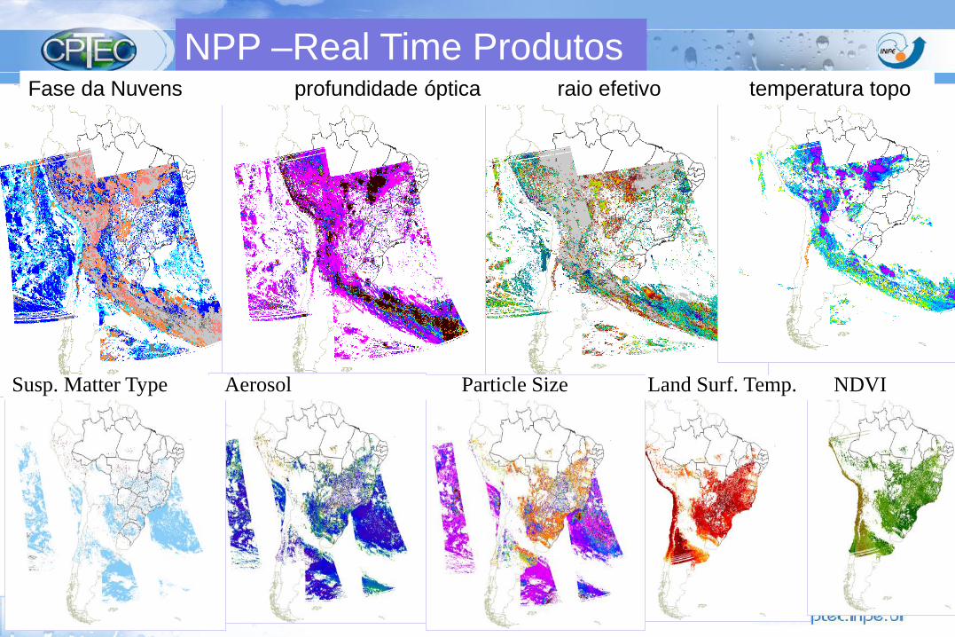
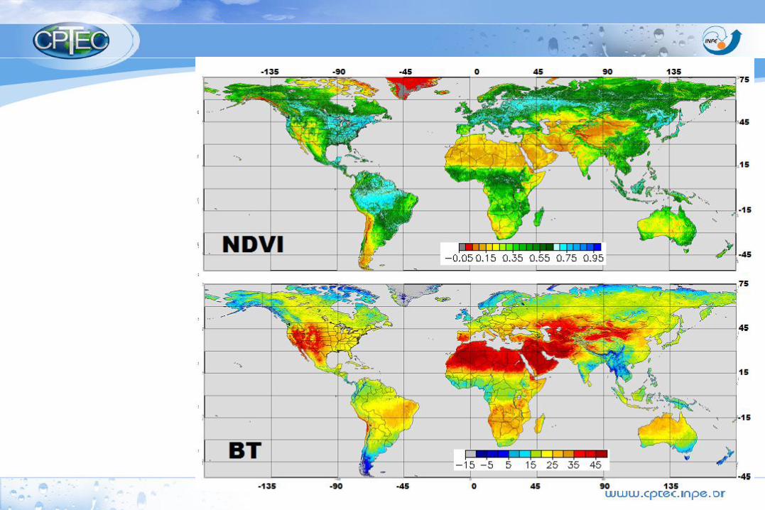
NPP –Real Time Produtos Fase da Nuvens profundidade óptica raio efetivo temperatura topo
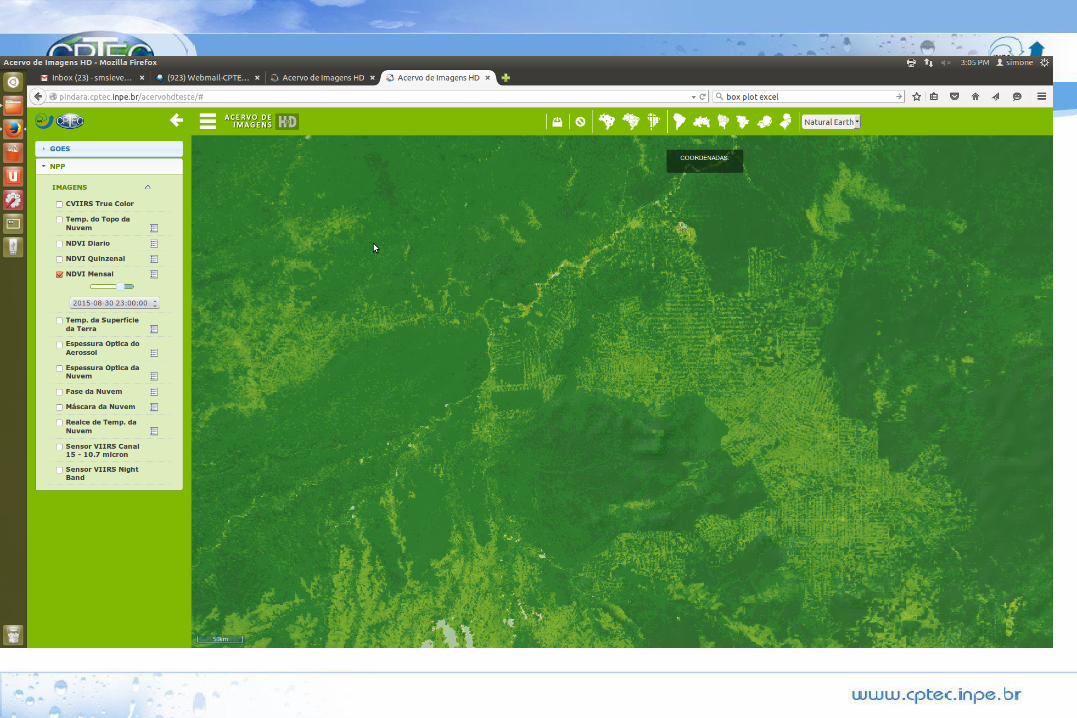
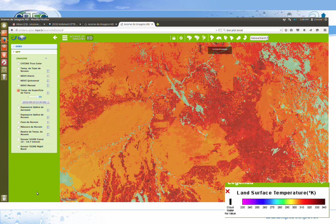
Susp. Matter Type Aerosol Particle Size Land Surf. Temp. NDVI
VIIRS/ NPP
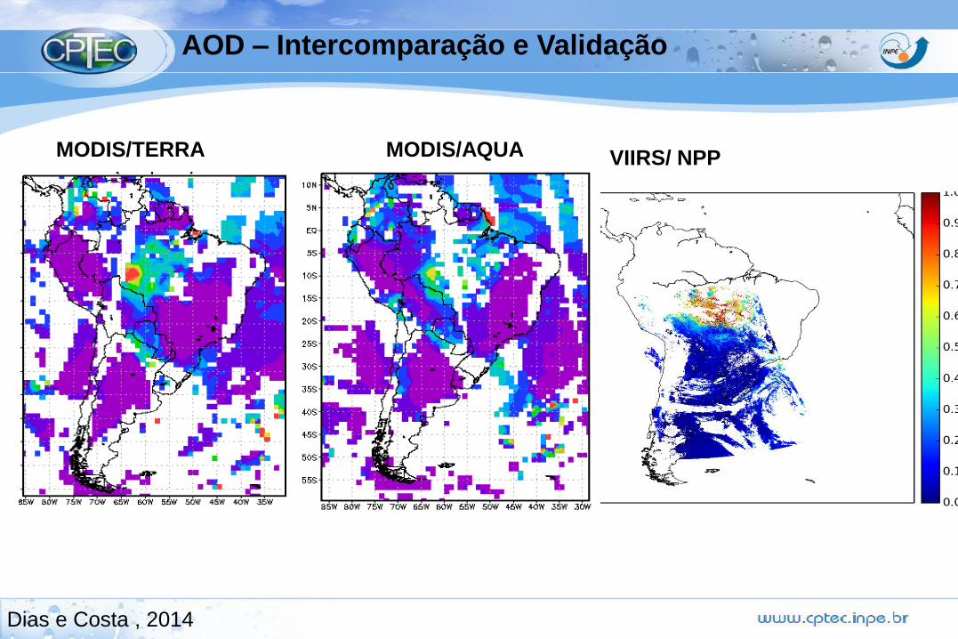
AOD – Intercomparação e Validação
MODIS/AQUA
Dias e Costa , 2014
MODIS/TERRA
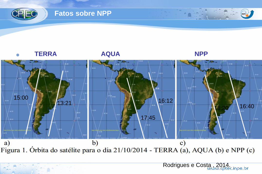
Fatos sobre NPP
•
16:4016:12
18:20
17:45
13:2115:00
TERRA AQUA NPP
Rodrigues e Costa , 2014.
Sensoriamento Remoto da Atmosfera
Alguns Desafios
Transformar radiâncias em produtos meteorológicos e ambientais.
Obter informações sobre o potencial de severidade de um evento
antes que ela se desenvolva.
Tratar milhares de canais de forma objetiva.
Utilizar a nova geração de satélite para melhorar a previsão de
tempo e o monitoramento ambiental.
Curso de Satélite : 04 a 08 de Maio de 2015
LEITURA – VIIRS VIIRS and Ocean Science
VIIRS, a scanning radiometer, collects visible and infrared imagery and radiometric measurements of the land, atmosphere,
cryosphere, and oceans. VIIRS data is used to measure cloud and aerosol properties, ocean color, sea and land surface
temperature, ice motion and temperature, fires, and Earth's albedo. Climatologists use VIIRS data to improve our understanding of
global climate change.
Accurate satellite measurements of ocean pigment concentrations and sea surface temperature (SST) were first demonstrated
with the Nimbus-7 Coastal Zone Color Scanner (CZCS) and the NOAA-7 Advanced Very High Resolution Radiometer (AVHRR)
launched in 1978 and 1981, respectively. Subsequent missions like the Sea-viewing Wide Field-of-view Sensor (SeaWiFS) and
the Moderate Resolution Imaging Spectroradiometer (MODIS) have provided high quality time series of these and other properties
by expanding the spectral information and calibration accuracy, and by improving the processing algorithms.
Like MODIS, VIIRS is a multi-disciplinary sensor providing data for the ocean, land, aerosol, and cloud research and operational
users. VIIRS spectral coverage will allow for data products similar to those from SeaWiFS as well as SST, a standard MODIS
product. SST is an Essential Climate Variable (ECV) and, through validation with instruments traceable to NIST standards, is a
Climate Data Record. Also, as with SeaWiFS and MODIS, the VIIRS scan and orbit geometries will provide global coverage every
two days.
Measurement of pigment concentrations, water clarity, suspended particulates and other properties in coastal regions are critical
for coastal zone management, fisheries management, and naval operations. Specific applications that VIIRS can continue include
operational forecasts of harmful algal blooms in the Gulf of Mexico, detection of areas at high risk for coral bleaching due to
temperature, assessing fish recruitment and climate impacts, and assessing primary productivity and ecosystem health in ocean
basins and coasts.
Similarly, accurate estimates of SST are essential for many applications such as hurricane prediction and weather forecasting. The
VIIRS SST data will be used to continue the decadal global SST time series currently derived from the AVHRR, MODIS and other
sensors that is critical for climate change research. VIIRS products will augment other satellite products to provide important real-
time ocean products for the U.S. Navy.
VIIRS and Cloud
Science
In general, clouds cover about 70 percent of the planet on any given day. They influence the amount of sunlight reaching the surface, and they regulate the amount of energy--both
solar and thermal--that reaches space.
Since 1980, polar-orbiting weather satellites have included both imagers and sounders. These types of sensors record data continuously, using different wavelengths to infer
information about clouds on a global scale. They can determine cloud top height and thermodynamic phase (ice or water particles), and make estimates of microphysical and optical
properties that indicate the amount of water and ice in the cloud layer.
The cloud products derived from VIIRS and CrIS will serve a range of communities. For example, information on cloud cover is needed by the solar energy community to optimize
energy production. Cloud products are being used increasingly in nowcasting models (up to 9 hours in the future) and in numerical weather prediction models (perhaps several days in
the future). Such products are used to determine the probability of precipitation or severe weather.
Since such models requires that cloud products be available soon after the data are collected, data reduction must be timely and efficient. On a longer time scale, these cloud data are
used to build climate data records that are critical for establishing a decadal record of cloud properties. Technical issues associated with deriving a long-term data set of cloud
properties require continual work on sensor calibration and refinement of algorithms.
Historically, cloud information was provided by the Advanced Very High Resolution Radiometer (AVHRR) and the High resolution InfraRed Sounder (HIRS). On the NASA Earth
Observing System Aqua and Terra platforms, such measurements are provided by the MODerate resolution Imaging Spectroradiometer (MODIS) and the Atmospheric Infrared
Sounder (AIRS). Over time, the technology behind these imager and sounder sensors has improved, with the latest imager being the Visible Infrared Imager Radiometer Suite (VIIRS)
and the Cross-track Infrared Sounder (CrIS).
VIIRS will provide information about clouds, aerosol, and surface properties at a spatial resolution of about 750 m for most spectral measurements. VIIRS records data at a set of
discrete wavelengths from the ultraviolet (0.45 _m) to the infrared (12 _m). CrIS is a hyperspectral (> 1000 spectral wavelengths) sensor that will provide complementary information
about clouds, especially in complex regions such as the poles, over bright surfaces such as snow/ice, and in areas that have strong temperature inversions.
The cloud properties from VIIRS, and in some regions from VIIRS combined with CrIS, will maintain continuity with the decadal cloud record from 1980 to the present that is provided
by historical and current sensors such as AVHRR, HIRS, MODIS, and AIRS. VIIRS cloud products will be available at higher spatial resolution, and will be well-calibrated, which is
essential for its use in continuing the climate record.

Impacto
dos Satélites
na PNT
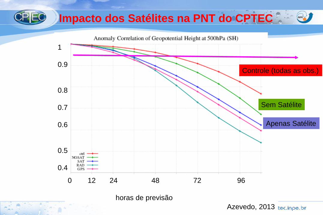
Azevedo, 2013
0 12 24 48 72 96
horas de previsão
1
0.9
0.8
0.7
0.6
0.5
0.4
Controle (todas as obs.)
Sem Satélite
Apenas Satélite
Impacto dos Satélites na PNT do CPTEC
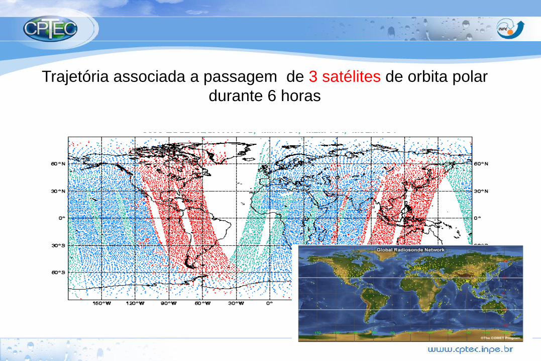
Trajetória associada a passagem de 3 satélites de orbita polar
durante 6 horas
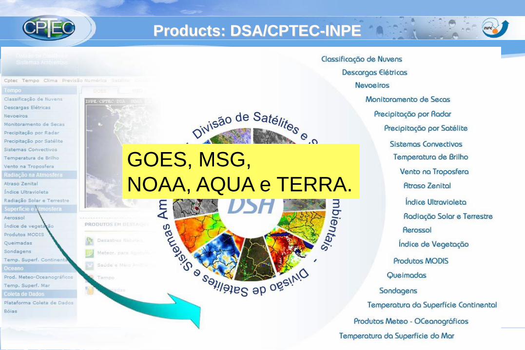
Products: DSA/CPTEC-INPE
GOES, MSG,
NOAA, AQUA e TERRA.
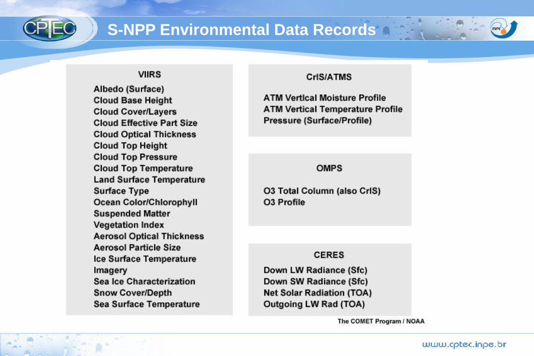
S-NPP Environmental Data Records
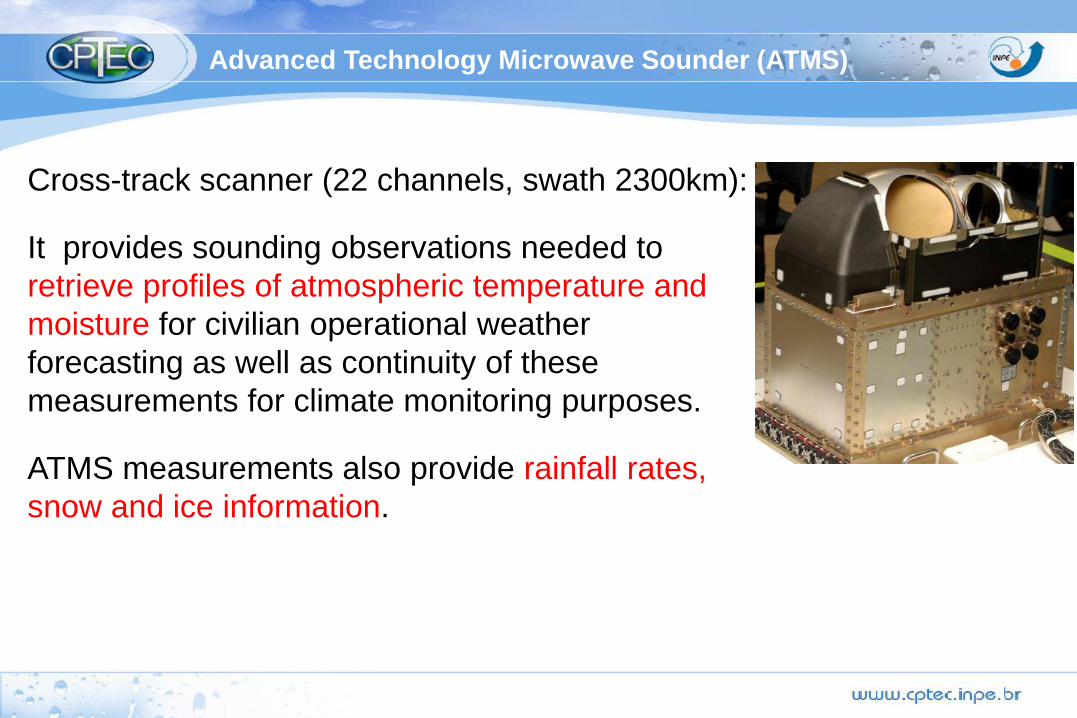
Cross-track scanner (22 channels, swath 2300km):
It provides sounding observations needed to
retrieve profiles of atmospheric temperature and
moisture for civilian operational weather
forecasting as well as continuity of these
measurements for climate monitoring purposes.
ATMS measurements also provide rainfall rates,
snow and ice information.
Advanced Technology Microwave Sounder (ATMS)
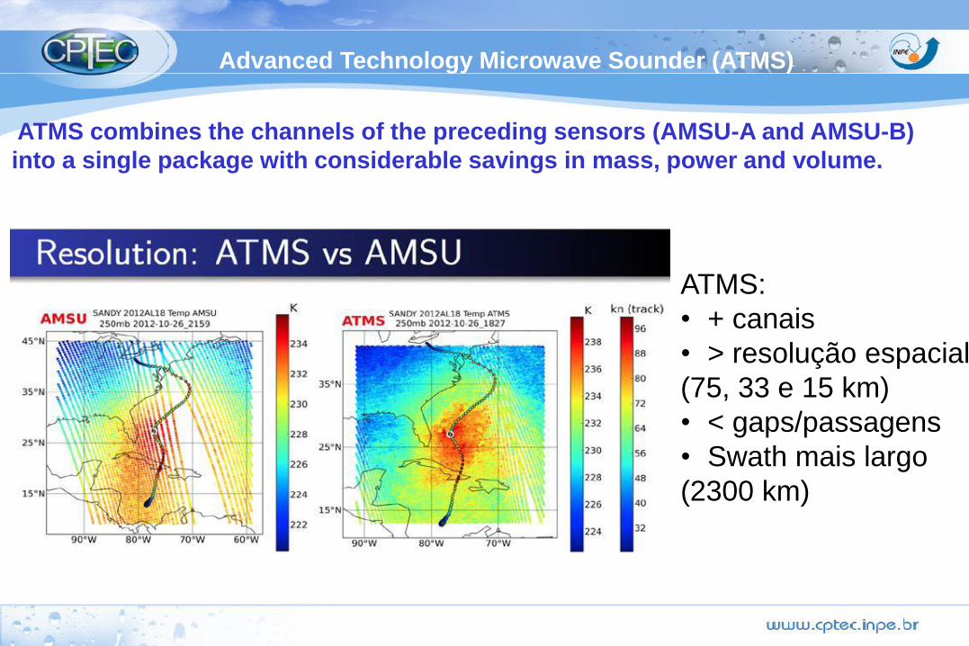
Advanced Technology Microwave Sounder (ATMS)
ATMS combines the channels of the preceding sensors (AMSU-A and AMSU-B)
into a single package with considerable savings in mass, power and volume.
ATMS:
• + canais
• > resolução espacial
(75, 33 e 15 km)
• < gaps/passagens
• Swath mais largo
(2300 km)
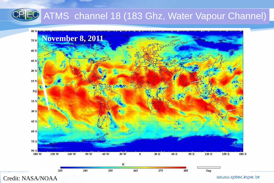
ATMS channel 18 (183 Ghz, Water Vapour Channel)
Credit: NASA/NOAA
November 8, 2011
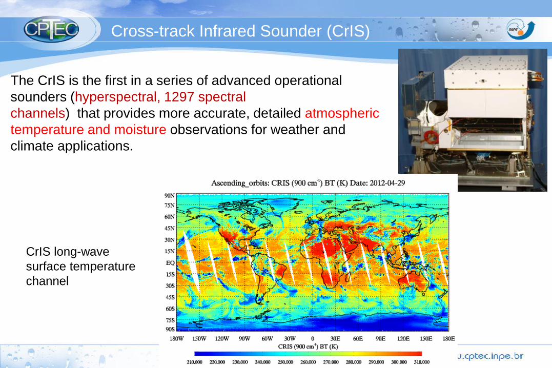
Cross-track Infrared Sounder (CrIS)
The CrIS is the first in a series of advanced operational
sounders (hyperspectral, 1297 spectral
channels) that provides more accurate, detailed atmospheric
temperature and moisture observations for weather and
climate applications.
CrIS long-wave
surface temperature
channel
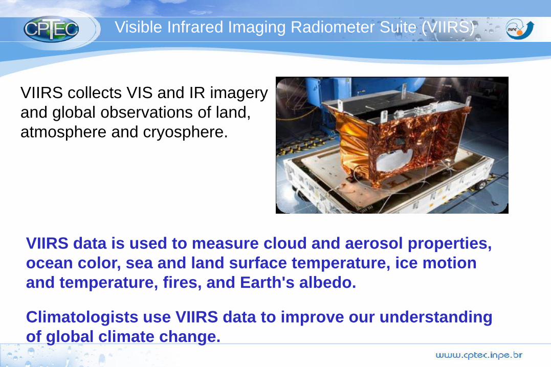
Visible Infrared Imaging Radiometer Suite (VIIRS)
VIIRS collects VIS and IR imagery
and global observations of land,
atmosphere and cryosphere.
VIIRS data is used to measure cloud and aerosol properties,
ocean color, sea and land surface temperature, ice motion
and temperature, fires, and Earth's albedo.
Climatologists use VIIRS data to improve our understanding
of global climate change.
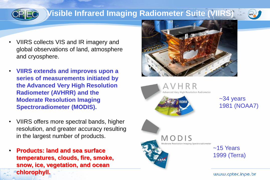
• VIIRS collects VIS and IR imagery and
global observations of land, atmosphere
and cryosphere.
• VIIRS extends and improves upon a
series of measurements initiated by
the Advanced Very High Resolution
Radiometer (AVHRR) and the
Moderate Resolution Imaging
Spectroradiometer (MODIS).
• VIIRS offers more spectral bands, higher
resolution, and greater accuracy resulting
in the largest number of products.
• Products: land and sea surface
temperatures, clouds, fire, smoke,
snow, ice, vegetation, and ocean
chlorophyll.
~15 Years
1999 (Terra)
~34 years
1981 (NOAA7)
Visible Infrared Imaging Radiometer Suite (VIIRS)
3-channel radiometer, measures: solar-reflected and Earth-emitted radiation
from the top of the atmosphere.
Clouds and the Earth's Radiant Energy System - CERES

3-channel radiometer, measures: solar-reflected and Earth-emitted radiation
from the top of the atmosphere.
cloud properties ( amount, height, thickness, particle size, and phase of
clouds) using simultaneous measurements by other instruments. )
Clouds and the Earth's Radiant Energy System - CERES
CERES measurements are critical for understanding cloud-radiation effects.
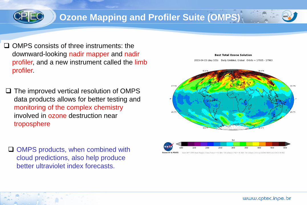
OMPS consists of three instruments: the
downward-looking nadir mapper and nadir
profiler, and a new instrument called the limb
profiler.
Ozone Mapping and Profiler Suite (OMPS)
OMPS products, when combined with
cloud predictions, also help produce
better ultraviolet index forecasts.
The improved vertical resolution of OMPS
data products allows for better testing and
monitoring of the complex chemistry
involved in ozone destruction near the
troposphere

Limb profiler.
The limb profiler is a experimental instrument that
measures the O3 distribution at higher vertical resolution.
Ozone Mapping and Profiler Suite (OMPS)
It's designed to continue NASA's measurements of high vertical resolution ozone
profiles from the Microwave Limb Sounder on the EOS Aura, data key to
understanding how changing greenhouse gases affect the recovery of the ozone layer.
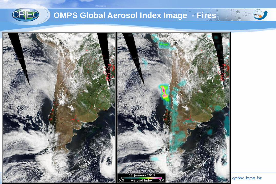
OMPS Global Aerosol Index Image - Fires

JPSS Joint Polar Satellite System: Overview
JPSS consists of three satellites (Suomi NPP, JPSS-1, JPSS-2),
ground system and operations through 2025.
Mission: provide global imagery and atmospheric
measurements using polar-orbiting satellites .
JPSS is a partnership between NOAA and NASA:
NOAA: responsible for overall program commitment (operations,
science, data exploitation and archiving.)
NASA: acquisition agent for the flight system (satellite,
instruments and launch vehicle) and ground system.
It leads program systems engineering, and program safety
and mission assurance.
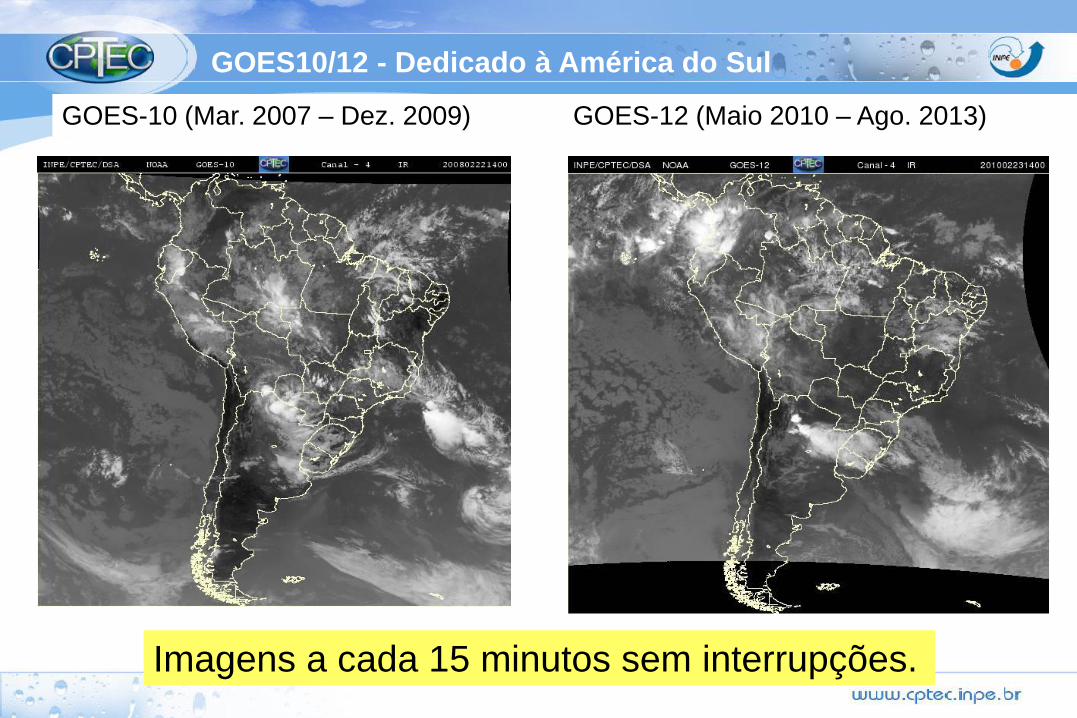
GOES10/12 - Dedicado à América do Sul
GOES-10 (Mar. 2007 – Dez. 2009) GOES-12 (Maio 2010 – Ago. 2013)
Imagens a cada 15 minutos sem interrupções.
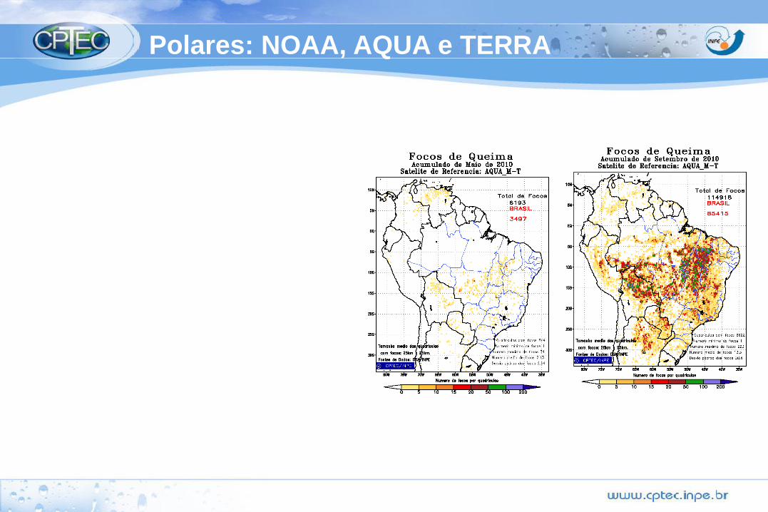
Polares: NOAA, AQUA e TERRA
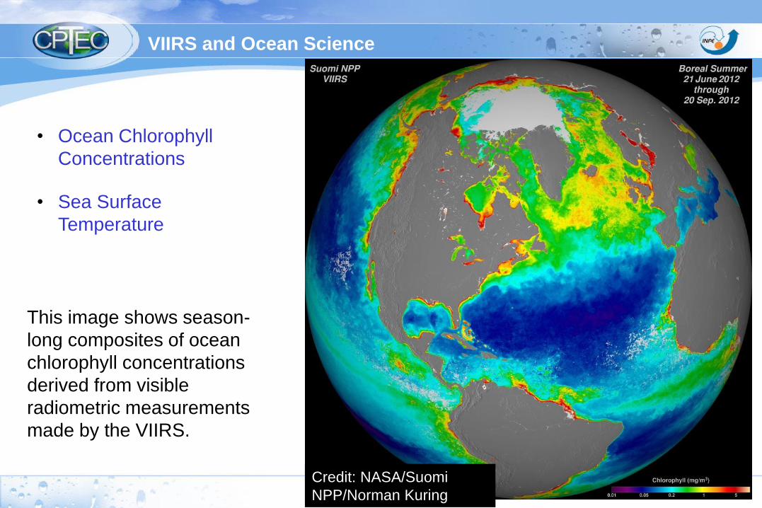
This image shows season-
long composites of ocean
chlorophyll concentrations
derived from visible
radiometric measurements
made by the VIIRS.
Credit: NASA/Suomi
NPP/Norman Kuring
VIIRS and Ocean Science
• Ocean Chlorophyll
Concentrations
• Sea Surface
Temperature
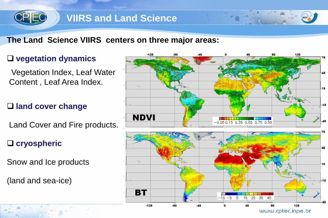
The Land Science VIIRS centers on three major areas:
vegetation dynamics
Vegetation Index, Leaf Water
Content , Leaf Area Index.
land cover change
Land Cover and Fire products.
cryospheric
Snow and Ice products
(land and sea-ice)
VIIRS and Land Science

S-NPP Algorithm
Maturity
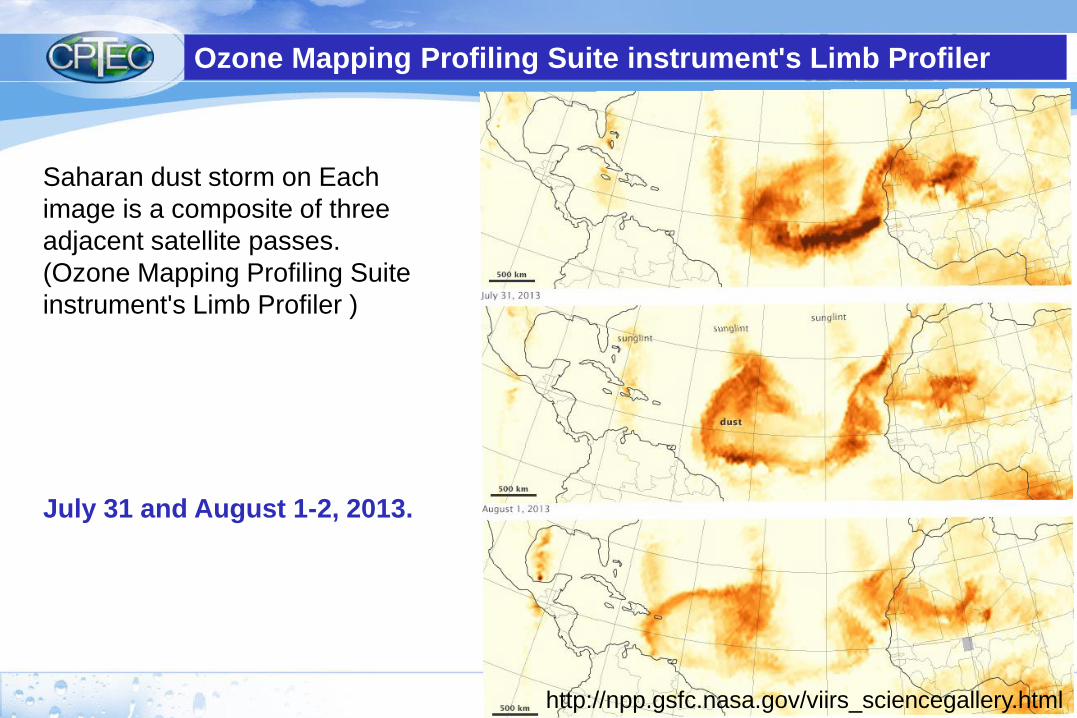
Saharan dust storm on Each
image is a composite of three
adjacent satellite passes.
(Ozone Mapping Profiling Suite
instrument's Limb Profiler )
http://npp.gsfc.nasa.gov/viirs_sciencegallery.html
July 31 and August 1-2, 2013.
Ozone Mapping Profiling Suite instrument's Limb Profiler