anurio do instituto de geociências - urj ... · resumo a natureza da sedimentação e as taxas de...
TRANSCRIPT

5
Anuário do Instituto de Geociências - UFRJ www.anuario.igeo.ufrj.br
Coastal Sedimentation in a Tropical Barrier-Island System During the Past Century in Sepetiba Bay, Brazil
Sedimentação Costeira em um Sistema de Ilha-de-Barreira Tropical Durante o Último Século na Baía de Sepetiba
Heloisa Vargas Borges 1 & Charles A. Nittrouer 2
1 Universidade Federal Fluminense, Instituto de Geociências, Departamento de Geologia. Av. Gal. Milton Tavares de Souza, s/nº, 4° andar, - Campus da Praia Vermelha – Gragoatá, 24.210346 Niterói, Brasil
2 University of Washington - School of Oceanography Box 357940, Seattle, WA USA E-mails: [email protected]; [email protected]
Recebido em: 08/09/2015 Aprovado em: 02/03/2016DOI: http://dx.doi.org/10.11137/2016_2_05_14
Abstract
The nature of sedimentation and sediment accumulation rates in Sepetiba Bay, Brazil were interpreted from grain-size patterns, natural radiochemical distributions and seismic stratigraphy. The grain-size analyses showed progressive upward fining of sediment in cores, and a higher percentage of clay in surficial deposits in 1996 than observed during a previous spatial survey in the 1970s. Based on 210Pb geochronology, accumulation rates range from 0.37 cm yr-1 to 2.0 cm yr-1 for the last hundred years. In contrast, seismic stratigraphy indicates a range from 0.01 to 0.17 cm yr-1 over the last 7000 years. Particularly high accumulation rates are found in the northeast part of the bay, and, as a consequence of these high rates, the shoreline in the northern part of the bay prograded approximately 400 m in the last 100 years. An apparent increase in accumulation rates and a tendency for deposits to fine upward over the last ~ 100 years are attributed to human disturbance and soil erosion inland, which have been accelerated with economic development since the late 1970s. Keywords: 210Pb geochronology; sedimentation; Sepetiba Bay; seismic stratigraphy
Resumo
A natureza da sedimentação e as taxas de sedimentação na Baía de Sepetiba, Brasil, foram interpretadas a partir dos padrões granulométricos, distribuição radiométrica natural e estratigrafia sísmica. A análise granulométrica mostrou uma diminuição progressiva no tamanho dos grãos nos testemunhos e uma alta porcentagem de argila em depósitos superficiais em 1996, do que a observada durante um levantamento anterior nos anos 70. Baseado em datações por 210Pb, as taxas de acumulação variam de 0.37 cm/ano a 2.0 cm/ano, para os últimos 100 anos. Em contrapartida, a estratigrafia sísmica indica uma variação de 0.01 a 0.17 cm/ano ao longo dos últimos 7000 anos. Taxas de acumulação particularmente altas são encontradas na parte nordeste da baía e, em consequência destas altas taxas, a linha de costa na parte norte da baía progradou aproximadamente 400 m nos últimos 100 anos. Um aumento aparente nas taxas de acumulação e uma tendência à deposição de sedimentos finos ao longo dos últimos 100 anos, são atribuídos à ação. Palavras-chave: Geocronologia do 210Pb; sedimentação; Baía de Sepetiba; estratigrafia sísmica
A n u á r i o d o I n s t i t u t o d e G e o c i ê n c i a s - U F R JISSN 0101-9759 e-ISSN 1982-3908 - Vol. 39 - 2 / 2016 p. 05-14

6A n u á r i o d o I n s t i t u t o d e G e o c i ê n c i a s - U F R JISSN 0101-9759 e-ISSN 1982-3908 - Vol. 39 - 2 / 2016 p. 05-14
Coastal Sedimentation in a Tropical Barrier-Island System During the Past Century in Sepetiba Bay, BrazilHeloisa Vargas Borges & Charles A. Nittrouer
1 Introduction
Mangrove forests are dominant features of tropical and subtropical coastlines around the world. The fine-grained sediment in these areas is associated with high suspended-sediment delivery to the coast by nearby rivers, which is then trapped in intertidal settings dominated by the mangrove forests (Woodroffe, 1992, 2013). These forests thrive in low-energy tropical environments and can grow in a wide variety of substrates, including muddy shorelines, sand, volcanic lava, and carbonate sediments (Chapman, 1976, 1977). Mangrove shorelines are classified by environmental settings, based on landforms and the physical processes for sediment transport and deposition (Thom, 1982, 1984). Deposition of fine-grained sediment in mangrove forests is promoted by roots and pneumatophores, which baffle flow and effectively reduce water movement (Wolanski et al., 1992; Wolanski, 1995). Additionally, the fine roots act to bind sediment (Scoffin, 1970).
Different methods of measurement have been used to determine sediment accumulation rates in mangrove forests. Direct methods include the use of marker stakes in dwarf Avicennia forests; accumulation rates using stakes were up to 0.8 cm yr –1 in southern Australia (Bird, 1971) and 0.46 cm yr –1 in northeastern Australia (Spenceley, 1977, 1982). More recently, 210Pb and 137Cs radioisotopes have been used to determine short-term accumulation rates in mangrove forests of Mexico, and showed rates of 0.3 cm yr –1 (Lynch et al., 1989). In the early Holocene mangroves of northern Australia, long-term sediment accumulation rates, determined by the use of radiocarbon, were shown to be up to 6 mm yr –1 (Woodroffe, 1990).
Human factors can significantly influence coastal sedimentation. Activities that increase soil erosion, for example, may consequently increase the fluvial sediment input to deltaic and other coastal environments (Ellison & Stoddart, 1991). Studies in mangrove regions of the south Pacific Ocean estimate accumulation rates, using radiocarbon dating and stratigraphy data, of 7.6-13.1 cm yr-1 (Southern, 1986) in Fiji and 3-25.3 cm yr-1 (Bloom, 1970) for the Carolina Islands were due to human disturbance involving soil erosion.
The objectives of this paper are: 1) to evaluate the sediment accumulation rates based on 210Pb measurements in the mangrove forest of the Guaratiba tidal flat, Brazil; 2) to relate these rates to changes in physical and biological processes inside Sepetiba Bay; and 3) to evaluate possible links between the accumulation rates and human activities in the surrounding areas.
2 Study Area
The study area is located in the state of Rio de Janeiro, in the southeastern part of Brazil (Figure 1). Sepetiba Bay is an elliptically shaped coastal embayment, covering an area of 300 km2. It is connected to the ocean at two sites: through a tidal channel at Barra de Guaratiba and through a series of larger channels at the west end (Figure 1). The western region is partially enclosed by a chain of islands made of granites, gneisses and migmatites, which follow a NE/SW structural lineation of the coastline. The coastal plain is composed of Holocene mangroves, dunes, beaches and alluvial plains.
The Sepetiba-Guaratiba coastal complex includes a sandy barrier island (Marambaia Barrier Island), a lagoon (Sepetiba Bay), a small delta dominated by fluvial processes (associated with Guandú River) and a tidal flat, 100-500 m long, partially covered with mangroves (Guaratiba tidal flat) (Figure 1). The fluvial contribution to Sepetiba Bay comes from the Guandú, Itagui, Mazomba, Cabuçú, and Piracão Rivers. Two of these rivers, the Itagui and the Guandú, were modified during the 1940s into artificial, fixed channels. After these changes, the largest river, Guandú, received additional discharge from other small rivers of the region (CONCREMATI, 1992). The maximum flood discharge increased from 190 m3/s in the 1940s (Goes, 1942) to 288 m3/s in the last 20 years (verbal communication, SERLA, 1997).
The climate in Sepetiba Bay is mesothermic, hot summer and dry winter, with annual average temperature of 21°C. The annual rainfall average in the area is 1300 mm, maximum of 125 days/year, with 79% humidity (CONCREMATI, 1992).
The currents inside the bay are driven by tides and can reach maximum speeds of 75 cm/sec

7A n u á r i o d o I n s t i t u t o d e G e o c i ê n c i a s - U F R JISSN 0101-9759 e-ISSN 1982-3908 - Vol. 39 - 2 / 2016 p. 05-14
Coastal Sedimentation in a Tropical Barrier-Island System During the Past Century in Sepetiba Bay, BrazilHeloisa Vargas Borges & Charles A. Nittrouer
in the channels between the islands of Itacuruçá and Jaguanum (DHN, 1986; Villena, 2003). The seawater that enters the bay as a bottom current is relatively cold and dense. It circulates clockwise through the bay, becomes warmer, and exits at the surface between Marambaia Peak and Jaguanum Island (Figure 2). The tide in the area has a moderate to small amplitude of 110 cm during
spring tide and 30 cm during neap tide. There is a difference in phase of about 15 minutes between the entrances and the far interior of the bay (DHN, 1986; Villena, 2003). Sepetiba Bay can be divided into three compartments based on its hydrographic and geographic characteristics: brackish (3-18‰), hyposaline (18-30‰) and hypersaline (30-40‰) (Moura et al., 1982).
Figure 1 Sepetiba Bay study area and
its generalized bathymetry. Upper right insert shows the area along the south
Brazilian coast. Upper left insert shows location of
Sepetiba Bay west of Rio de Janeiro City.
Figure 2 Generalized current system at Sepetiba
Bay. Cold and dense water enters the bay as a
bottom current, circulates clockwise through the bay, becomes warmer, and exits
as surface current.
8A n u á r i o d o I n s t i t u t o d e G e o c i ê n c i a s - U F R JISSN 0101-9759 e-ISSN 1982-3908 - Vol. 39 - 2 / 2016 p. 05-14
Coastal Sedimentation in a Tropical Barrier-Island System During the Past Century in Sepetiba Bay, BrazilHeloisa Vargas Borges & Charles A. Nittrouer
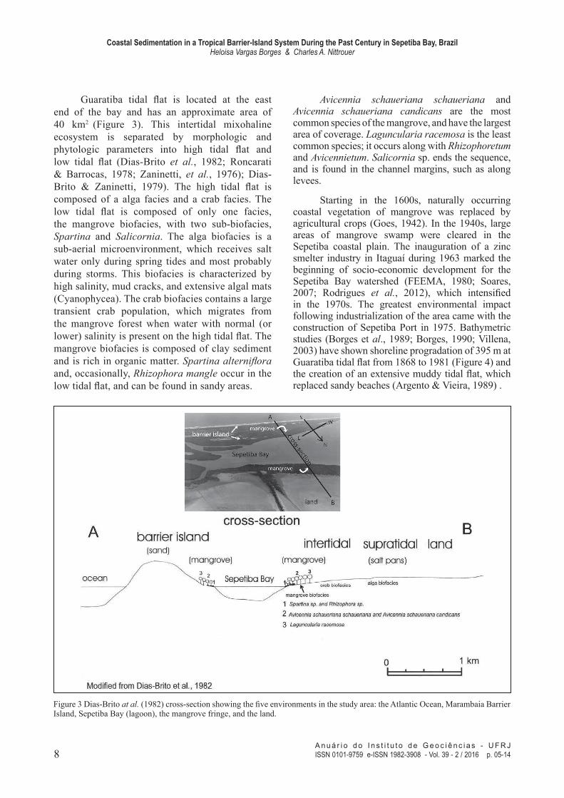
Guaratiba tidal flat is located at the east end of the bay and has an approximate area of 40 km2 (Figure 3). This intertidal mixohaline ecosystem is separated by morphologic and phytologic parameters into high tidal flat and low tidal flat (Dias-Brito et al., 1982; Roncarati & Barrocas, 1978; Zaninetti, et al., 1976); Dias-Brito & Zaninetti, 1979). The high tidal flat is composed of a alga facies and a crab facies. The low tidal flat is composed of only one facies, the mangrove biofacies, with two sub-biofacies, Spartina and Salicornia. The alga biofacies is a sub-aerial microenvironment, which receives salt water only during spring tides and most probably during storms. This biofacies is characterized by high salinity, mud cracks, and extensive algal mats (Cyanophycea). The crab biofacies contains a large transient crab population, which migrates from the mangrove forest when water with normal (or lower) salinity is present on the high tidal flat. The mangrove biofacies is composed of clay sediment and is rich in organic matter. Spartina alterniflora and, occasionally, Rhizophora mangle occur in the low tidal flat, and can be found in sandy areas.
Avicennia schaueriana schaueriana and Avicennia schaueriana candicans are the most common species of the mangrove, and have the largest area of coverage. Laguncularia racemosa is the least common species; it occurs along with Rhizophoretum and Avicennietum. Salicornia sp. ends the sequence, and is found in the channel margins, such as along levees.
Starting in the 1600s, naturally occurring coastal vegetation of mangrove was replaced by agricultural crops (Goes, 1942). In the 1940s, large areas of mangrove swamp were cleared in the Sepetiba coastal plain. The inauguration of a zinc smelter industry in Itaguaí during 1963 marked the beginning of socio-economic development for the Sepetiba Bay watershed (FEEMA, 1980; Soares, 2007; Rodrigues et al., 2012), which intensified in the 1970s. The greatest environmental impact following industrialization of the area came with the construction of Sepetiba Port in 1975. Bathymetric studies (Borges et al., 1989; Borges, 1990; Villena, 2003) have shown shoreline progradation of 395 m at Guaratiba tidal flat from 1868 to 1981 (Figure 4) and the creation of an extensive muddy tidal flat, which replaced sandy beaches (Argento & Vieira, 1989) .
Figure 3 Dias-Brito at al. (1982) cross-section showing the five environments in the study area: the Atlantic Ocean, Marambaia Barrier Island, Sepetiba Bay (lagoon), the mangrove fringe, and the land.

9A n u á r i o d o I n s t i t u t o d e G e o c i ê n c i a s - U F R JISSN 0101-9759 e-ISSN 1982-3908 - Vol. 39 - 2 / 2016 p. 05-14
Coastal Sedimentation in a Tropical Barrier-Island System During the Past Century in Sepetiba Bay, BrazilHeloisa Vargas Borges & Charles A. Nittrouer
3 Methods3.1 Field
Two push cores, MG1 and MG2 and one gravity core, SB2, were collected from Pedra de Guaratiba tidal flat during July 1996 (Figure 5).
The push cores were collected during low tide along a transect from the shore seaward. The gravity core was collected from a small vessel in the subtidal region. Samples for sedimentological and radiochemical analyses were taken at 2-cm intervals down core to 80 cm depth and individual samples were then homogenized.
Figure 4 Cross-section showing the shoreline progradation of 400
m at Guaratiba tidal flat from 1868 to 1981 (Borges, 1990).
Figure 5 A. General view of the study area with environments and locations of MG1,
MG2, and SB2 cores;
B. Detail of the city of Pedra de
Guaratiba and development
around the mangrove fringe; C. Tidal channels at the east end of
Sepetiba Bay; D. Aerial view of
Pedra de Guaratiba mangrove forest and algal mats.

10A n u á r i o d o I n s t i t u t o d e G e o c i ê n c i a s - U F R JISSN 0101-9759 e-ISSN 1982-3908 - Vol. 39 - 2 / 2016 p. 05-14
Coastal Sedimentation in a Tropical Barrier-Island System During the Past Century in Sepetiba Bay, BrazilHeloisa Vargas Borges & Charles A. Nittrouer
3.2 Laboratory
Samples were sieved to eliminate organic matter. Grain size was analyzed on a Sedigraph model 5100, following the methods of Coakley & Syvitski (1991).
A modified version of the Nittrouer et al. (1979) method was used for 210Pb analysis. Samples were weighed, then dried at 60° C. Porosity was calculated from the weight loss of water. Approximately 5 g of sediment was spiked with 209Po (as a yield determinant). Samples were leached with hot concentrated HNO3 (15 ml) and HCl (5ml) solutions and taken to dryness over a four-hour period and then 20 ml of 6N HCl were added in order to dissolve the residue. The solution was centrifuged and the supernatant was poured into 150 ml glass jars with silver planchets. 210Pb activities were measured by alpha spectrometry from decay of the 210Po daughter. Samples were corrected for salt content and normalized to a representative porosity (75%).
4 Results4.1 Grain-Size Distribution and Core Description
Samples analyzed for grain-size were created by combing samples over 15-cm intervals. Concentrations of silt and clay are given in Table 1 and the dominant grain size in the cores was clay (£ 8f), followed by silt (4f-7f). The MG1 core, collected at the mangrove fringe (Figure 6), shows an overall fining up with decrease of silt, from 27 to 9 %. The clay percentage in the MG1 core varies from 73 to 91%. The MG2 core, collected in the forest basin (Figure 6), had a higher silt content (25%) in the top of the core, decreasing to 11% at 30-cm depth. From this depth, silt content increased to 22% at the bottom. The SB2 core, collected at the tidal flat (Figure 6), showed an increase of silt from 8% at the top of the core to 22% at 15 cm deep, remaining constant to the bottom of the core.
The organic-carbon content in the three cores varied along the transect and with depth in cores and consisted of very small fragments of leaf, wood (branch and bark), and roots. Core-MG2 carbon content is likely related to two types of root
fragments, one 3-mm thick and one hair-like (~ 0.15 mm), which were found at all depths in the core. A well-preserved fragment of bark was found in the interval 69-71 cm, and small pieces of branch were found to 9-cm depth. Thin roots (hair like) were found in core MG1from the top of the core to 60 cm. A bivalve shell was located at a depth of 40 cm. Core SB2, from the tidal flat, did not show any plant debris.
Core Interval (cm) Silt % Clay %0.25 12 881.50 9 9115.0 22 78
MG1 30.0 22 7745.0 21 7960.0 27 7375 24 76
1.50 25 7515.0 18 82
MG2 30.0 11 8945.0 22 7860.0 19 8175.0 22 78
0.25 8 9220.0 22 78
SB2 30.0 22 7845.0 22 7860.0 23 7775.0 22 78
4.2 Radiochemistry
Profiles of 210Pb activity with depth for the three cores are presented in Figure 7 and 210 Pb activities for all cores are found in Table 2.
Table 1 Silt and clay content at intervals of 15 cm along cores MG1, MG2, and SB2.
Figure 6 Percentage of silt and clay by depth for MG1, MG2 and SB2 cores showing the dominance of clay-size particles at all sites.

11A n u á r i o d o I n s t i t u t o d e G e o c i ê n c i a s - U F R JISSN 0101-9759 e-ISSN 1982-3908 - Vol. 39 - 2 / 2016 p. 05-14
Coastal Sedimentation in a Tropical Barrier-Island System During the Past Century in Sepetiba Bay, BrazilHeloisa Vargas Borges & Charles A. Nittrouer
Table 2 210Pb activities at collection (dpm); excess activity in dpm/g; dry bulk density (g/cm3); and error of measurements forMG1, MG2, and SB2 core samples.
Salt corrected
Core Interval center
210Pb activityat collection
Error (+/-)
Excess activity (dpm/g) Dry bulk density Error
0 - 1 3.11 0.15 2.55 0.40 0.1210 – 11 3.42 0.18 2.87 0.44 0.1520 – 21 3.35 0.12 2.80 0.45 0.1030 – 31 3.24 0.12 2.69 0.48 0.10
MG1 40 – 41 2.72 0.11 2.16 0.46 0.0950 – 51 2.49 0.10 1.92 0.49 0.0860 – 61 2.28 0.09 1.71 0.50 0.0770 – 71 2.06 0.08 1.48 0.54 0.0680 – 81 1.98 0.09 1.40 0.56 0.06
0 - 1 3.54 0.13 2.99 0.49 0.1110 – 11 3.29 0.13 2.74 0.47 0.1120 – 21 2.45 0.22 1.88 0.51 0.1730 – 31 2.25 0.10 1.68 0.52 0.07
MG2 40 – 41 2.08 0.11 1.50 0.47 0.0850 – 51 1.90 0.12 1.32 0.43 0.0860 – 61 1.81 0.11 1.23 0.48 0.0770 – 71 1.96 0.14 1.38 0.46 0.1080 – 81 2.12 0.20 1.54 0.52 0.15
0 - 1 3.76 0.15 3.22 0.20 0.1310 – 11 3.24 0.14 2.69 0.34 0.1220 – 21 1.19 0.06 0.59 0.50 0.0330 – 31 1.29 0.06 0.70 0.53 0.03
SB2 40 – 41 0.73 0.06 0.12 0.54 0.0150 – 51 0.73 0.04 0.12 0.47 0.0160 – 61 0.62 0.03 0.01 0.47 0.0070 – 71 0.69 0.06 0.08 0.45 0.0180 – 81 0.62 0.04 0.01 0.49 0.00
Accumulation rates were determined by 210Pb geochronology and calculated using the advection-diffusion equation, assuming steady state and no compactation:
mixing accumulation decay
where C = activity of radioisotope in sediment (dpm/g; dpm = disintegrations per minute);D = particle mixing coefficient (cm2/yr);A = sediment accumulation rate (cm/yr);l = decay constant for radioisotope (yr-1) = 0.693 (half life)-1; andz = depth below sediment surface (cm).
Eq. (1)
Assuming that flux of sediment and radioisotope (excess 210Pb) to the seabed were constant, and that mixing coefficient is negligible (D = 0) over a specific interval z1 to zz, the vertical activity profile of the radioisotope can be used to estimate accumulation rate (A) using the relationship:
Eq. (2)
where C(Z1) = activity of radioisotope at fixed upper level of the profile; C(z) = activity of radioisotope at a distance z below level of C(Z1); and is assumed to be distributed exponentially with depth; and l = decay constant of radioisotope (Nittrouer & Sternberg, 1981; Nittrouer et al., 1984).

12A n u á r i o d o I n s t i t u t o d e G e o c i ê n c i a s - U F R JISSN 0101-9759 e-ISSN 1982-3908 - Vol. 39 - 2 / 2016 p. 05-14
Coastal Sedimentation in a Tropical Barrier-Island System During the Past Century in Sepetiba Bay, BrazilHeloisa Vargas Borges & Charles A. Nittrouer
Core MG1 (Figure 7) has a surface mixed layer approximately 20 cm thick (identified by the near-constant excess 210Pb concentration in this interval), due to the presence of roots and bioturbation by benthic organisms. The region in the graph between 25-75 cm represents radioactive decay, from which the sediment accumulation rate of 2.3 cm/yr is calculated. From 75 cm to the bottom of the core, the profile shows background levels of 210Pb of ~ 1.4 dpm/g. Core MG2 (Figure 7), has a
mixed layer of ~10 cm and the region of decay is from 15 to 60 cm giving an accumulation rate of 2.4 cm/yr. The profile shows a small increase in activity at the bottom of the core. The reason for this increase is not clear. Core SB2 (Figure 7) has a mixed layer of 10 cm and from this depth to 50 cm is the region of radioactive decay (accumulation rate 0.4 cm/yr). 210Pb background levels (about 0.62 dpm/g) are found from 50 cm deep to the bottom of the core.
Figure 7 210Pb of MG1, MG2, and SB2 cores illustrate contrasting sediment accumulation rates between protected areas of the bay (MG2) and areas where tides and currents accumulate sediments.

13A n u á r i o d o I n s t i t u t o d e G e o c i ê n c i a s - U F R JISSN 0101-9759 e-ISSN 1982-3908 - Vol. 39 - 2 / 2016 p. 05-14
Coastal Sedimentation in a Tropical Barrier-Island System During the Past Century in Sepetiba Bay, BrazilHeloisa Vargas Borges & Charles A. Nittrouer
5 Discussion
The net depositional character in the northern part of Sepetiba Bay was demonstrated with remote sensing and aerial photos, and a bathymetric study from a historical chart of 1868 and a 1981 survey (Borges, 1990; Borges et al., 1989). The fining up of sediments in two of the three cores is consistent with the overall fining up from cores collected at Sepetiba Bay.
Core MG2 presents an inverse grain-size distribution, increasing in silt upwards, reflecting sedimentation pattern in mangroves, e.g., clay deposits mostly at the fringe. The current regime in Sepetiba Bay (Figure 2) transports the river-born sediments to the eastern part of the bay, where some of the sediment deposits in the mangroves.
Accumulation rates in Pedra de Guaratiba mangrove, calculated from the 210Pb profiles, showed higher than the average accumulation rate of 0.3 cm yr -1 in for a mangrove forest of a microtidal lagoon in Mexico (Lynch et al., 1989). Cores MG1 and MG2, with the highest accumulation rate of 2.3 and 2.4 cm/yr, were taken in the area where sediments are deposited and where mangroves grow. The tidal-flat core, SB2, had an accumulation rate of 0.4 cm/yr. These data are consistent with the conclusions of Ellison & Stoddart (1991) for a very different area, who found that anthropogenic factors can influence coastal sedimentation, increasing soil erosion and consequently increasing the fluvial sediment input to deltaic and other coastal environments. Similar situations as the Guaratiba tidal flat have been observed in studies in the south Pacific Ocean, in Fiji and the Carolina Islands (Bloom, 1970; Southern, 1986; Forte, 1996; Soares, 2007).
Accumulation rates in Guaratiba tidal flat, measured by 210Pb geochronology, showed high rates of accumulation compared with long-term accumulation rate from other parts of the bay. Rates ranged from 2.3 to 2.4 cm yr-1 in the forest basin and mangrove fringe to 0.4 cm yr-1 in the tidal flat. The high accumulation rates in the area are consistent with an observed progradation of the shoreline, approximately 400 m since the end of last century, based on successive map surveys. The oceanographic and climatic characteristics of Sepetiba Bay, a shallow embayment receiving a large sediment supply from rivers (especially from
December to March during annual floods), made possible the rapid development of a mangrove forest in its northeastern part, Guaratiba tidal flat.
6 Acknowledgments
Financial support for this study U.S. was funded by the Brazilian Research Council, Conselho Nacional de Desenvolvimento Científico e Tecnológico – CNPq (Proc. 200473/93-0). Field work was conducted with cooperation from the Environmental Agency of the State of Rio de Janeiro, FEEMA and the German Agency, Deutsche Gesellschaft für Technishe Zusammenarbeit (GTZ). Observatório National - CNPq provided equipment for the field work in Barra de Guaratiba tidal flat.
Thanks are given to Dr. Horst G. Pasenau from GTZ for the geophysical data and his interest in this project. Special thanks are given to Prof. Helio Heringer Villena, and students Gelcilio C. Barros Filho and Andrei Sales de Barros Cavalcanti of the Oceanography Department of Universidade do Estado do Rio de Janeiro - UERJ, for assistance during the field-sampling program.
7 References
Argento, M.S.F. & Vieira, A.C. 1989. O impacto ambiental na praia de Sepetiba. In: CONGRESSO BRASILEIRO DE DEFESA DO MEIO AMBIENTE, 3, Anais. Rio de Janeiro, Clube de Engenharia, 1: 187-201.
Bird, E.C.F. 1971. Mangroves as land-builders. The Victorian Naturalist, The Field Naturalists Club of Victoria, Australia, 88: 189-197.
Bloom, A.L. 1970. Paludal stratigraphy of Truk, Ponape and Kusaie, East Carolina Islands. Geological Society of American Bulletin, 81: 1895-1904.
Borges, H.V. 1990. Dinâmica Sedimentar da Restinga da Marambaia e Baía de Sepetiba. Programa de Pós-graduação em Geologia, Universidade Federal do Rio de Janeiro, Dissertação de Mestrado, 82p.
Borges, H.V.; Figueiredo, A.G. & Beisl, C.H. 1989. Baía de Sepetiba - Evolução Geomorfológica nos últimos 100 anos. In: SIMPÓSIO DE GEOLOGIA DO SUDESTE, 1, Rio de Janeiro. Boletim de Resumos, p. 59-60.
Chapman, V.J. 1976. Mangrove Vegetation. Velag Von J. Cramer, Leutershausen, Germany . p. 447.
Chapman, V.J. 1977. Ecosystems of the World; Wet Coastal Ecosystems. New York, Elsevier. 428p.
Coakley, J.P. & Syvitski, J.P.M. 1991. SediGraph Technique. In: SYVITSKI, J.P.M (ed.). Principles, Methods, and Application of Particle Size Analysis. Cambridge University Press, p. 129-142.
CONCREMATI. 1992. Relatório de Impacto Ambiental

14A n u á r i o d o I n s t i t u t o d e G e o c i ê n c i a s - U F R JISSN 0101-9759 e-ISSN 1982-3908 - Vol. 39 - 2 / 2016 p. 05-14
Coastal Sedimentation in a Tropical Barrier-Island System During the Past Century in Sepetiba Bay, BrazilHeloisa Vargas Borges & Charles A. Nittrouer
(RIMA). Concremati Engenharia e Tecnologia S.A., Rio de Janeiro, 136 p.
DHN. 1986. Tábuas das marés para o ano de 1990 - costa do Brasil e portos estrangeiros. Diretoria de Hidrografia e Navegação, Marinha do Brasil, 255 p.
Dias-Brito, D. & Zaninetti, L. 1979. Etude géobotanique comparative de trois mangrove du littoral brésilien: Acupe (Bahia), Guaratiba (Rio de Janeiro) et Iguape (São Paulo). Notes du Laboratoire de Paleontologie de l’Université de Genève, 4(6): 57-65.
Dias-Brito, D.; Moura, J.A. & Brönniman, P. 1982. Aspectos ecológicos, geomorfológicos e geobotânicos da planície de maré de Guaratiba, RJ. In: SIMPÓSIO DO QUATERNÁRIO NO BRASIL, 4, Atas, p. 153-174.
Ellison, J.C. & Stoddart, D.R. 1991. Mangrove ecosystem collapse during predicted sea-level rise: Holocene analogues and implications. Journal of Coastal Research, 7(1): 151-165.
FEEMA. 1980. Levantamento de metais pesados do Estado do Rio de Janeiro: Relatório preliminar. Fundação Estadual de Engenharia do Meio Ambiente, Rio de Janeiro, 72p.
Forte, C.M.S. 1996. Determinação das Taxas de Sedimentação na Porção Nordeste da Baía de Sepetiba Utilizando Datação com o Radioisótopo 210Pb em Excesso. Dissertação de Mestrado em Geociências - Geoquímica. Instituto de Química/ Universidade Federal Fluminense. 93p.
Goes, H.A. 1942. A baixada de Sepetiba. Imprensa Nacional, Rio de Janeiro – RJ, 378p.
Lynch, J.M.; Meriwether, J.R.; McKee, B.; Vera-Herreda, F. & Twilley, R.R. 1989. Recent accretion in mangrove ecosystems based on 137Cs and 210Pb. Estuaries, 12(4): 284-299.
Moura, J.A.; Dias-Brito, D. & Brönnimann, P. 1982. Modelo ambiental de laguna costeira clástica – Baía de Sepetiba, RJ. In: CONGRESSO DA ASSOCIAÇÃO BRASILEIRA DE ESTUDOS DO QUATERNÁRIO, 9, Atas, p. 135–152.
Nittrouer, C.A.; Sternberg, R.W.; Carpenter, R. & Bennett, J.T. 1979. The use of 210Pb geochronology as a sedimentological tool: application to the Washington continental shelf. Marine Geology Journal, 31: 297-316.
Nittrouer, C.A. & Sternberg, R.W. 1981. The formation of sedimentary strata in an allochthonous shelf environment: The Washington continental shelf. Marine Geology Journal, 42: 201--232.
Nittrouer, C.A.; De Master, D.J.; McKee, B.A.; Cutshall, N.H. & Larsen, I.L. 1984. The effect of sediment mixing on Pb-210 accumulation rates for the Washington continental shelf. Marine Geology Journal, 54: 201-221.
Roncarati, H. & Barrocas, S. 1978. Projeto Sepetiba. Estudo geológico preliminar dos sedimentos recentes superficiais da Baía de Sepetiba – municípios do Rio de Janeiro, Itaguaí e Mangaratiba – RJ. PETROBRÁS. CENPES, 35p.
Soares, M.G.G. 2007. Impactos das mudanças globais sobre os manguezais do Município do Rio de Janeiro. Instituto Pereira Passos: Protocolo do Rio/ Estudos e Pesquisas. Seminário Rio - próximos 100 anos. 11p.
Scoffin, T.P. 1970. The trapping and binding of subtidal carbonate sediments by marine vegetation in south--western coast of Florida. Journal of Sedimentary Petrology, 40: 240-273.
Southern, W. 1986. The late Quaternary environmental history of Fiji. Tese de Doutorado, Australian National University, Canberra, 284p.
Spenceley, A.P. 1977. The role of pneumatophores in sedimentary processes. Marine Geology Journal, 24: 31-37.
Spenceley, A.P. 1982. Sedimentation patterns in a mangal on Magnetic Island near Townsville, North Queensland, Australia. Singapore Journal of Tropical Geography, 3: 100-107.
Thom, B.G. 1982. Mangrove ecology: a geomorphological perspective. In: CLOUGH, B.F. (Ed.). Mangrove Ecosystems in Australia, Structure, Function and Management. Australian National University Press, Canberra, p. 3-17
Thom, B.G. 1984. Coastal landforms and geomorphic processes. In: SNEDAKER, S.C. & SNEDAKER, J.G. (Eds.). The Mangrove Ecosystem: Research Methods. UNESCO, Paris, p. 3-17.
Villena, H.H. 2003. Baía de Sepetiba: Considerações Geológicas e Oceanográficas com Base em Dados Batimétrico e Sedimentológicos. In: CONGRESSO BRASILEIRO DA ASSOCIAÇÃO DE ESTUDOS DO QUATERNÁRIO, 9, Anais, Mídia Digital, (CD), p. 20-29.
Wolanski, E.; Mazda Y. & Ridd, P. 1992. Mangrove Hydrodynamics. In: ROBERTSON, A.I. & ALONGI., D.M. (Eds.). Tropical Mangrove Ecosystems. American Geophysical Union, p. 43-62.
Wolanski, E. 1995. Transport of sediment in mangrove swamps. Hydrobiology, 295(1): 31-42.
Woodroffe, C. 1990. The impact of sea--level rise on mangrove shorelines. Progress in Physical Geography, 14: 483-520.
Woodroffe, C. 1992. Mangrove sediments and geomorphology. In: ROBERTSON, A.I. & ALONGI., D.M. (Eds.). Tropical Mangrove Ecosystems. American Geophysical Union, 329p.
Woodroffe, C. 2013. Mangrove Sediments and Geomorphology In: ROBERTSON, A.I. & ALONGI., D.M. (Eds.). Coastal and Estuarine Studies Tropical Mangrove Ecosystems, 41: 7-41.
Zaninetti, L.; Brönniman, P.; Beurlen, G. & Moura, J.A. 1976. La mangrove de Guaratiba et la Baie de Sepetiba, État de Rio de Janeiro, Brésil: Foraminifères et ecologie. Archives des Sciences de Genève, 30(2): 161-178.