livro candidatura inglÊs def prod - azores geopark · jorge góis, j.fontes/imagdop, paulo...
TRANSCRIPT

2
CREDITS
Texts: João Carlos Nunes, Eva Lima, Diana Ponte, Manuel Paulino Costa, Rita Castro
Maps: Sara Medeiros
Photos:Barroaçores-JCS, Diogo Caetano, Eva Almeida Lima, Ifremer/Atos/2001, João Carlos Nunes,
Jorge Góis, J.Fontes/ImagDOP, Paulo Barcelos, Paulo Garcia, Sara Medeiros, SIARAM.
Layout: Barro Açores
Printed by:Marca_Eg
Date:November, 2011
Edition: 100 ex.

3
Table of Contents
APPLICATIONA – Identification of the Area A1. Name of the proposed Geopark A2. Surface area, physical and human geography characteristics of the proposed Geopark A3. Organization in charge and management structure of the proposed GeoparkA4. Application contact person
B – Geological HeritageB1. Location of the proposed GeoparkB2. General geological description of the proposed GeoparkB3. Listing and description of geological sites within the proposed GeoparkB4. Details on the interest of these sites in terms of their international, national, regional or local value
C - GeoconservationC1. Current or potential pressure on the proposed GeoparkC2. Current status in terms of protection of geological sites within the proposed GeoparkC3. Data on the management and maintenance of these sitesC4. Listing and description of non-geological sites and how they are integrated into the proposed Geopark
D - Economic Activity & Business PlanD1. Economic activity in the proposed GeoparkD2. Existing and planned facilities for the proposed GeoparkD3. Analysis of geotourism potential of the proposed GeoparkD4. Overview and policies for the sustainable development D4.1. Overview and policies for the sustainable development of geo-tourism and economy D4.2. Overview and policies for the sustainable development of geo-education D4.3. Overview and policies for the sustainable development of geo-heritageD5. Policies for, and examples of, community empowerment (involvement and consultation) in the proposed GeoparkD6. Policies for, and examples of, public and stakeholder awareness in the proposed Geopark
E – Interest and arguments for joining the EGN/GGN
ANNEXSAnnex 1: Self Evaluation Document
Append A: Additional Information Regarding the Self Evaluation Document
Annex 2: Additional Copy of Section B “Geological Heritage” of the Application
Annex 3: Letters of Support from the Portugal UNESCO Commission, Azores Government Authorities and Relevant National and International Scientists
55579
1111111232
3636364040
444444464747474848
49
50

4

5
Island Area (sq. km) Parishes Municipalities
AZORES 2324 156 19
Santa Maria 97 5 1
São Miguel 745 64 6
Terceira 401 30 2
Graciosa 61 4 1
São Jorge 244 11 2
Pico 445 17 3
Faial 173 13 1
Flores 141 11 2
Corvo 17 1 1
A - Identification of the AreaA1. Name of the proposed Geopark
English: Azores GeoparkPortuguese: Geoparque Açores
The designation “Geoparque Açores / Azores Geopark” has been adopted due to the archipelagic nature of the territory proposed and to preserve its integrity and peculiarities. This designation drifts from the proper characteristics of the project, which is based on a decentralized management structure with support in all the islands, and the fact of being settled in a network of geosites spread over the nine islands and the surrounding seafloor, that: i) ensures the representativeness of the geodiversity that characterizes the Azorean territory, ii) reflects its geological and eruptive history, and iii) has common strategies of conservation and promotion.
A2. Surface area, physical and human geography characteristics of the proposed Geopark
The Azores archipelago is a Portuguese autonomous region composed by nine islands, several islets and the surrounding seafloor, in the middle of the Atlantic Ocean, between 36º and 41º North Latitude and 24º and 33º West Longitude. It has an administrative area of 2324 sq. km of land surface and 938000 sq. km of marine area from the Exclusive Economic Zone (PROTA, 2000 - Regional Plan of Land Management of the Azores) including the Eastern Group, the Central Group and the Western Group (Figure 1). The archipelago has 19 municipalities and 156 parishes (Table 1).
Figure 1 – Administrative area and Exclusive Economic Zone of the Azores Autonomous Region.
Table 1- General description of the Azores islands.
The proposed area to be nominated as European Geopark integrates the emerged territory of the nine islands of the Azores, and respective islets, and 4 marine geosites, with a global area of 12884 sq. km (Figure 2).
Figure 2 – Area of the Azores Geopark: in black the islands of the archipelago and in orange the 4 marine geosites. The 2000 meters bathymetric curve is marked as a solid line.
The Azores archipelago is characterized by the reduced dimension of the islands (between 17 and 745 sq. km), by its dispersion (distributed along approximately 600 km in the Atlantic, between Santa Maria and Corvo islands) and for its distance from the European and American continents (at distances of 1815 km from mainland Portugal and 2625 km from Canada, respectively).
With a vigorous and generally very rough relief, the majority of the islands have a maximum altitude of about 1000 m; a significant part of its territory is located between the 100 and 400 m. The highest altitude, with 2351 m, is located on the top of the Mountain of Pico island and it is the highest point of Portugal. The coastline of the islands totals 940 km, either as high and steep cliffs, either as slightly elevated coastline and gentle slopes.
The meteorological conditions in the Azores are influenced by the position, orientation, development and intensity of the Azores Anticyclone, which controls the atmospheric circulation in this region of the globe. The climate of the archipelago is characterized by high levels of humidity in the air, thermal amenity, low rates of insulation, regular and abundant rainfalls and by strong winds. The four seasons of the year, which are typical of temperate climates, are distinctive, so the winters are rainy and the summers are mild and sunnier than the rest of the year. The average temperatures are approximately 13ºC in winter and 24ºC in summer. The occurrence of snow happens only in the higher areas, frequently on Pico Mountain. In some places of the diverse islands there are microclimates, generally tropical to subtropical.
Concerning the accessibilities, all the islands of the archipelago have an airport or aerodrome with regional flights, and the islands of Faial, Pico, Terceira, São Miguel and Santa Maria have flight connections to overseas destinations, daily to the Portuguese Mainland and several times a week to the United States, Canada and several European cities. All islands have a harbor, commercial and for passengers, with maritime connections between islands, and some of them, namely São Miguel, Terceira and Faial, receive transatlantic passenger’s ships.
The population of Azores counts 246102 inhabitants (Censos, 2011 - Population Census), with an average density of 106 habitants/sq. km, but with significant variations from island to island (Table 2).

6
Table 2 – Population and population density of the islands of Azores (Censos, 2011).
About half (49%) of the population of the Azores archipelago is professionally active, with an unemployment rate of 9.5% (Table 3).
Table 3 – Employment and unemployment in the Azores (SREA, 2011 – Regional Statistics Service of the Azores).
In the last 40 years there has been a gradual change in the sectors structure of the active population, with the tertiary sector becoming the main employer sector, to the detriment of the primary sector (Table 4).
In the archipelagic societies, the public services generally take on a significant key role in the tertiary sector, in virtue of the little dimension and the insular dispersion, which forces to a replication of the provision of goods and services, particularly in the area of health, harbor and airport infrastructures, etc. The economy of the islands of Azores is also marked by an important and dynamic agricultural sector, with a strong expertise in the milk production and its derivatives. In the last decade, tourism has proved to be an economic activity with great potential and has assumed a greater role.
Table 4 - Employed population per activity sector in Azores (SREA, 2011).
The Soil Charter of the Autonomous Region of the Azores (2007) classifies the regional territory in Urban, Industrial, Agricultural, Pastures, Forestry, Natural Vegetation, Uncultivated, Uncovered Areas and Lakes (Figure 3). More than half of the territory is focused on agricultural and pasture activity, which is an ample evidence of this sector’s importance in the Region. The forestry areas (including commercial forest land) and the areas of natural vegetation take on significant percentages of the Azorean territory.
Figure 3 – Soil occupation in the Azores (data from the Azores Autonomous Region Soil Charter, 2007)
The official Regional Health Care Network includes 3 hospitals and 16 Health Care Centers. Due to the geographical discontinuity of the archipelago, the hospitals of Ponta Delgada (São Miguel island), Angra do Heroísmo (Terceira island) and Horta (Faial island) offer services and valences that are complementary to each other, cooperating mutually and articulating their services with the Health Care Centers of their geographical area.
In education, all islands have elementary and primary schools and only the island of Corvo hasn’t a Secondary school. On the archipelago there is an establishment for Higher Education, the Azores University, which is divided in to 3 campi: the campi of Ponta Delgada, on São Miguel island (with the Departments of Sciences of Education, Technological Sciences and Development, Economy and Management, Geosciences, History, Philosophy and Social Sciences, Modern Language and Literature, Mathematics and the Higher Education School of Nursing), the campus of Angra do Heroísmo, on Terceira island (with the Departments of Agriculture, of Sciences of Education, and the Higher Education School of Nursing) and the campus of Horta, on Faial island (with the Oceanography and Fishery Department).
In what concerns culture the archipelago has several institutions and infra-structures, which include three Regional Public Libraries, several Municipal Libraries and the Calouste Gulbenkian Foundation Library. The several museums that are part of the Regional Network, the museum-houses and several Ethnographic Houses complement the cultural offer. The Collection of the Sacred Art in Angra do Heroísmo and Velas of São Jorge island, the Treasury of “Senhor Santo Cristo” in Ponta Delgada and private rural museums are worthy to be mentioned, as well as the collectors in different domains, with goods of significant interest. In the archipelago, there is also a significant number of Philharmonic bands, Folklore groups, Theatre groups, Choirs and “Tunas” (popular or university music groups).
The archipelago has a varied building heritage, as a result of the specific geographic and geological features of each island and of the kind of soil occupation and activity carried out by man over time. The built heritage, frequently decorated with a stonework of volcanic rocks (especially basalts and ignimbrites), includes old manor-houses, monasteries and churches and the building of several fortresses is partly due to the pirate attacks in the 16th and 17th Centuries. Whaling, which has marked many Azorean localities, has also left a valuable material heritage and was determinant in the birth of the Diaspora in the United States of America and Canada.
The Azores have two areas of cultural interest classified as UNESCO World Heritage. The first one is the Historical Centre of Angra do Heroísmo (Terceira island), due to its military architecture and for having constituted an obligatory harbor of call during the maritime discoveries, between the 15th and 19th Centuries. And the second one is the Landscape of the Pico Island Vineyard Culture, because of the transformation of its rocky, and apparently unproductive, landscape through viniculture, producing a wine of great quality.
Inhabitants
active population 119 398
employed population 108 064
unemployed population 11 334
unemployment rate 9.5 %
IslandPopulation Density
Inhabitants % Inhab./sq.km
AZORES 246102 100 106
Santa Maria 5547 2,2 57São Miguel 137699 56,0 185Terceira 56062 22,8 139Graciosa 4393 1,8 72São Jorge 8998 3,7 37Pico 14144 5,7 32Faial 15038 6,1 87Flores 3791 1,5 27Corvo 430 0,2 25
Activity Sectors Inhabitants
Primary (Agriculture) 13 742
Secondary (Manufacture) 23 149
Tertiary (Services) 71 173

7
Figure 4 – Framework of the geopark management structure.
The Azorean heritage materializes the unique character of the Azorean Man, his experiences and it exhibits his cultural identity. Some religious events (like the “pilgrims” (romeiros), processions and the Holy Spirit Festivities) are closely related to the occurrence of natural phenomenon (volcanic eruptions and earthquakes) and confirm this Man-Nature relationship. This complicity between Man and Nature extends to other areas, allowing the population to enjoy from its benefits. This is the case for the secondary volcanic manifestations that allow baths in thermal pools, the use of mineral and CO2-sparkling waters, the use of mud as peloids and the degustation of food that is steamed in the fumarolic field of the Furnas Volcano.
The volcanic and telluric nature of the Azores islands (with frequent catastrophic events), and also the socio-economic constraints to the quatidian life of the population, justify the emigration phenomena that characterized the Azorean history. The migratory fluxes allowed the Azorean people to embrace other cultures and, at the same time, to spread its religious, cultural and ethnographic traditions. This is particularly true to the North American (USA and Canada) and South American (Brazil) continents, where the Azorean communities are more significant and pro-active. Therefore, those communities and the population of the Azores islands can act as true pillars of a cooperation bridge between the European and American continents.
The Azores belong to the biogeographic region of Macaronesia (which includes the archipelagos of Madeira, Canary and Cape Verde) and, in this context, it is one of the richest regions in Europe regarding the biodiversity, being the support of a significant number of endemic species, exclusive of each island. These particular aspects motivate and justify the classification, in the archipelago, of several areas under the international directives and conventions, namely the Natura 2000 Network, Ramsar Sites, OSPAR Sites and Biosphere Reserves.
The Azores Government has recently established the Island Natural Parks (PNI) and the Marine Park of the Azores (PMA) that, supported on a major overhaul of the former environmental legislation in the Region, establish the management units of the Regional Network of Protected Areas. This island parks include the categories of Natural Reserve, Natural Monument, Protected Area for Habitats or Species Management, Protected Landscape Area and Protected Area for Resources Management. They correspond to 564 sq. km and represent about 24% of the Azores territory, with particular emphasis to the Island Natural Parks of Corvo, Flores, and Pico, with, respectively, 45%, 43% and 35%, of the island surface classified as protected areas.
A3. Organization in charge and management structure of the proposed Geopark
The management of the geopark is assured by the GEOAÇORES Association – Azores Geopark Association, a non-profit association, with headquarters in Horta, Faial island and established through a public deed on May 19th, 2010.
The founding members are the Azores Autonomous Region, through the Environment and Sea Regional Secretariat (SRAM) – in accordance with the resolution of the Regional Government Council nr. 36/2010, of March 4th - and the four Local Action Groups (LAG) of the Azores: the ADELIAÇOR – Association for the Local Development of the Azores Islands, the ARDE – Regional Association for the Development, the GRATER – Association of Regional Development and the ASDEPR – Association for the Rural Development and Promotion.
The mission and goals of GEOAÇORES Association (Article 2. of the Statutes) are:
• To promote and carry out actions with the aim of an environmental, socioeconomic, cultural, sustainable and balanced development of the Azores Autonomous Region, namely through the management of the Azores Geopark;
• To promote and carry out environmental awareness actions and cultural and tourism animation actions;
• To carry out actions of protection, conservation and dissemination of the natural heritage, especially the Geological heritage;
• To carry out the collection, processing and dissemination of information about the environmental resources of the territory;
• To promote and carry out cooperation actions with other entities which may contribute to fulfill the aims of the Association;
• To integrate public or private entities which embody the framework of the Azores Geopark;
• To provide services to the Association members, local agents or others.
The bodies of the GEOAÇORES Association include the General Assembly, the Management Board and the Auditor´s Committee, organized in accordance with the structure indicated on Figure 4 and with the elected members (for a term of 3 years) indicated on Table 5.

8
Body Post/ Name Entity
General AssemblyPresident: Paulo Messias GRATERFirst Secretary: Lara Braga GRATERSecond Secretary: Fernando Sieuve de Menezes GRATER
Management Board
President: José Leonardo Goulart ADELIACORSecretary: Manuel Paulino Costa SRAM, Azores Regional GovernmentTreasurer: Ângelo Duarte ADELIAÇORFirst Substitute: Nuno Pacheco SRAMSecond Substitute: Arlene Goulart ADELIAÇOR
Auditor’s Committee
President: Guilherme Bettencourt Miranda ARDEFirst Voter: Isabel Magalhães Sousa ASDEPRSecond Voter: Vera Andrade Ventura ASDEPR
Table 6 –Staff Team of the geopark.
Function/AreaName(Entity/Partnership)
Qualifications
General Coordinator Manuel Paulino Costa(SRAM, Azores Regional Government) Degree on Geology
Scientific Coordinator João Carlos Nunes(Azores University)
Degree on Geology; PhD on Volcanology
AdvisorInterpretation and Visitors Centers and “Ecotecas”
Andrea Porteiro(AZORINA S.A.)
Degree on Geology; Master in Dynamic Geology
Geoconservation and Environmental Planning
Eva Almeida Lima(Azores University and GEOAÇORES Association)
Degree on Geology; Master on Land and Environmental Planning
Environmental Education and Awareness – “Ecotecas”
Paulo GarciaCarla Silva(AZORINA S.A.)
Degree on Biology/GeologyDegree on Biology
Tourism, Communication, and Marketing
Rita Castro(ATA Association) Degree on Communication Sciences
Administrative and Financial Section
Filipe Gonçalves(GEOAÇORES Association)
CET – Level IV Course on Environmental Quality
General Support Diana Ponte(GEOAÇORES Association) Degree on Geology
Table 5 - Bodies of the GEOAÇORES Association and elected members for the term 2010-2013.
According to the GEOAÇORES Association Statutes and Regulation any collective or singular person who asks for admission, accepts their statutes and are admitted under the General Assembly, following a proposal of the Management Board, can be ordinary members or collaborators of the GEOAÇORES Association.
Besides the bodies elected on the General Assembly, the geopark management is ensured with partnerships supported by memoranda of collaboration signed by several regional entities, which clearly commit themselves to respect, carry out and fulfill the European Geoparks Network Chart and to take part in and to support the geopark activities. Among the established, or still to establish, partnerships with entities with relevant working domains for the geopark, that create important synergies and bring together common efforts, it’s worth mentioning the partnerships with:
- the Association of the Azorean Municipalities (AMRAA), for the local development; - the AZORINA S.A. (Society of Environmental Management and Nature Conservation), for the educational programs and the management of the interpretation and visitors centers;- the Tourism Association of the Azores (ATA) and the Regional Association of Tourism (ART), for the marketing and geotourism actions;- the Regional Network of Science Centers (EXPOLAB, OASA, OAA and OMIC), for promoting the scientific culture and
dissemination in several knowledge areas;- the Regional Network of Museums and the Handcraft Support Regional Centre, for cultural enhancement and the development of the handicraft and local products - the Azores University, for the scientific support;- the Associations “Os Montanheiros” and “Amigos dos Açores” for environmental awareness and volcanic caves valorization;- the “Casas Açorianas” Association - Rural Tourism Association, the Regional Interpreters Guides Association (AGIRA) and several tourism companies, for the promotion and development of geotourism;
Due to the insular nature of the Azores Geopark and the need to simultaneously ensure the representativeness and integrity of the project, the geopark has local delegations in all the islands of Azores and it is represented in every island by the Director of the Island Natural Park.
In addition, the Staff Team of the geopark gathers a set of individuals, skills and abilities that, through the one’s own human resources or partnerships (cf. Table 6), ensures the adequate management of the geopark and contributes to the technical-scientific and economical sustainability of the project for the mid-long term.

9
A4. Application contact person
Name: Manuel Paulino Costa
Position:
GEOAÇORES Association(Geopark General Coordinator and Secretary of the Management Board)SRAM - Environment and Sea Regional Secretariat, Azores Government(Director of the Pico Island Natural Park)
Telephone: + (351) 292 207 375
Fax: + (351) 292 666 914
Email: [email protected] - [email protected]
For this sustainability, it is also important the fact that meetings of the management boards and general assemblies of the GEOAÇORES Association rely on the use of ICT technologies
(e.g. services of video-conference), which are also used by the Staff Team and in activities of networking with partners and other geoparks.

10

11
B – Geological HeritageB1. Location of the proposed Geopark
The Azores archipelago is located in the Atlantic Ocean, between the latitudes 36º56’ e 39º44’ North and the longitudes 24º47’ and 31º16’ West (Figure 5), and at the distance of 1815 km from the Mainland Portugal.
Figure 5 – Geographical location of Azores archipelago.
The archipelago is formed by nine islands and several islets, which are dispersed along a strip with 600 km length and with a WNW-ESE trend. The islands are divided in three groups: the Western Group, (Flores and Corvo islands), the Central Group (Terceira, Graciosa, São Jorge, Pico and Faial islands) and the Eastern Group (São Miguel and Santa Maria islands).
The Azores archipelago is an Autonomous Region of Portugal, with its own parliament and government and it is considered an Outermost Region of the European Continent.
B2. General geological description of the proposed GeoparkThe Azores archipelago emerges from the Azores Plateau
(or Azores Platform), an extensive area of irregular bathymetry, defined by the 2000 meters bathymetric line and which makes the transitions to the surrounding abyssal seafloor. In terms of the global geodynamics, the archipelago is located at the triple junction of the Eurasian, North American and African (or Nubian) lithospheric plates, whose complexity is the basis for eager debate and scientific controversy about the tectonic models, nature and location of the plates boundaries and the dynamic of the Azores triple junction, including the influence that the Azores hot spot has in this region of the Atlantic.
In general terms, the main structures that frame the Azores triple junction (Figure 6) are the Mid-Atlantic Ridge (with an approximately N-S trend) - which corresponds to a pure distensive boundary between the North-American plate, on West, and the Eurasian and African plates, on East - and the GLORIA Fault (with a general W-E trend), that establishes the plate boundary Eurasia-Africa and integrates a major structure, the Azores-Gibraltar Fault. In the Azores Plateau area the plate boundary between Eurasia and Africa corresponds to the “Azores Block”, a sector with an approximately WNW-ESE trend that includes the islands of the Central Group and São Miguel island. The shape of the islands of the Central and Eastern groups (with a general WNW-ESE trend), and the shape of Corvo and Flores islands (with a general N-S trend), shows a clear insular structural control due to the main tectonic structures that interact at the Azores triple junction and that strongly controls the geomorphology of the archipelago’s islands.
´
Figure 6 – General geodynamic framework of the Azores archipelago.
From a geological point of view, all the Azores islands are of volcanic origin and are oceanic islands that emerged from the surrounding seafloor due to the progressively piled up of submarine volcanic products, a process that should have started about 36 million years (M.y.). The oldest subaerial volcanism dates back from the Upper Miocene (e.g. 8.12 M.y.) on Santa Maria island, and the youngest island of the archipelago is Pico island, formed about 0.3 M.y.. Though the farthest islands from the Mid-Atlantic Ridge are generically older (Table 7), there is no clear migration to the West of the volcanic activity, whether on a regional scale, or on an insular scale. A better knowledge of the mantle plume underlying the Azores Plateau (namely its size and location, if it is fixed or mobile) will, certainly, contribute to clarify the geodynamic framework of the Azores and the characteristics of its volcanism.
Table 7 – Maximum infered ages for each island of the archipelago.
On the Azores archipelago there are 27 main volcanic systems, 16 of those are polygenetic volcanoes (most of them silicic volcanoes with summit subsidence calderas) and 11 are basaltic fissural volcanic systems, frequently in the form of more or less extensive volcanic ridges. Of these systems, 9 polygenetic volcanoes and 7 basaltic fissural volcanic zones are considered active (though in a dormant state), located on São Miguel, Terceira, Graciosa, São Jorge, Pico and Faial islands and on the D. João de Castro Bank. Offshore, there are several active submarine volcanic ridges, like the Monaco Bank (South from São Miguel), Princess Alice Bank (SW from Faial) or the submarine volcanic ridge to East of Pico island. There are more than 1750 monogenetic volcanoes dispersed along the 9 islands, either on the polygenetic volcanoes (on the flanks and inside the calderas), either on the basaltic fissural volcanic areas. These monogenetic eruptive centers include scoria and spatter cones, trachytic domes and coulées, tuff rings and tuff
Island Maximum infered age (years)
Santa Maria 8 500 000 to 10 000 000São Miguel 4 200 000Terceira 3 520 000Graciosa 3 500 000São Jorge 1 300 000Pico 300 000Faial 730 000Flores 2 160 000Corvo 1 000 000

12
Figure 8 – Geosites of the Azores Geopark, in a total of 117 terrestrial geosites spread over the 9 islands and 4 marine geosites. See also Tables 11 and 12.
cones, maars and eruptive fissures, which frequently define local or regional volcanotectonic lineaments. In the Azores islands there is a clear predominance of volcanic rocks. The sedimentary rocks are present especially on Santa Maria island, which frequently display a diversified and important fossiliferous content. The siliceous and explosive nature of several polygenetic volcanoes with caldera in the Azores explain the abundant and thick pumice deposits on many islands, as well as the ignimbrite and lahars formations that characterize the subplinian and plinian eruptive styles. The hydromagmatic pattern of some eruptions is shown by common deposits of surtseyan tuffs and associated features.
In general terms, the rocks of the Azores islands belong to the alkaline basalts series, which contrasts with the tholeiitic character of Mid-Atlantic Ridge rocks. From a petrographic point of view, on the islands Santa Maria, São Jorge and Pico the predominance is clearly of basalts or picritic alkaline basalt, while on the other islands there is major variety of lithological terms, which vary from picritic alkaline basalt to trachytes, including hawaiites and mugearites. More evolved rocks are also mentioned, like comenditic trachytes, comendites, pantellerites or rhyolites, on the islands São Miguel, Terceira and Graciosa.
Since the discovery and settlement of the Azores, in the middle of the 15th century, 26 volcanic eruptions have been reported in the Azorean Region. 12 of them being terrestrial (on São Miguel, Terceira, São Jorge, Pico and Faial islands) and 14 submarine (Figure 7). The last most important eruptive events have been submarine and of basaltic s.l. nature, and occurred in Capelinhos, on Faial island, in 1957/58 and 8.5 km to NW of Ponta da Serreta, near Terceira island, in 1998/2000.
Figure 7 – Historical volcanic eruptions on the Azores archipelago.
Besides the mentioned volcanic episodes, there are permanent secondary manifestations of volcanism on São Miguel, Terceira, Graciosa, Faial, Pico and Flores islands, either as thermal springs, either as fumaroles and diffuse gas emissions on soil. There is also an important fumarolic field located on the D. João de Castro Bank, a submarine polygenetic volcano that was in activity in 1720 A.D., and the deep-sea hydrothermal vent fields Menez Gwen, Lucky Strike, Saldanha and Rainbow.
The Azores archipelago also presents an important seismicity on a global context, related either with the active tectonic activity in the Azores, either to the occurred volcanic activity. The seismic activity of tectonic nature is usually characterized by the high number of microearthquakes annually registered, occasionally as seismic swarms. Periodically, the Azores islands are shaken by more energetic moderate to strong earthquakes, which affect one or more islands of the archipelago and cause significant destructions and socio-economic impacts.
B3. Listing and description of geological sites within the proposed Geopark
The inventory and characterization of the geosites that exist in the territory were based on the knowledge gathered about the geological characteristics of the territory, the eruptive history of each Azorean island and the elements of geological heritage identified in the islands and in the surrounding seafloor. Several researchers of the Region and national and foreigner scientists with assignments about the Azores in several areas have also contributed to this inventory, which have resulted in a sustained and wide approach, although it might be susceptible to improvements.
Thus, the geopark is based on a network of 121 geosites spread over the nine islands and the surrounding seafloor (Figure 8) which ensures the representativeness of the geodiversity of the Azores and reflects its geological and eruptive history of about 10 million years. From these, 57 geosites were selected as priority for the development of geoconservation strategies and for the implementation of valorization actions at the aim of the project Azores Geopark. They are distributed by Santa Maria (5), São Miguel (10), Terceira (7), Graciosa (5), São Jorge (5), Pico (8), Faial (6), Flores (6) and Corvo (3) islands, and the Azores Plateau seafloor (2). Table 8 presents a brief description of each of these 57 main geosites.

13
Caldeirão COR 1Localization: Municipality of Vila do Corvo, Corvo islandArea: 3.16 sq. Km Altitude: 397 – 720 m GPS/WGS84: 39º 42’33’’N 31º 06’37’’WCaldeirão” is a collapse caldera emplaced on the top of the polygenetic volcano with the same name, which comprises all the 17 sq. km of the Corvo island. The caldera is about 2.3x1.9 km in diameter, 305 m depth and includes a set of scoria and spatter cones and a lake.
Vila do Corvo lava delta COR 2Localization: Municipality of Vila do Corvo, Corvo islandArea: 0.95 sq. Km Altitude: 0 – 160 m GPS/WGS84: 39º 40’26’’N 31º 06’57’’WThe lava delta (in Azores named as lava “fajã”) where the unique village of Corvo is emplaced is the major flatten area of the island, and was formed by lava flows extruded from Morro da Fonte scoria cone. It includes the more recent volcanic episode on Corvo island (aged about 100 thousand years).
Ponta do Marco COR 3Localization: Municipality of Vila do Corvo, Corvo islandArea: 0.53 sq. Km Altitude: 0 – 160 m GPS/WGS84: 39º 40’26’’N 31º 06’57’’W
“Ponta do Marco” is the northwestern point of the island. It is a high sea-cliff, deeply affected by the marine erosion processes that cut deep in the bowels of the Caldeirão polygenetic volcano, revealing its complex volcano-stratigraphic sequence and the intricate basaltic dyke system associated.
Table 8 – Briefly characterization of the main geosites of Azores Geopark
ISLAND: CORVO

14
ISLAND: FLORES

15
Caldeira Negra, Caldeira Comprida, Caldeira Seca and Caldeira Branca FLO 1
Localization: Municipalities of Lajes das Flores and Santa Cruz das Flores, Flores islandArea: 0.99 sq. Km Altitude: 479 – 610 m GPS/WGS84: 39º 26’40’’N 31º 13’22’’W
These 4 volcanic features are maar-type explosion craters related with hydromagmatic eruptions in the central plateau of Flores island. “Caldeira Branca” is surrounded by a low tuff ring, and except for “Caldeira Seca” all the craters have a lake, about 108 m deep in the case of “Caldeira Negra”.
Caldeira Rasa and Caldeira Funda (Lajes) FLO 2Localization: Municipality of Lajes das Flores, Flores islandArea: 1.00 sq. Km Altitude: 333 – 560 m GPS/WGS84: 39º 24’25’’N 31º 13’14’’W
These depressions are two other examples of explosion craters associated with hydromagmatic eruptions that occurred in the southern sector of the central plateau. The associated lakes are at different altitudes, even very close to each other, emphasizing its peculiar hydrological characteristics.
Fajã Grande and Fajãzinha FLO 3Localization: Municipalities of Lajes das Flores and Santa Cruz das Flores, Flores islandArea: 8.14 sq. Km Altitude: 0 – 672 m GPS/WGS84: 39º 26’54’’N 31º 15’15’’W
“Fajã Grande” and Fajãzinha are coastal areas of lava deltas and fluvial and scree-slope deposits, contiguous to the central plateau and separated from it through a long and about 300 m high fossil sea cliff. Several streams cascades down the cliff and form impressive falls, and small pools and lakes.
Pico da Sé FLO 4Localization: Municipality of Santa Cruz das Flores, Flores islandArea: 1.42 sq. Km Altitude: 240 - 722 m GPS/WGS84: 39º 27’54’’N 31º 10’59’’W
“Pico da Sé” is a huge trachytic lava dome, with a base diameter of about one kilometer, surrounded by the Badanela and “d’Além da Fazenda” streams valleys, characterized by V-shaped valleys that deeply eroded the dome slopes and increased its verticality.
Ponta da Rocha Alta and Fajã de Lopo Vaz FLO 5Localization: Municipality of Lajes das Flores, Flores islandArea: 1.37 sq. Km Altitude: 0 – 550 m GPS/WGS84: 39º 22’37’’N 31º 13’02’’W
“Ponta da Rocha Alta” and “Fajã de Lopo Vaz” are massive slope deposits accumulated at the base of impressive sea cliffs, whose shoreline were reworked by sea actions. These detritical deposits are named in Azores (and also Madeira and Cape Verde islands) as “fajãs”. The former was formed in 1985.
Rocha dos Bordões FLO 6Localization: Municipality of Lajes das Flores, Flores islandArea: 0.16 sq. Km Altitude: 330 – 494 m GPS/WGS84: 39º 24’19’’N 31º 14’27’’W
“Rocha dos Bordões” is a well-defined prismatic jointing on a mugearitic lava flow, about 570,000 years old. The lava front is a few hundred meters long and the well preserved columns display a regular and geometric shape, about 20 m high and decimeter size.

16
ISLAND: FAIAL
Caldeira FAI 1Localization: Municipality of Horta, Faial islandArea: 3.22 sq. Km Altitude: 574 – 1037 m GPS/WGS84: 38º 35’08’’N 28º 42’52’’W
Caldeira is the summit depression of the Faial central stratovolcano. Several features can be observed inside this 2 km wide caldera, like a pyroclastic cone, a dome and a lake, which have intermittent regime after the 1958 hydromagmatic intra-caldera activity associated with the Capelinhos eruption.
Pedro Miguel graben FAI 2Localization: Municipality of Horta, Faial islandArea: 28.04 sq. Km Altitude: 0 – 544 m GPS/WGS84: 38º 34’57’’N 28º 37’37’’WThe “Pedro Miguel” graben is the major volcano-tectonic structure of the island, and the most impressive one of the Azores. It presents as a series of distensive fault scarps with a WNW-ESE trend, that confer a step-like topography to the old shield volcano of the eastern part of Faial island.

17
Monte da Guia and Porto Pim FAI 3Localization: Municipality of Horta, Faial islandArea: 0.82 sq. Km Altitude: 0 – 146 m GPS/WGS84: 38º 31’12’’N 28º 37’30’’W
“Monte da Guia” is a surtseyan tuff cone, associated with a submarine eruption and with double craters opened to the sea, to south. Nowadays, the cone is connected to the island by an isthmus of a dune system, the associated sand beaches - the “Porto Pim” bay – and the “Monte Queimado” scoria cone.
Morro do Castelo Branco FAI 4Localization: Municipality of Horta, Faial islandArea: 0.16 sq. Km Altitude: 0 – 149 m GPS/WGS84: 38º 31’26’’N 28º 45’05’’W
“Morro do Castelo Branco” is a trachytic dome, mantled by pumice deposits from the Caldeira stratovolcano. The dome is heavily affected by sea erosion (e.g. high, steep and plunging sea cliffs) and its uppermost part shows whitish weathered horizons of clay deposits, thus the name “branco” (white).
Capelo peninsula FAI 5Localization: Municipality of Horta, Faial islandArea: 5.86 sq. Km Altitude: 130 – 759 m GPS/WGS84: 38º 35’37’’N 28º 46’47’’W
The Capelo peninsula is a WNW-ESE trend basaltic volcanic ridge, 8 km long and build-up by about 20 Holocene scoria cones, and associated lava flows. Among them are “Cabeço do Fogo” (the 1672/73 eruptive vent), and “Cabeço Verde”, with its 55 m deep “Furna Ruim” volcanic pit.
Capelinhos volcano and Costado da Nau FAI 6Localization: Municipality of Horta, Faial islandArea: 0.64 sq. Km Altitude: 0 – 152 m GPS/WGS84: 38º 36’01’’N 28º 49’40’’W
Capelinhos volcano is the most recent (1957/58) and western monogenetic volcano of the Capelo peninsula. The 13 months basaltic eruption started as submarine and evolved to a terrestrial one, an eruptive sequence also well exposed on the nearby deeply eroded fossil sea cliff of “Costado da Nau”.

18
ISLAND: PICO
Santo António - São Roque fossil sea cliffs PIC 1Localization: Municipality of São Roque do Pico, Pico islandArea: 1.12 sq. Km Altitude: 0 – 48 m GPS/WGS84: 38º 31’45’’N 28º 19’21’’W
Among the “Santo António” and “São Roque” villages extends a 3,500 m fossil sea cliff, cut on old pahoehoe or aa lava flows that testify the incremental growth of the island. Lava cascades and other pahoehoe features (e.g. ropy lava, lava tree molds) and a peculiar ankaramite rock outcrop here.
Lajes do Pico lava delta PIC 2Localization: Municipality of Lajes do Pico, Pico islandArea: 0.92 sq. Km Altitude: 0 – 160 m GPS/WGS84: 38º 23’41’’N 28º 15’05’’W
The village of “Lajes do Pico” is emplaced on a lava delta formed by basaltic lava flows cascading down the SW flanks of Topo shield volcano. Besides other small and older lava deltas and two coastal lagoons, the area includes the volcanic neck of Castelete, an old and deeply eroded scoria cone.

19
Gruta das Torres PIC 3Localization: Municipality of Madalena do Pico, Pico islandArea: 0.64 sq. Km Altitude: 150 – 322 m GPS/WGS84: 38º 29’49’’N 28º 30’26’’W
“Gruta das Torres” is the largest lava tunnel in the Azores, with 5,150 m total length. It displays a wide diversity of structures, such as pahoehoe and aa pavements, skylights, lava stalactites and stalagmites, lava balls, flow marks, levees, mineral deposits, and also several troglobian species.
Ilhéus da Madalena PIC 4Localization: Municipality of Madalena do Pico, Pico islandArea: 0.03 sq. Km Altitude: 0 – 60 m GPS/WGS84: 38º 32’09’’N 28º 32’44’’W
The two islets of Madalena (“Ilhéu Deitado” and “Ilhéu em Pé”) are the remains of a tuff cone built by a submarine basaltic eruption. The islets, with the characteristic coloring and bedding of the surtseyan tuffs, are at a distance of 900 m from the island and reach a maximum altitude of 60 m.
Lajido de Santa Luzia PIC 5Localization: Municipalities of Madalena and São Roque do Pico, Pico islandArea: 0.70 sq. Km Altitude: 0 – 27 m GPS/WGS84: 38º 33’38’’N 28º 24’51’’W
“Lajidos” is a Pico island name applied whenever broad pahoehoe lava flow fields exist. It is the case in “Santa Luzia” area, where very fluid lava flows extruded from the Pico Mountain volcano summit exhibits the usual features of pahoehoe lavas (e.g. tumuli, pressure ridges, ropy lava, etc.).
Montanha volcano PIC 6Localization: Municipalities of Lajes do Pico, Madalena and São Roque do Pico, Pico islandArea: 15.36 sq. Km Altitude: 1195 – 2351 m GPS/WGS84: 38º 28’01’’N 28º 24’04’’W
Pico Mountain is the highest point of Portugal and the youngest and biggest polygenetic volcano of the Azores, rising about 3,500 m from the surrounding seafloor. At 2,250 m altitude, Piquinho driblet cone is nested inside a 550 m diameter pit crater and both are affected by a late eruptive fissure.
Achada plateau PIC 7Localization: Municipalities of Lajes do Pico and São Roque do Pico, Pico islandArea: 32.14 sq. Km Altitude: 600 - 1077 m GPS/WGS84: 38º 26’55’’N 28º 14’43’’W
The plateau of Achada is a 29 km long WNW-ESE to W-E volcanic ridge¸ with 190 monogenetic volcanoes, such as eruptive fissures and scoria and spatter cones. Their craters are often occupied by small lakes (some ephemeral), like the Capitão, Caiado, Seca and Rosada volcanic lakes.
Ponta da Ilha PIC 8Localization: Municipality of Lajes do Pico, Pico islandArea: 3.78 sq. Km Altitude: 0 – 227 m GPS/WGS84: 38º 25’05’’N 28º 02’28’’W
“Ponta da Ilha” is the easternmost part of the Achada plateau and Pico island. The gentle slopes and altitude decreasing progressively towards east are the result of fluid lava flows extruded from “Cabeço da Hera” cone area, some in very recent times (less than 1,780 years BP) and creating kipukas.

20
ISLAND: SÃO JORGE
Fajã dos Vimes – Fajã de São João sea cliffs SJO 1Localization: Municipality of Calheta, São Jorge islandArea: 11.37sq. Km Altitude: 0 – 724 m GPS/WGS84: 38º 34’30’’N 27º 53’59’’W
The cliffs of the southeastern coast of the island are most affected by mass movements giving rise to major flatten detritical areas, like “Fajã de São João”, “Fajã dos Vimes” and many other, often fed by heavy rains or under influence of faults, as the nearby 25 km long “Urze-São João” fault.
Central volcanic ridge SJO 2Localization: Municipalities of Calheta and Velas, São Jorge islandArea: 8.64 sq. Km Altitude: 685 – 1053 m GPS/WGS84: 38º 39’20’’N 28º 05’13’’W
The São Jorge island was formed by many basaltic eruptions along WNW-ESE trending tectonic structures. Nowadays that fissural volcanism is best expressed in the central volcanic ridge as volcano-tectonic lineaments of 280 monogenetic centers, such as scoria and spatter cones and eruptive fissures.

21
Fajã do Ouvidor and Fajã da Ribeira da Areia SJO 3Localization: Municipality of Velas, São Jorge islandArea: 1.57 sq. Km Altitude: 0 – 280 m GPS/WGS84: 38º 40’12’’N 28º 02’23’’W
Both these “fajãs” are lava deltas located on the north coast and formed by basaltic lava flows emitted from the central volcanic ridge, and its shoreline presents prismatic jointing, lava arches and natural swimming pools. The “Fajã do Ouvidor” was formed about 2,530 years, from “Pico do Areeiro”,
Fajã dos Cubres and Fajã da Caldeira do Santo Cristo SJO 4Localization: Municipality of Calheta, São Jorge islandArea: 1.31 sq. Km Altitude: 0 – 150 m GPS/WGS84: 38º 37’55’’N 27º 56’50’’W
These detritical “fajãs” are the most important ones in the north coast and on the island since include the only coastal lagoons of Azores. Separated from the ocean by pebble beaches those unique ecosystems are very vulnerable to wave action and continuous mass movements on the nearby steep slopes.
Morro de Velas and Morro de Lemos SJO 5Localization: Municipality of Velas, São Jorge islandArea: 1.82 sq. Km Altitude: 0 – 279 m GPS/WGS84: 38º 41’09’’N 28º 12’57’’W
“Morro de Velas” and “Morro de Lemos” are two surtseyan tuff cones in distinctive erosional stages due to its different ages. Velas village is emplaced on a lava delta formed by “Pico dos Loiros” lava flows, which are covered by tephra from “Morro de Velas”, the younger and less eroded tuff cone.

22
ISLAND: GRACIOSA
Caldeira and Furna do Enxofre GRA 1Localization: Municipality of Santa Cruz da Graciosa, Graciosa islandArea: 1.58 sq. Km Altitude: 70 – 405 m GPS/WGS84: 39º 01’34’’N 27º 58’25’’W“Caldeira” is a collapse caldera emplaced on the top of the smallest polygenetic volcano of Azores, which occupies de SE sector of Graciosa island. Inside the depression is located “Furna do Enxofre”, a 40 m high dome-shaped volcanic cave, unique worldwide, enclosing a mud-poll fumarole and a lake.
Caldeirinha de Pêro Botelho GRA 2Localization: Municipality of Santa Cruz da Graciosa, Graciosa islandArea: 0.09 sq. Km Altitude: 270 – 362 m GPS/WGS84: 39º 02’23’’N 28º 01’46’’W
“Caldeirinha de Pêro Botelho” is a volcanic pit, accessible through the crater of a recent spatter cone, probably of Holocene age. The pit is 25 m deep and has a small chamber of 24.6 x 7.4 m on its bottom. This pit was first explored in 1964 by the speleological society “Os Montanheiros”.

23
Ponta da Barca and Ilhéu da Baleia GRA 3Localization: Municipality of Santa Cruz da Graciosa, Graciosa islandArea: 0.14 sq. Km Altitude: 0 - 92 m GPS/WGS84: 39º 05’37’’N 28º 02’43’’WOn “Ponta da Barca” shoreline the marine erosion has deeply cut into the plumbing system of the existing monogenetic cones exposing dykes and necks to observation. Among them is “Ilhéu da Baleia”, a volcanic neck resembling a whale (“baleia”). Off shore the Lighthouse is known a fumarolic field.
Porto Afonso and Redondo GRA 4Localization: Municipality of Santa Cruz da Graciosa, Graciosa islandArea: 0.34 sq. Km Altitude: 0 – 86 m GPS/WGS84: 39º 04’02’’N 28º 04’03’’WThe coastal area between Redondo and “Porto Afonso” includes lava flows sea cliffs and tephra shorelines, respectively. At “Porto Afonso”, the marine erosion has reached and exposed the innermost feeding system of the scoria cones, and the tephra display a myriad of colors, thickness and grainsize.
Ponta do Carapacho, Ponta da Restinga and Ilhéu de Baixo GRA 5
Localization: Municipality of Santa Cruz da Graciosa, Graciosa islandArea: 0.33 sq. Km Altitude: 0 – 178 m GPS/WGS84: 39º 00’50’’N 27º 57’01’’W
Carapacho and Restinga sea cliffs reveal the early history of Graciosa Caldeira central volcano, namely its initial basaltic submarine phases (e.g. the “Ilhéu de Baixo” islet, relic of a submarine volcano). In Carapacho, its thermal water’s (40ºC) therapeutic qualities are well-know and exploited.

24
ISLAND: TERCEIRA
Pico Alto, Biscoito Rachado and Biscoito da Ferraria TER 6Localization: Municipality of Praia da Vitória, Terceira islandArea: 8.09 sq. Km Altitude: 460 - 809 m GPS/WGS84: 38º 45’06’’N 27º 13’08’’W“Pico Alto” is a silicious polygenetic volcano with caldera, the youngest of the island. The caldera wall is observed specially at “Rocha do Juncal” and “Serra do Labaçal”, since the depression is almost completely filled by domes and coulées, like those of “Biscoito Rachado” and “Biscoito da Ferraria”.
Ponta da Serreta trachytic lava flows TER 7Localization: Municipality of Angra do Heroísmo, Terceira islandArea: 6.19 sq. Km Altitude: 0 – 720 m GPS/WGS84: 38º 45’51’’N 27º 21’12’’WThe western flanks of “Santa Bárbara” central volcano are dominated by several domes and thick trachytic lava flows (designated as coulées), sometimes reaching thicknesses of more than 20 m. It is the case of “Ponta do Raminho” and “Ponta do Queimado” coulées, the later with the Serreta Lighthouse.

25
Algar do Carvão TER 1Localization: Municipalities of Praia da Vitória and Angra do Heroísmo, Terceira islandArea: 0.40 sq. Km Altitude: 550 – 638 m GPS/WGS84: 38º 43’42’’N 27º 12’52’’W
“Algar do Carvão” is a volcanic pit with a peculiar genesis, including both silicic formations and basaltic products dated of 3,200 and 1,730 years ago, respectively. This 90 m depth pit, presents unique features and environmental importance, especially due to its unique speleothems of amorphous silica.
Santa Bárbara caldera and Mistérios Negros TER 2Localization: Municipality of Angra do Heroísmo, Terceira islandArea: 6.35 sq. Km Altitude: 570 - 1003 m GPS/WGS84: 38º 44’28’’N 27º 18’51’’W
The “Santa Bárbara” stratovolcano is truncated by a 2.7x1.9 km collapse calderas complex, the younger being almost filled-up by 7 trachytic domes. On its flanks there are several volcano-tectonic lineaments of coulées and domes (often with obsidian), like the “Mistérios Negros” of the 1761 eruption.
Guilherme Moniz caldera TER 3Localization: Municipality of Angra do Heroísmo, Terceira islandArea: 6.67 sq. Km Altitude: 457 – 631 m GPS/WGS84: 38º 42’31’’N 27º 12’42’’WThe “Guilherme Moniz” collapse caldera is a 4.3x2.3 km depression formed about 23,000 years ago. “Serra do Morião” makes the S and W rims, and the N and E borders are absent. The caldera bottom is filled by recent tephra and lava flows, like those extruded from “Algar do Carvão” scoria cone.
Furnas do Enxofre TER 4Localization: Municipality of Angra do Heroísmo, Terceira islandArea: 0.13 sq. Km Altitude: 570 – 625 m GPS/WGS84: 38º 43’45’’N 27º 13’53’’W“Furnas do Enxofre” is the most important fumarolic field on Terceira island, discharging water steam and volcanic gases from a complex underground system. The gas phase is essentially CO2 (~98%) and near the fumaroles ground temperatures up to 95-98ºC are measured and sulphur deposits are common.
Monte Brasil TER 5Localization: Municipality of Angra do Heroísmo, Terceira islandArea: 1.70 sq. Km Altitude: 0 – 206 m GPS/WGS84: 38º 39’00’’N 27º 13’31’’W“Monte Brasil” is a 1.5 km base diameter surtseyan tuff cone, formed by a submarine basaltic eruption and connected to the island through an isthmus. The southern flanks of the cone are eroded by the marine erosion and the deposit display several features, like sag bombs, bedding and plant fossils.

26
ISLAND: SÃO MIGUEL
Gruta do Carvão SMG 5Localization: Municipality of Ponta Delgada, São Miguel islandArea: 0.17 sq. Km Altitude: 20 – 104 m GPS/WGS84: 37º 44’40’’N 25º 41’02’’W
“Gruta do Carvão” is the largest lava tube cave of the Island, nowadays with a total length of 1,912 m divided into three separate sections. Known since the 16th century, it exhibits a wide diversity of features, like lateral benches, superimposed channels, lava bridges, lava and silica stalactites.
Ilhéu de Vila Franca SMG 6Localization: Municipality of Vila Franca do Campo, São Miguel islandArea: 0.08 sq. Km Altitude: 0 – 62 m GPS/WGS84: 37º 42’21’’N 25º 26’36’’W
The “Vila Franca” islet is a surtseyan tuff cone located at a distance of 600 m from the village shoreline and accessible by boat. Its circular crater is inundated by the ocean and the cone is partially affected by the marine erosion, with outer steeply slopes and cross-cutting cracks named “golas”.

27
Furnas volcano caldera SMG 1Localization: Municipalities of Povoação and Vila Franca do Campo, São Miguel islandArea: 31.95 sq. Km Altitude: 20 – 780 m GPS/WGS84: 37º 45’45’’N 25º 18’58’’WFurnas volcano is a silicic polygenetic volcano with a summit calderas complex, the older with 8x5.6 km diameter and aged about 34,000 years. The geodiversity associated includes a volcanic lake, domes and tuff rings, and a diversified hydrothermal system, with fumaroles, thermal and mineral waters.
Sete Cidades volcano caldera SMG 2Localization: Municipality of Ponta Delgada, São Miguel islandArea: 19.26 sq. Km Altitude: 236 – 852 m GPS/WGS84: 37º 51’32’’N 25º 47’12’’W
The “Sete Cidades” polygenetic volcano is truncated by an almost circular-shaped collapse caldera with 5.3 km average diameter. Inside the caldera the “Lagoa Azul” and “Lagoa Verde” lakes dominate the landscape, together with pumice cones, tuff rings and domes, and the white painted village buildings.
Fogo volcano caldera SMG 3Localization: Municipalities of Ribeira Grande and Vila Franca do Campo, São Miguel islandArea: 5.07 sq. Km Altitude: 578 - 947 m GPS/WGS84: 37º 45’59’’N 25º 28’29’’W
The Fogo polygenetic volcano caldera is the youngest (15,000 years) and smaller (3.4x2.2 km) collapse caldera of the island. It is also the wildest and less humanized one, being “Lagoa do Fogo” intra-caldera lake a major water resource, historically affected by volcanic eruptions (e.g. 1563 A.D.).
Caldeira Velha SMG 4Localization: Municipality of Ribeira Grande, São Miguel islandArea: 0.09 sq. Km Altitude: 300 – 400 m GPS/WGS84: 37º 46’58’’N 25º 30’03’’W
“Caldeira Velha” is an important fumarolic field on the NW flanks of Fogo volcano: hot springs, steaming grounds, and a thermal water spring make this a unique secondary volcanism area, where a hot water cascade, a narrow fluvial valley, rocky scarps and luxurious vegetation complete the landscape.

28
Lagoa do Congro and Lagoa dos Nenúfares SMG 7Localization: Municipality of Vila Franca do Campo, São Miguel islandArea: 0.20 sq. Km Altitude: 401 – 530 m GPS/WGS84: 37º 45’22’’N 25º 24’26’’W
The Congro and Nenúfares lakes occupy a maar-type explosion crater associated with a hydromagmatic eruption on the “Achada das Furnas” plateau, controlled by NW-SE fractures. The crater, 500 m diameter and 120 m deep, is imprinted in the flat surrounding area, and was formed about 3,900 years ago.
Ponta da Ferraria and Pico das Camarinhas SMG 8Localization: Municipality of Ponta Delgada, São Miguel islandArea: 0.34 sq. Km Altitude: 0 – 219 m GPS/WGS84: 37º 51’36’’N 25º 51’00’’W
“Ponta da Ferraria” is a lava delta formed by basaltic lava flows emitted from “Pico das Camarinhas” scoria cone, 870 years ago. Among the many volcanic features in the geosite, the littoral cone (or pseudocrater), the 62ºC submarine thermal water and the ultramafic xenoliths are worth mentioning.
Serra Devassa SMG 9Localization: Municipality of Ponta Delgada, São Miguel islandArea: 2.47 sq. Km Altitude: 620 – 873 m GPS/WGS84: 37º 49’37’’N 25º 44’58’’W
“Serra Devassa” is a volcanic ridge with a NW-SE trend that develops from the SE border of “Sete Cidades” caldera, as a set of active faults and volcano-tectonic lineaments of monogenetic volcanoes. About 15 small lakes are located in this area, mostly in explosion craters of basaltic scoria cones.
Ribeira do Faial da Terra valley and Fajã do Calhau SMG 10Localization: Municipality of Povoação, São Miguel islandArea: 3.16 sq. Km Altitude: 0 – 410 m GPS/WGS84: 37º 44’47’’N 25º 11’42’’W
The “Faial da Terra” fluvial valley establishes the boundary between the basaltic fissural volcanism of Nordeste complex (East, with dykes and scoria deposits) and the trachytic rocks of Povoação polygenetic volcano (West, with domes and pumice deposits). “Fajã do Calhau” is the major slope deposit of the island.

29
ISLAND: SANTA MARIA
Barreiro da Faneca SMA 1Localization: Municipality of Vila do Porto, Santa Maria islandArea: 0.17 sq. Km Altitude: 205 – 226 m GPS/WGS84: 36º 59’59’’N 25º 07’23’’W“Barreiro da Faneca”, also known as the Azores Red Desert, is a flat, arid, muddy and red-colored area that corresponds to the weathering horizon of an old basaltic lava flow, and coating ash layer, formed under Pliocene warm and wet climate conditions.
Pedreira do Campo SMA 2Localization: Municipality of Vila do Porto, Santa Maria islandArea: 0.03 sq. Km Altitude: 90 – 120 m GPS/WGS84: 36º 56’49’’N 25º 08’07’’W
“Pedreira do Campo” is an old quarry front that exhibits a full submarine sequence composed by marine sedimentary rocks with rich fossiliferous content at the base, overlaid by submarine basaltic hyaloclastites and pillow lavas: the sequence is aged of about 5 millions years.

30
Poço da Pedreira SMA 3Localization: Municipality of Vila do Porto, Santa Maria islandArea: 0.01sq. Km Altitude: 290 – 324 m GPS/WGS84: 36º58’54’’N 25º03’38’’W“Poço da Pedreira” is an abandoned quarry, where old and intensively weathered basaltic scoria was exploited. Given its age and weathering the tephra are agglutinated and red-colored, what explains the steeply slopes of the quarry front and the name “Pico Vermelho” (Red Peak) for the scoria cone.
Ponta do Castelo SMA 4Localization: Municipality of Vila do Porto, Santa Maria islandArea: 0.22 sq. Km Altitude: 0 – 200 m GPS/WGS84: 36º 55’51’’N 25º 01’06’’W“Ponta do Castelo” is a high and steeply sea cliff in the SE point of the island. It displays a complex stratigraphical sequence that includes marine sedimentary rocks (some with fossils) and submarine and terrestrial volcanic rocks. The sequence also includes several intrusive bodies (e.g. dykes).
Ribeira do Maloás SMA 5Localization: Municipality of Vila do Porto, Santa Maria islandArea: 0.02 sq. Km Altitude: 0 – 150 m GPS/WGS84: 36º 55’50’’N 25º 03’54’’W
At about 220 m from the mouth of the Maloás stream, the fluvial valley is characterized by a 15-20 m high water fall with an impressive columnar jointing on a subaerial basaltic lava flow. The vertical columns, sometimes almost 1 m across, are cut on top and base, resembling the Giant’s Causeway.

31
MARINE GEOSITES
D. João de Castro bank marine 1Localization: between the islands of São Miguel and TerceiraArea: 222.90 sq. Km Depth: -1600 to -12 m GPS/WGS84: 38º 13’12’’N 26º 36’48’’W“D. João de Castro” bank is a seamount that rises about 1,600 m from the surrounding seafloor. Its summit is 12 m below sea level and corresponds to a 450 m diameter crater, where an impressive low-depth hydrothermal system extends. This active volcano erupted in 1720 building an ephemeral island.
Mid-Atlantic ridge and hydrothermal fields marine 2Localization: between the islands of Faial and FloresArea: 10123.42 sq. Km Depth: -3000 to -840 m GPS/WGS84: 38º 46’19’’N 30º07’53’’W
The Mid-Atlantic Ridge is the main tectonic feature in the Azores plateau, as a roughly N-S distensive structure, intersected by several E-W transform faults. It extends 120 km East of Flores and Corvo islands and includes several deep-sea hydrothermal fields, like Lucky Strike or Menez Gwen.

32
B4. Details on the interest of these sites in terms of their international, national, regional or local value
At first, the analysis of the relevance of the geosites of the Azores was performed using the methodology adopted on Eva Lima Master thesis (Azores University), in 2007, which adapts to the territorial and geological reality of the Azores archipelago the methodology developed in 2005 by José Brilha (Minho University). The analysis predicts the evaluation of three classes of criteria about the geological heritage: (A) criteria intrinsic to the geosite, (B) criteria related to its potential use and (C) the need for protection, whose quantification allows to determine the level of relevance (international/national or regional/local) of geosites.
In addition, there was an evaluation of the scientific value
of the 121 geosites in the Azores archipelago and of its degree of vulnerability, taking into account the criteria commonly used in several European countries. This evaluation took place in the context of the research project “Identification, characterization and conservation of geological heritage: a geoconservation strategy for Portugal”, funded by the FCT - Foundation for Science and Technology (2007-2010), which sought to implement, in whole Portuguese territory, a methodology for the inventory and the classification of geological heritage, from the perspective of its geoconservation, valorization and dissemination. In tables 9 to 11, conclusions are presented as well as the most relevant data which have resulted from these analyzes and studies, focusing particularly on those of specific interest for the Azores Geopark project.
Table 9 – Elements used in the evaluation of the geosites of the Azores.
Relevance Scientific Value Other Values
Int International Geom Geomorphological Arq Archeological or similar
Nac National Paleo Paleontological Cult Cultural
Reg Regional Min Mineralogical Ecol Ecological
Pet Petrological Hist Historical
Use Estr Stratigraphic Pvist Scenic (Landscape)
Cie Scientific Tect Tectonic
Ec Economic Hidro Hydrological
Ed Educational Hidrot Hydrothermal
Geot Geotourism Vulc Volcanic
Espeleo SpeleologicalSed Sedimentary

33
Table 10 – Geomorphological and volcanological categories of the geosites of the Azores
Geomorphological and volcanological categories1 Sea cliffs
2 Calderas
3 Volcanic caves
4 Fields of scoria and spatter cones
5 Surtseyan tuff cones
6 Volcanic ridges
7 Quaternary deposits (e.g. beaches and slope deposits-“fajãs”)
8 Prismatic and spheroidal jointing
9 Domes and coulées
10 Historical eruptions
11 Sub-volcanic structures (e.g. necks and dykes)
12 Tectonic structures (e.g. faults and grabens)
13 Lava deltas (or lava “fajãs”)
14 Weathering phenomena/mud deposits-“barreiros”
15 Fossiliferous deposits
16 Volcanic lakes
17 Coastal lagoons
18 Pahoehoe lava fields-“lajidos”
19 Maars
20 Fluvial valleys
21 Polygenetic volcanoes
22 Areas of hydrothermal activity
23 Others
Table 11 – Evaluation of the relevance, use and value of the geosites of the Azores, with the indication of the respective geomorphologi-cal and volcanological categories. The 57 geosites selected in the context of the project Azores Geopark are highlighted in blue.
Island Geosite
Rele
vanc
e
Use Scientific Values Other Values
Geo
mor
phol
ogic
al
and
Volc
anol
ogic
al
Cate
gori
es
Corvo
Caldeirão COR 1 Nac Cie | Ed | Geot Geom Hidro | Vulc Cult | Ecol | Pvist 2 | 16 | 21
Fajã lávica de Vila do Corvo COR 2 Reg Cie | Ed Geom | Estr | Vulc Cult | Pvist 13
Ponta do Marco COR 3 Reg Cie | Geot Estr | Vulc Ecol | Pvist 1 | 11
Coroínha e arriba de Pingas COR 4 Reg Cie | Ec | Ed Geom | Estr | Vulc 1 | 11
Flores
Caldeiras Negra, Comprida, Seca e Branca FLO 1 Nac Cie | Ed | Geot Geom Hidro | Vulc Ecol | Pvist 16 | 19
Caldeiras Rasa e Funda das Lajes FLO 2 Nac Cie | Ed | Geot Geom | Estr | Hidro | Vulc Ecol | Pvist 16 | 19
Fajã Grande e Fajãzinha FLO 3 Nac Cie | Ed | Geot Geom | Estr | Tect | Hidro | Vulc | Sed Cult | Pvist 1 | 7 | 13 | 20
Pico da Sé FLO 4 Reg Cie | Ed | Geot Geom | Vulc Pvist 9
Ponta da Rocha Alta e Fajã de Lopo Vaz FLO 5 Reg Cie | Geot Geom | Estr | Sed Ecol | Hist | Pvist 1 | 7
Rocha dos Bordões FLO 6 Nac Cie | Ed | Geot Geom | Vulc Ecol | Pvist 8
Costa Nordeste FLO 7 Nac Cie | Geot Estr | Vulc Pvist 1 | 8 | 11
Filão dos Frades FLO 8 Reg Cie | Ed | Geot Geom Pvist 11
Litoral de Santa Cruz FLO 9 Reg Cie | Ed | Geot Geom | Pet | Vulc Cult 13
Ponta do Albarnaz - Ponta Delgada FLO 10 Reg Cie | Ed | Geot Pet | Estr | Tect | Vulc Cult 1 | 8 | 11 | 14
Vale da Ribeira da Cruz e Ponta da Caveira FLO 11 Nac Cie | Ec | Ed | Geot Geom | Hidro | Hidrot | Vulc Pvist 1 | 3 | 11 | 20
Vale das Ribeiras da Badanela e Além Fazenda FLO 12 Nac Cie | Ed | Geot Geom | Hidro | Vulc Pvist 11 | 20
Vale e fajã lávica das Lajes FLO 13 Reg Cie | Ec Geom | Min | Estr | Vulc Pvist 12 | 13
Ilhéu de Monchique FLO 14 Reg Geom Pvist 23

34
Faial
Caldeira FAI 1 Nac Cie | Ed | Geot Geom | Tect | Hidro | Vulc Ecol | Hist | Pvist 2 | 10 | 21
Graben de Pedro Miguel FAI 2 Nac Cie | Ec | Ed | Geot Geom | Tect Cult | Hist | Pvist 1 | 12
Monte da Guia e Porto Pim FAI 3 Nac Cie | Ed | Geot Geom | Pet | Vulc | Sed Cult | Pvist 5 | 7
Morro do Castelo Branco FAI 4 Nac Cie | Ed | Geot Geom | Min | Vulc Ecol | Pvist 1 | 9 | 14
Península do Capelo FAI 5 Reg Cie | Ec | Ed | Geot Geom | Tect | Vulc Hist | Pvist 3 | 4 | 6 | 10 | 12
Vulcão dos Capelinhos e Costado da Nau FAI 6 Int Cie | Ed | Geot Geom | Pet | Estr | Tect | Vulc Ecol | Hist | Pvist 1 | 5 | 10 | 11
Arriba fóssil da Praia do Norte FAI 7 Reg Cie | Ec | Ed | Geot Geom | Estr | Sed Pvist 1 | 7 | 18
Arriba fóssil do Varadouro FAI 8 Reg Cie | Ed | Geot Geom | Estr | Hidrot Cult | Pvist 1 | 22
Ponta Furada FAI 9 Nac Cie Geom | Vulc 1 | 8 | 18
Pico
Arriba fóssil Sto António - São Roque PIC 1 Reg Cie | Ec Geom | Pet | Estr | Vulc 1 | 13
Fajã lávica das Lajes do Pico PIC 2 Reg Cie | Ed | Geot Geom | Vulc Cult | Ecol | Pvist 1 | 11 | 13 | 17
Gruta das Torres PIC 3 Reg Cie | Ec | Ed | Geot Min | Vulc | Espeleo Ecol 3
Ilhéus da Madalena PIC 4 Nac Cie | Geot Geom | Pet | Vulc Pvist 5
Lajido de Santa Luzia PIC 5 Nac Cie | Ed | Geot Geom | Vulc Cult 1 | 10 | 18
Montanha PIC 6 Int Cie | Ed | Geot Geom | Estr | Tect | Hidrot | Vulc | Sed Ecol | Hist | Pvist 7 | 12 | 18 | 21 | 22
Planalto da Achada PIC 7 Reg Cie | Ec | Ed | Geot Geom | Estr | Tect | Hidro | Vulc | Espeleo Ecol | Hist | Pvist 4 | 6 | 10 | 12 | 16
Ponta da Ilha PIC 8 Nac Cie | Ec | Ed | Geot Geom | Vulc Cult | Ecol 1 | 8 | 18
Algar/Gruta do Canto da Serra PIC 9 Reg Cie Vulc | Espeleo 3
Fajã lávica de São Mateus PIC 10 Reg Cie | Ed Geom | Vulc 1 | 13
Fajã lávica das Ribeiras PIC 11 Reg Cie | Ed Geom | Min | Vulc Pvist 1 | 13
Furna Vermelha PIC 12 Reg Cie Vulc | Espeleo 3
Gruta dos Montanheiros PIC 13 Reg Cie Vulc | Espeleo 3
Hornitos e Furna do Frei Matias PIC 14 Reg Cie | Geot Vulc | Espeleo 3
Lajido da Criação Velha PIC 15 Nac Cie | Ed | Geot Geom | Vulc Cult | Pvist 1 | 18
Lomba do Fogo PIC 16 Reg Cie Geom | Tect | Vulc | Espeleo Ecol | Hist | Pvist 10 | 12
Ponta do Mistério PIC 17 Reg Cie | Ed | Geot Geom | Pet | Vulc Ecol | Hist | Pvist 1 | 10 | 13
Cabeço Debaixo da Rocha PIC 18 Nac Cie | Ed Pet | Estr | Vulc Pvist 5
São Jorge
Arriba das Fajãs dos Vimes - São João SJO 1 Nac Cie | Ed | Geot Geom | Tect | Sed Cult | Ecol | Pvist 1 | 7 | 12 | 20
Cordilheira vulcânica central SJO 2 Reg Cie | Ec | Ed | Geot Geom | Tect | Hidro | Vulc | Espeleo Hist | Pvist 3 | 4 | 6 | 10 | 12 | 16
Fajãs do Ouvidor e da Ribeira da Areia SJO 3 Reg Cie | Ed | Geot Geom | Estr | Vulc Pvist 1 | 13
Fajãs dos Cubres e da Caldeira do Sto Cristo SJO 4 Nac Cie | Ed | Geot Geom | Hidro | Sed Cult | Ecol | Pvist 1 | 7 | 17
Morro de Velas e Morro de Lemos SJO 5 Nac Cie | Ed | Geot Geom | Paleo | Pet | Vulc Ecol | Pvist 1 | 5 | 15
Ponta dos Rosais SJO 6 Reg Cie | Geot Geom | Estr | Vulc Cult | Pvist 1 | 11
Mistério da Urzelina SJO 7 Nac Cie | Ed | Geot Vulc Hist 1 | 10
Ponta e ilhéu do Topo SJO 8 Reg Cie | Ed | Geot Geom | Pet | Estr | Vulc Cult | Pvist 1 | 8
Graciosa
Caldeira e Furna do Enxofre GRA 1 Int Cie | Ec | Ed | Geot Geom | Min | Tect | Hidro | Hidrot | Vulc | Espeleo Cult | Hist | Pvist 2 | 3 | 9 | 16 | 21 | 22
Caldeirinha de Pêro Botelho GRA 2 Reg Cie | Ed | Geot Vulc | Espeleo Pvist 3
Ponta da Barca e Ilhéu da Baleia GRA 3 Nac Cie | Ed | Geot Geom | Estr | Hidrot | Vulc Cult | Pvist 1 | 11 | 22
Porto Afonso e Redondo GRA 4 Nac Cie | Ed | Geot Geom | Estr | Vulc Pvist 1 | 4 | 11
Ponta do Carapacho, Ponta da Restinga e Ilhéu de Baixo GRA 5 Nac Cie | Ec | Ed | Geot Geom | Estr | Hidrot | Vulc Cult | Ecol | Pvist 1 | 5 | 11 | 22
Arribas da Serra Branca e Baía do Filipe GRA 6 Nac Cie | Ed | Geot Geom | Estr | Vulc Pvist 1 | 9 | 11
Baía da Vitória GRA 7 Reg Cie Hidro | Hidrot | Vulc 18 | 22
Erupção do Pico Timão GRA 8 Reg Cie | Ec Geom | Vulc 1 | 4
Santa Cruz da Graciosa GRA 9 Reg Cie | Ed | Geot Geom | Hidro | Vulc Cult | Pvist 4 | 13
Terceira
Algar do Carvão TER 1 Int Cie | Ec | Ed | Geot Min | Hidro | Vulc | Espeleo Ecol 3 | 16
Caldeira de Santa Bárbara e Mistérios Negros TER 2 Nac Cie | Ed | Geot Geom | Min | Tect | Vulc Ecol | Hist | Pvist 2 | 9 | 10 12 | 21
Caldeira de Guilherme Moniz TER 3 Reg Cie | Ed Geom | Tect | Vulc | Espeleo 2 | 3 | 18 | 21
Furnas do Enxofre TER 4 Reg Cie | Ed | Geot Hidrot Pvist 14 | 22
Monte Brasil TER 5 Nac Cie | Ed | Geot Geom | Paleo | Pet | Estr | Tect | Vulc Cult | Hist | Pvist 1 | 5 | 12 | 15
Pico Alto, Biscoito Rachado e Biscoito da Ferraria TER 6 Nac Cie | Ec | Ed | Geot Geom | Min | Estr | Tect | Vulc Ecol | Pvist 2 | 9 | 21
Ponta da Serreta e escoadas traquíticas TER 7 Reg Cie | Ed | Geot Geom | Pet | Vulc Ecol 1 | 9 | 12
Fajã da Alagoa - Biscoito das Calmeiras TER 8 Reg Cie | Ed | Geot Geom | Estr | Vulc | Sed Pvist 1 | 7 | 9
Graben das Lajes TER 9 Nac Cie | Ed | Geot Geom | Pet | Tect Pvist 1 | 12
Ilhéus das Cabras TER 10 Nac Cie | Geot Geom | Pet | Tect | Vulc Pvist 5
Mistério 1761 e sistema cavernícola da Malha Grande - Balcões TER 11 Reg Cie | Ec Min | Vulc | Espeleo Ecol | Hist 3 | 10
Serra do Cume TER 12 Reg Cie | Ed | Geot Geom | Vulc Pvist 2 | 21
Biscoitos - Matias Simão TER 13 Reg Cie Geom | Vulc Cult 1 | 18

35
São Miguel
Caldeira do vulcão das Furnas SMG 1 Int Cie | Ec | Ed | Geot Geom | Min | Estr | Tect | Hidro | Hidrot | Vulc Cult | Hist | Pvist 2 | 9 | 10 | 14 | 16 | 20 | 21 | 22
Caldeira do vulcão das Sete Cidades SMG 2 Nac Cie | Ed | Geot Geom | Estr | Hidro | Vulc | Sed Cult | Pvist 2 | 7 | 10 | 16 | 21
Caldeira do vulcão do Fogo SMG 3 Nac Cie | Ed | Geot Geom | Min | Hidro | Vulc Hist | Pvist 2 | 7 | 10 | 16 | 21
Caldeira Velha SMG 4 Reg Cie | Ed | Geot Tect | Hidro 20 | 22
Gruta do Carvão SMG 5 Reg Cie | Ec | Ed | Geot Vulc | Espeleo Cult 3
Ilhéu de Vila Franca SMG 6 Nac Cie | Ed | Geot Geom | Pet | Vulc Ecol | Pvist 5
Lagoas do Congro e dos Nenúfares SMG 7 Reg Cie | Ed | Geot Geom | Hidro | Vulc Pvist 16 | 19
Ponta da Ferraria e Pico das Camarinhas SMG 8 Nac Cie | Ec | Ed | Geot Geom | Min | Estr | Tect | Hidrot | Vulc Cult | Pvist 4 | 13 | 22
Serra Devassa SMG 9 Reg Cie | Ec | Ed | Geot Geom | Tect | Hidro | Vulc Cult 4 | 6 | 12 | 16
Vale da Ribeira do Faial da Terra e Fajã do Calhau SMG 10 Reg Cie | Ed | Geot Geom | Estr | Hidro | Vulc | Sed Cult 1 | 7 | 9 | 11 | 20
Caldeira da Povoação SMG 11 Reg Cie | Ec | Ed | Geot Geom | Pet | Hidro | Vulc Cult | Pvist 2 | 20 | 21
Coroa da Furna - Arrenquinha SMG 12 Reg Cie | Ec | Ed Geom | Tect | Vulc | Espeleo 3 | 4 | 6
Fajã lávica e arriba fóssil da Caloura SMG 13 Reg Cie | Ec | Ed | Geot Geom | Estr | Vulc Cult | Ecol | Pvist 1 | 8 | 11 | 13
Fajã lávica e ilhéus dos Mosteiros SMG 14 Nac Cie | Ec | Ed | Geot Geom | Pet | Tect | Hidrot | Vulc Cult | Pvist 1 | 5 | 7 | 12 | 13
Morro das Capelas SMG 15 Nac Cie Geom | Paleo | Pet | Vulc Cult 1 | 5 | 15
Morro de Sta Bárbara, praias e Bandejo SMG 16 Reg Cie | Ed | Geot Geom | Vulc | Sed Cult 1 | 7 | 9 | 10
Pico da Vara e Planalto dos Graminhais SMG 17 Reg Cie | Geot Geom | Hidro Ecol | Pvist 20 | 23
Pisão - Praia (Água d’Alto) SMG 18 Nac Cie | Ed | Geot Pet | Estr | Sed Pvist 1 | 7
Ponta do Cintrão - Ladeira da Velha SMG 19 Nac Cie | Ed | Geot Geom | Estr | Hidrot | Vulc Cult | Pvist 1 | 9 | 22
Praias do Pópulo, Milicias e São Roque SMG 20 Reg Cie | Ed | Geot Vulc | Sed Cult | Pvist 7
Rocha da Relva SMG 21 Reg Cie | Ed Geom | Estr | Sed Pvist 1 | 7
Salto da Farinha SMG 22 Nac Cie | Ed | Geot Geom | Hidro | Vulc Pvist 8 | 14 | 20
Salto do Cabrito SMG 23 Nac Cie | Ec | Ed | Geot Tect | Hidro 20
Vale da Ribeira Quente SMG 24 Reg Cie | Ed | Geot Geom | Estr | Hidro | Hidrot | Vulc | Sed Hist | Cult 1 | 7 | 20 | 22
Vale das Lombadas SMG 25 Reg Cie | Ec | Ed | Geot Geom | Min | Hidro | Hidrot Cult | Pvist 9 | 20 | 22
Fontanário da Ribeira Seca SMG 26 Nac Cie | Ed | Geot Vulc Hist | Pvist 10
Campo Geotérmico do Vulcão do Fogo SMG 27 Nac Cie | Ec | Ed | Geot Hidrot 22
Santa Maria
Barreiro da Faneca SMA 1 Nac Cie | Ed | Geot Geom | Pet | Vulc Pvist 14
Pedreira do Campo SMA 2 Nac Cie | Ed | Geot Paleo | Min | Pet | Estr | Vulc Arq 8 | 15
Poço da Pedreira SMA 3 Nac Cie | Ed | Geot Geom | Vulc Arq 11 | 14
Ponta do Castelo SMA 4 Nac Cie | Ed | Geot Geom | Paleo | Min | Pet | Estr | Vulc Cult | Pvist 1 | 8 | 11 | 15
Ribeira do Maloás SMA 5 Nac Cie | Ed | Geot Geom | Vulc Pvist 8 | 20
Baía da Cré SMA 6 Reg Cie | Ed | Geot Geom | Paleo | Pet | Estr Cult 1 | 15
Baía de São Lourenço SMA 7 Reg Cie | Ed | Geot Geom | Paleo | Sed Pvist 1 | 7 | 15
Baía do Raposo SMA 8 Reg Cie Geom | Hidro 1 | 8 | 20
Baía do Tagarete e Ponta do Norte SMA 9 Nac Cie Geom | Paleo | Hidro | Vulc 1 | 14 | 15 | 20
Baía dos Cabrestantes SMA 10 Reg Cie Pet | Estr | Vulc 1 | 5
Barreiro da Malbusca SMA 11 Nac Cie | Ed Min | Estr | Vulc 8 | 14
Cascata do Aveiro SMA 12 Reg Cie | Ed | Geot Geom | Estr | Hidro Pvist 8 | 20
Figueiral SMA 13 Reg Cie | Ed | Geot Paleo | Pet | Estr | Espeleo Arq 1 | 3 | 8 | 11 | 15
Porto de Vila do Porto SMA 14 Nac Cie | Ed Estr | Vulc Pvist 1 | 8 | 11
Praia Formosa e Prainha SMA 15 Nac Cie | Ed | Geot Geom | Paleo | Pet | Hidro | Sed Cult | Pvist 1 | 7 | 8 | 15 | 20
Marine Areas
Banco D. João de Castro Marinha 1 Reg Cie | Geot Geom | Tect | Hidrot | Vulc Hist 10 | 21 | 22
Dorsal Atlântica e Campos hidrotermais Marinha 2 Int Cie Geom | Min | Tect | Hidrot
| Vulc Ecol 6 | 12 |22
Canal Faial-Pico Marinha 3 Reg Cie Geom | Tect | Hidrot | Vulc 5 | 22
Ilhéus das Formigas e Recife Dollabarat Marinha 4 Reg Cie | Geot Geom | Paleo | Pet | Tect | Vulc Ecol 11 | 15

36
C – GeoconservationC1. Current or potential pressure on the proposed Geopark
The Azores Geopark territory is under pressures and threats associated mainly to human activities which are, overall, a result of the progressive development of urban and tourist dynamics over the last years. On the contrary, the inexistence of a significant industrial capacity (with the exception of some productive units in the dairy and canning area) reduces, evidently, its associated threats. However, the intense use for agricultural purposes, especially in agriculture and cattle breeding, puts some pressures and threats, in particular related to the changes in the soil and consequent erosive actions.
Being the volcanic landscapes the main touristic ex-libris of the Region, the questions related to land planning and to landscape management, in particular related to landscaping quality, have been deserving a special attention, that must be kept, in order to harmonize the use, and the usufruct, of the territory of the geopark with minimal impact actions on the landscape. In this regard, there are the threats and the pressures over the landscaping quality that the extractive activities (e.g. quarries and scoria exploitation) represent and that, in some cases, have a negative impact on the geosites landscaping quality.
In this context, an analysis made to the 117 geosites of the insular territory, having in account the related urban and industrial pressure, has shown that 54% of the geosites present a reduced actual or potential pressure and only 10% (12 geosites) are subject to a high urban pressure. Concerning the vulnerability to human interventions, in 10 geosites (e.g. volcanic caves, Fountain of Ribeira Seca and the coastal lagoons associated to the Lajes do Pico lava delta) several elements of geodiversity may be destroyed even by little anthropic interventions or by small structures of easy depreciation. In an opposite way, 86 geosites present geomorphological aspects or large geological structures that, by its dimensions, relief, etc., are hardly affected, in a significant way, by the anthropic activities, or its destruction is not likely to happen.
Considering the vulnerability to the natural evolutionary processes of the geosites (e.g. erosive actions, cliff retreats, fauna
activity, vegetation growth), only two geosites are under high pressure, due to the marine erosive processes (Pisão – Praia, at Água d’Alto) and the vegetation growth (Capelinhos and Costado da Nau).
A more general analysis of the evaluation of the vulnerability level of the 121 geosites of the Azores archipelago – using criteria like the possibility of geological content deterioration, the closeness to potentially degrading zones, the geosites protection regime, the accessibility and the population density in its vicinity – has shown the fact that 10 geosites have a high vulnerability (e.g. exploitation/quarries areas - like the geosite Pico Timão, Graciosa island - or urban pressure – like the Caloura lava delta geosite, São Miguel island), while the other geosites show a moderate (63%) or low vulnerability (29%).
C2. Current status in terms of protection of geological sites within the proposed Geopark
A significant number of geosites that form the Azores Geopark integrate the Regional Network of Protected Areas and the Natura 2000 Network, being under the Island Natural Parks management (Table 12). Regarding the Protected Areas, this is due to two key factors: i) on one hand, a pioneering action by the Azores Government in elaborating regional legislation that aim at protecting and enhancing geological heritage and classifying diverse elements of the Azores geodiversity, namely the volcanic caves, and ii), on the other hand, the fact that the recent reformulation of the legal regime for the Protected Areas has been followed by the geopark operational team, ensuring, when applicable, the protection and enhancement, simultaneously, of the biodiversity and of the geodiversity values of the Azorean territory.
In addition, several geosites include areas classified as Ramsar, OSPAR, Biosphere Reserves (Man and Biosphere Programme) and Important Bird Areas, and some also integrate areas classified as UNESCO World Heritage.
Table 12 – Azores geosites protection statute. Between brackets it is indicated the area of a given geosite that have a legal protection in the topology/classification indicated. The 57 geosites selected in the context of the project Azores Geopark are highlighted in blue.
Island Geosite Legal Protection Other Classifications Land Ownership
Corvo
Caldeirão COR 1 PNI (100%) | RN2000 (100%) MaB | Ramsar Pub
Fajã lávica de Vila do Corvo COR 2 PNI (9%) | RN2000 (12%) IBA* | MaB Pri
Ponta do Marco COR 3 PNI (100%) | RN2000 (100%) IBA | MaB Pub
Coroínha e arriba de Pingas COR 4 PNI (26%) | RN2000 (26%) IBA* | MaB Pri
Flores
Caldeiras Negra, Comprida, Seca e Branca FLO 1 PNI (100%) | RN2000 (100%) MaB | Ramsar Pub
Caldeiras Rasa e Funda das Lajes FLO 2 PNI (100%) MaB | Ramsar Pub
Fajã Grande e Fajãzinha FLO 3 PNI (51%) IBA* | MaB Pub | Pri
Pico da Sé FLO 4 PNI (100%) | RN2000 (100%) MaB Pub | Pri
Ponta da Rocha Alta e Fajã de Lopo Vaz FLO 5 PNI (100%) | RN2000 (100%) IBA | MaB Pub | Pri
Rocha dos Bordões FLO 6 PNI (100%) | RN2000 (100%) MaB Pub
Costa Nordeste FLO 7 PNI (100%) | RN2000 (99%) IBA | MaB Pub
Filão dos Frades FLO 8 - MaB Pri
Litoral de Santa Cruz FLO 9 PNI (41%) | RN2000 (41%) MaB Pub
Ponta do Albarnaz - Ponta Delgada FLO 10 PNI (100%) | RN2000 (100%) IBA | MaB Pub
Vale da Ribeira da Cruz e Ponta da Caveira FLO 11 PNI (8%) IBA* | MaB Pub | Pri
Vale das Ribeiras da Badanela e Além Fazenda FLO 12 PNI (32%) | RN2000 (26%) IBA* | MaB | Ramsar* Pub | Pri
Vale e fajã lávica das Lajes FLO 13 PNI (3%) MaB Pri
Ilhéu de Monchique FLO 14 - IBA | MaB Pub
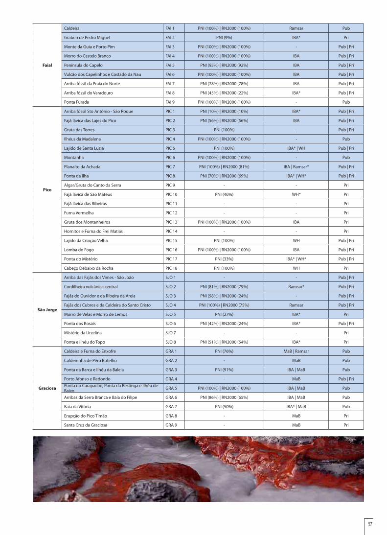
37
Faial
Caldeira FAI 1 PNI (100%) | RN2000 (100%) Ramsar Pub
Graben de Pedro Miguel FAI 2 PNI (9%) IBA* Pri
Monte da Guia e Porto Pim FAI 3 PNI (100%) | RN2000 (100%) - Pub | Pri
Morro do Castelo Branco FAI 4 PNI (100%) | RN2000 (100%) IBA Pub | Pri
Península do Capelo FAI 5 PNI (93%) | RN2000 (92%) IBA Pub | Pri
Vulcão dos Capelinhos e Costado da Nau FAI 6 PNI (100%) | RN2000 (100%) IBA Pub | Pri
Arriba fóssil da Praia do Norte FAI 7 PNI (78%) | RN2000 (78%) IBA Pub | Pri
Arriba fóssil do Varadouro FAI 8 PNI (45%) | RN2000 (22%) IBA* Pub | Pri
Ponta Furada FAI 9 PNI (100%) | RN2000 (100%) - Pub
Pico
Arriba fóssil Sto António - São Roque PIC 1 PNI (10%) | RN2000 (10%) IBA* Pub | Pri
Fajã lávica das Lajes do Pico PIC 2 PNI (56%) | RN2000 (56%) IBA Pub | Pri
Gruta das Torres PIC 3 PNI (100%) - Pub | Pri
Ilhéus da Madalena PIC 4 PNI (100%) | RN2000 (100%) - Pub
Lajido de Santa Luzia PIC 5 PNI (100%) IBA* | WH Pub | Pri
Montanha PIC 6 PNI (100%) | RN2000 (100%) - Pub
Planalto da Achada PIC 7 PNI (100%) | RN2000 (81%) IBA | Ramsar* Pub | Pri
Ponta da Ilha PIC 8 PNI (70%) | RN2000 (69%) IBA* | WH* Pub | Pri
Algar/Gruta do Canto da Serra PIC 9 - - Pri
Fajã lávica de São Mateus PIC 10 PNI (46%) WH* Pri
Fajã lávica das Ribeiras PIC 11 - - Pri
Furna Vermelha PIC 12 - - Pri
Gruta dos Montanheiros PIC 13 PNI (100%) | RN2000 (100%) IBA Pri
Hornitos e Furna do Frei Matias PIC 14 - - Pri
Lajido da Criação Velha PIC 15 PNI (100%) WH Pub | Pri
Lomba do Fogo PIC 16 PNI (100%) | RN2000 (100%) IBA Pub | Pri
Ponta do Mistério PIC 17 PNI (33%) IBA* | WH* Pub | Pri
Cabeço Debaixo da Rocha PIC 18 PNI (100%) WH Pri
São Jorge
Arriba das Fajãs dos Vimes - São João SJO 1 - - Pub | Pri
Cordilheira vulcânica central SJO 2 PNI (81%) | RN2000 (79%) Ramsar* Pub | Pri
Fajãs do Ouvidor e da Ribeira da Areia SJO 3 PNI (58%) | RN2000 (24%) - Pub | Pri
Fajãs dos Cubres e da Caldeira do Santo Cristo SJO 4 PNI (100%) | RN2000 (75%) Ramsar Pub | Pri
Morro de Velas e Morro de Lemos SJO 5 PNI (27%) IBA* Pri
Ponta dos Rosais SJO 6 PNI (42%) | RN2000 (24%) IBA* Pub | Pri
Mistério da Urzelina SJO 7 - - Pri
Ponta e ilhéu do Topo SJO 8 PNI (51%) | RN2000 (54%) IBA* Pri
Graciosa
Caldeira e Furna do Enxofre GRA 1 PNI (76%) MaB | Ramsar Pub
Caldeirinha de Pêro Botelho GRA 2 - MaB Pub
Ponta da Barca e Ilhéu da Baleia GRA 3 PNI (91%) IBA | MaB Pub
Porto Afonso e Redondo GRA 4 - MaB Pub | PriPonta do Carapacho, Ponta da Restinga e Ilhéu de Baixo GRA 5 PNI (100%) | RN2000 (100%) IBA | MaB Pub
Arribas da Serra Branca e Baía do Filipe GRA 6 PNI (86%) | RN2000 (65%) IBA | MaB Pub
Baía da Vitória GRA 7 PNI (50%) IBA* | MaB Pub
Erupção do Pico Timão GRA 8 - MaB Pri
Santa Cruz da Graciosa GRA 9 - MaB Pri

38
Terceira
Algar do Carvão TER 1 PNI (100%) | RN2000 (100%) Ramsar Pri
Caldeira de Santa Bárbara e Mistérios Negros TER 2 PNI (100%) | RN2000 (99%) - Pub | Pri
Caldeira de Guilherme Moniz TER 3 PNI (100%) | RN2000 (4%) - Pri
Furnas do Enxofre TER 4 PNI (100%) Ramsar Pub | Pri
Monte Brasil TER 5 - WH Pub | Pri
Pico Alto, Biscoito Rachado e Biscoito da Ferraria TER 6 PNI (100%) | RN2000 (84%) Ramsar Pub | Pri
Ponta da Serreta e escoadas traquíticas TER 7 PNI (100%) | RN2000 (69%) - Pub | Pri
Fajã da Alagoa - Biscoito das Calmeiras TER 8 PNI (8%) | RN2000 (8%) IBA* Pub | Pri
Graben das Lajes TER 9 - - Pri
Ilhéus das Cabras TER 10 PNI (100%) | RN2000 (100%) IBA Pri
Mistério 1761 e sistema cavernícola da Malha Grande - Balcões TER 11 PNI (61%) | RN2000 (44%) - Pri
Serra do Cume TER 12 - - Pub
Biscoitos - Matias Simão TER 13 PNI (74%) IBA* Pub
São Miguel
Caldeira do vulcão das Furnas SMG 1 PNI (100%) IBA* | Ramsar Pub | Pri
Caldeira do vulcão das Sete Cidades SMG 2 PNI (100%) Ramsar Pub | Pri
Caldeira do vulcão do Fogo SMG 3 PNI (100%) | RN2000 (100%) Ramsar Pub | Pri
Caldeira Velha SMG 4 PNI (100%) Ramsar Pub
Gruta do Carvão SMG 5 PNI (94%) - Pri
Ilhéu de Vila Franca SMG 6 PNI (100%) - Pub
Lagoas do Congro e dos Nenúfares SMG 7 PNI (100%) - Pub | Pri
Ponta da Ferraria e Pico das Camarinhas SMG 8 PNI (100%) IBA Pub | Pri
Serra Devassa SMG 9 PNI (100%) Ramsar Pub | Pri
Vale da Ribeira do Faial da Terra e Fajã do Calhau SMG 10 PNI (31%) IBA* Pri
Caldeira da Povoação SMG 11 PNI (44%) | RN2000 (4%) IBA* Pri
Coroa da Furna – Arrenquinha SMG 12 - - Pri
Fajã lávica e arriba fóssil da Caloura SMG 13 PNI (7%) | RN2000 (7%) - Pri
Fajã lávica e ilhéus dos Mosteiros SMG 14 PNI (11%) IBA* Pri
Morro das Capelas SMG 15 PNI (2%) - Pri
Morro de Sta Bárbara, praias e Bandejo SMG 16 - - Pub
Pico da Vara e Planalto dos Graminhais SMG 17 PNI (84%) | RN2000 (84%) IBA Pub | Pri
Pisão - Praia (Água d’Alto) SMG 18 - - Pub
Ponta do Cintrão - Ladeira da Velha SMG 19 PNI (9%) IBA* Pub | Pri
Praias do Pópulo, Milicias e São Roque SMG 20 - - Pub
Rocha da Relva SMG 21 - - Pri
Salto da Farinha SMG 22 - - Pub
Salto do Cabrito SMG 23 - - Pri
Vale da Ribeira Quente SMG 24 - - Pub | Pri
Vale das Lombadas SMG 25 PNI (100%) | RN2000 (69%) Ramsar Pub | Pri
Fontanário da Ribeira Seca SMG 26 - - Pub
Campo Geotérmico do Vulcão do Fogo SMG 27 PNI (88%) Ramsar Pri

39
Santa Maria
Barreiro da Faneca SMA 1 PNI (100%) - Pri
Pedreira do Campo SMA 2 PNI (100%) - Pub
Poço da Pedreira SMA 3 - - Pri
Ponta do Castelo SMA 4 PNI (100%) | RN2000 (100%) IBA* Pub | Pri
Ribeira do Maloás SMA 5 PNI (100%) | RN2000 (100%) IBA Pub
Baía da Cré SMA 6 PNI (64%) - Pub | Pri
Baía de São Lourenço SMA 7 PNI (84%) - Pri
Baía do Raposo SMA 8 PNI (100%) IBA Pub | Pri
Baía do Tagarete e Ponta do Norte SMA 9 PNI (100%) IBA Pub | Pri
Baía dos Cabrestantes SMA 10 - - Pub | Pri
Barreiro da Malbusca SMA 11 - - Pri
Cascata do Aveiro SMA 12 PNI (98%) IBA* Pub | Pri
Figueiral SMA 13 PNI (100%) - Pri
Porto de Vila do Porto SMA 14 - - Pub
Praia Formosa e Prainha SMA 15 PNI (22%) - Pri
Marine Areas
Banco D. João de Castro Marinha 1 RN2000 (7%) | PMA OSPAR Pub
Dorsal Atlântica e Campos hidrotermais Marinha 2 PMA OSPAR* Pub
Canal Faial-Pico Marinha 3 PNI (82%) | RN2000 (0,4%) OSPAR Pub
Ilhéus das Formigas e Recife Dollabarat Marinha 4 PNI (100%) | RN2000 (47%) OSPAR | Ramsar* Pub
Caption of Table 12:
Legal Protection
PNI Island Natural Park
PMA Azores Marine Park
RN2000 Natura 2000 Network
- Without Legal Protection
Other Classifications
IBA Important Bird Area
MaB Man and Biosphere Programme –Biosphere Reserves
OSPAR OSPAR Convention - Marine Protected Areas
Ramsar Ramsar Convention on Wetlands
WH UNESCO World Heritage
* Less than 50% of the geosite area
Land Owenership
Pub Mostly public areas
Pri Mostly private areasPub|Pri Public and private areas
Table 12 shows that 77% of the Azores geosites (93 geosites) are under legal protection of the Island Natural Parks, the Azores Marine Park and the Natura 2000 Network. From these, 52 geosites are integrated, simultaneously, in the Island Natural Parks and in the Natura 2000 Network, while 39 geosites are only under legal protection of the Island Natural Parks. One geosite, the D. João de Castro Bank, is integrated in the Natura 2000 Network and in the Azores Marine Park. Part of the Mid-Atlantic Ridge and its hydrothermal fields is also covered by the Azores Marine Park.
From the others 28 geosites, a significant number is covered by other classifications and protection and enhancement measures, like the geosites of Graciosa, Flores and Corvo islands, which are all integrated on the respective Biosphere Reserve. Therefore, only 19 geosites of the Azores don’t have any statute of legal protection (Table 12).
The Azores government has reformulated the legal regime of
the classification, management and administration of the Protected Areas of Azores, by the Regional Legislative Decree nr 15/2007/A, June 25th, considering the diversity of situations resulting from the implementation of the Natura 2000 Network in the Azores Autonomous Region and the need to adopt a management model that ensures the standardization of the several designations of the existent protected areas and that centralize competences in one territorial unit of the island as a management base. This diploma covers fundamental areas of nature conservation, that correspond to the most important areas in the point of view of conservation and of the biodiversity of the resources, and complementary ecological areas, which correspond to the main biophysics structures in the territory that allow the ongoing ecological processes between the fundamental areas and the territories that are the most inland and littoral territories, assuming a special role the hydric system in its superficial and subterranean components.

40
Following this reformulation, 9 Island Natural Parks and the Azores Marine Park were created, which constitutes the basic management units of the Regional Network of Protected Areas of the Azores. It should be mentioned that the Azores Marine Park includes marine protected sites that are located beyond the outer limit of the territorial sea, until the Exclusive Economic Zone.
Thus, the Regional Network of Protected Areas of the Azores Autonomous Region realizes in the Region the classification adopted by the International Union for Nature Conservation (IUCN), adapting it to the geographical, environmental, cultural and politico-administrative particularities of the Azores archipelago territory, having contemplated the following categories: a) Natural Reserve (Category I - IUCN); b) Natural Monument (Category III – IUCN); c) Protected Area for Habitats or Species Management (category IV – IUCN); d) Protected Landscape Area (Category V – IUCN); e) Protected Area for Resources Management (Category VI – IUCN).
The Island Natural Parks and the Azores Marine Park also include classified areas under the international directives and conventions, such as the areas of the Natura 2000 Network (with 23 Special Areas of Conservation, 15 Special Protection Areas and 2 Sites of Community Importance), 12 Ramsar sites, 12 OSPAR sites, 3 Biosphere Reserves and 1 UNESCO World Heritage area.
Considering the above mentioned Regional Legislative Decree, the Protected Areas of the Region were reclassified with uniformed criteria and, for the first time in the regional environmental legislation, the adopted classification has integrated elements of the Azores geology and geodiversity (in addition to those related to the biological component), in a perspective to ensure the integrity of the geological values and the related resources, by preserving remarkable geological, geomorphologic or speleological formations.
C3. Data on the management and maintenance of these sitesThe classification of the protected areas that integrate the Island Natural
Parks was especially directed towards the preservation of fauna, flora and natural habitats of the areas and their landscaping and geological value, as well as the promotion of the natural and cultural resources and values related to these areas. Concerning the politics and the strategies of geoconservation, the Regional Legislative Decree that create those natural parks explicitly aim for: i) the protection of the structural features of the landscape, the geological and geomorphologic elements or of the geologic outcrops; ii) the preservation of examples of the natural environment for scientific, monitoring and environmental public awareness purposes; iii) the conservation of natural reference conditions for the ongoing scientific works and projects; and iv) the definition of limits and constraints to unrestricted public access.
In addition, that legislation provides a set of interdict and conditioning acts in the protected areas, namely what regards the exploitation and the extraction of mineral masses and the setting of new geologic resources exploitation areas, the sampling, ownership and marketing of any geologic element or sample, the action of moving lands or changing the relief and vegetation cover and constructions that, by any way, may harm or destroy the surface or the interior of the protected volcanic caves (including the related speleothems), among others.
Considering the nature and the scope of the mentioned measures of protection and geoconservation, the interdictions and imposed conditionings and the preventive and improving actions that the Island Natural Parks cover, the management of the geosites which are under legal protection (91 geosites) will naturally be performed by the Regional Network of Protected Areas, with the contribution of the Azores Geopark Association in what concerns the geodiversity, geological heritage and geoconservation.
In the geosites with approved walking trails, the maintenance of the paths is ensured by the Azores Government, through the Environment and Sea Regional Secretariat and the Regional Directorate of Tourism, according to its own legislation.
In order to ensure the maintenance and to guarantee an effective management and protection of the natural and geologic heritage, some geosites have conditioned access and supervised visits, with load capacity defined in legislation and own Regulation, as it happens in the Caldera (Faial island), in Pico Mountain and in the volcanic caves.
C4. Listing and description of non-geological sites and how they are integrated into the proposed GeoparkSites of Environmental Interest
The Azores climate, geographic and geologic conditions are responsible for a major variety of biotopes, ecosystems and landscapes, which favor a high number of habitats and a significant diversity of species, some of them are endemic and have a high scientific, cultural and social value due to
its rarity. These features justify the different areas of Natura 2000 Network in the Region), whether under the Birds Directive (with the creation of 15 Special Protection Areas-SPA), whether in the Habitats Directive, with the creation of 23 Special Areas of Conservation (SAC) and 2 Sites of Community Importance (SCI).
The Azores Autonomous Region was pioneer in the elaboration of the Sectorial Plan of Natura 2000 Network, through the release of the Regional Legislative Decree nr 20/2006/A, June 6th, which is an instrument of accomplishment of the politics for the conservation of the biologic diversity, aiming for the protection and enhancement of the SPA and the SAC/SCI (adopted by the decision of the European Commission, of December 28th, 2001), so as the maintenance of the species in a favorable state of conservation.
There are innumerous wetland zones in the Azores, whether as coastal wetlands, with a marine influence (e.g. “Fajã da Calderia de Santo Cristo”, São Jorge island), whether as terrestrial wetlands, without a direct marine influence (e.g. lakes of Sete Cidades, São Miguel island). From the group of wetlands of the Region, 12 were officially named as Ramsar Sites, with a total area of approximately 13 thousand hectares. All this sites are part of the Regional Network of Protected Areas.
Under the OSPAR Convention of 1992, the instrument that guides the international cooperation in the protection of the marine environment of the Northeast Atlantic, 12 areas in the Azores have been classified, in their majority in close relation with the Mid-Atlantic Ridge and associated transform faults. The majority of these sites integrate the Azores Regional Network of Protected Areas, more specifically the Azores Marine Park.
All the sites of environmental interest mentioned above are managed by the Environment and Sea Regional Secretariat, through the Island Natural Parks. The necessary articulation with the geopark is ensured by the Director of the Island Natural Park, which represents the Azores Geopark on each island.
Sites Classified by UNESCO: World Heritage and Biosphere ReserveThe geopark territory includes two areas classified by UNESCO as World
Heritage: the Historical Centre of Angra do Heroísmo, Terceira island, and the Landscape of the Pico Island Vineyard Culture.
The classification of the Historical Centre of Angra do Heroísmo, obtained in 1983, recognizes the historical importance of this city from a political, economical, religious, geostrategic and military point of view. The relevance of the Angra bay, especially in the 15th and 16th centuries, and the importance of the city are portrayed in the renaissance urban structure of this city and its forts, unique examples of military architecture.
In 2004, the most representative and preserved parcel of the protected Landscape of the Pico Island Vineyard Culture was classified as World Heritage, covering an area of 987 hectares, surrounded by a tampon zone of 1934 hectares. This landscape is a square grid of basaltic stone walls, which impresses by its perfection and grandiosity and testifies the secular harmonious relationship between Man and Nature. Simultaneously to the vineyard culture, a diversified built heritage was being built, reflecting the experiences of the everyday life of a population dedicated to the hard work of viticulture. This activity provided exceptional quality wines, which have reached the four corners of the World and have played an important role in the economy of Pico island.
In the Azores archipelago three areas were classified as Biosphere Reserves, after approval by the UNESCO’s Bureau of the International Coordinating Council of the Programme MaB (Man and Biosphere): the Biosphere Reserves of Corvo island and Graciosa island (in 2007), and the Biosphere Reserve of Flores island, in 2009. In accordance to the objectives of the Programme Man and Biosphere, the management of these areas aims for a development model centered in the conservation and enhancement of the environmental and cultural heritages of those islands.
Sites of sociocultural interestOn the geopark territory there are different places that, due to its
features, functionality or historical past, have a significant cultural and sociocultural interest (Table 13). It is the case, among many others, of elements and sites related to whaling and the factories and infra-structures related to the local and handicraft products.

41
Sites of Civil, Military and Religious Architecture InterestThere are innumerous monuments, buildings or simple rural
sets of relevant civil, military, or religious architecture interest (Table 14) spread along all the islands.
Table 13 – Examples of sites of sociocultural interest in the Azores islands.
Sites of Sociocultural Interest Description Location Observations
Cooperativa Vitivinícola da Ilha do Pico
Wine production facilities, that commercializes wines produced on Pico, Graciosa and Terceira islands
Municipality of Madalena, Pico Island
Adega Cooperativa da Ilha Graciosa Municipality of Santa Cruz da Graciosa, Graciosa Island
Adega Cooperativa dos Biscoitos Municipality of Praia da Vitória, Terceira Island
Pineapples plantations
The production is made in greenhouses that preserverve the heat and the humidity. The antiquity , tradition and quality have contributed to the classification of the fruit with Designation of Origin (Pineaple of the Azores/São Miguel)
Municipalities of Ponta Delgada, Lagoa and Vila Franca do Campo, São Miguel Island.
Fábrica de Licores de Eduardo Ferreira & Filhos, Lda
It produces several liqueurs under the brands “Mulher de Capote” and “Ezequiel”.The Passion fruit Liqueur “Ezequiel” was distinguished and awarded with gold medals in many countries.
Municipality of Ribeira Grande, São Miguel Island
Tea
Plan
tati
ons Tea Factory of Porto
Formoso In São Miguel island there are the unique tea plantations with industrial purposes of Europe.
Municipality of Ribeira Grande, São Miguel Island
Tea Factory of Gorreana
União de Cooperativas Agrícolas e Lacticínios de São Jorge
Dairy industry facilities, that ensures the curing, classification and certification processes of the cow milk cheese produced on the island with international reputation.
Municipality of Velas, São Jorge Island
Horta marina
It is the most important marina of the Azores and the fourth most visited in the world. The walls are covered with paintings made by sailors.
Municipality of Horta, Faial Island
Helder of the European Blue Flag since 1987
Parque Arqueológico Subaquático da Baía de Angra do Heroísmo
This underwater archaeological park includes the shipwrecked steamship Lidador and the cast of iron anchors named “Anchors Cemetery”.
Angra do Heroísmo Bay, Terceira Island
Fábrica da Baleia do BoqueirãoIt is an industrial complex of cetacean processing, which stopped in 1981. Since 2009 it is a Centre of Environmental Interpretation.
Municipality of Santa Cruz das Flores, Flores Island
Building of public interest
Museu da Indústria Baleeira
It is a former industrial factory where sperm whales were processed. It is a testimony of the processing and production of vitamins, oils, flours and fertilizers.
Municipality of São Roque do Pico, Pico Island
Museu dos Baleeiros
The “Whalers Museum” settled in three boathouses has ethnographic objects representing the whale hunting and its history, and also Scrimshaw pieces.
Municipality of Lajes do Pico, Pico Island
Building of public interest
Scrimshaw museum
It is the biggest private collection of Scrimshaw Art (“Whaling Art”) in the World. There are useful and decorative pieces done in whale ivory and sperm whale bone.
Municipality of Horta, Faial Island

42
Sites of Civil Architecture Interest Description Location Observations
Vila do Corvo
The unique village of Corvo Island is a settlement of very concentrated housement, with an urban lay out structured by “canadas” (small roads), sometimes very narrow and labyrinthic.
Municipality of Vila do Corvo, Corvo Island Set of public Interest
Aldeia da Cuada
It is a country settlement of stony and winding paths, delimited by stone walls. Some buildings have been restored and adapted for rural tourism.
Municipality of Lajes das Flores, Flores Island Set of Municipal Interest
Aldeia do SanguinhoIt is an old abandoned settlement, currently in a recovery stage in order to became a touristic rural village.
Municipality of Povoação, São Miguel Island
Palácio dos Capitães Generais
This is a former Jesuit college, adapted to become the General Captain’s residence, in 1766. Nowadays it is the headquarter of the Regional Directorate of Organization and Public Administration.
Municipality of Angra do Heroísmo, Terceira Island
Building of public interest
Portas da Cidade
Built in 1783, this “City Gates” are defined by three round arches, exhibiting in the centre the Royal House and of the City coat of arms.
Municipality of Ponta Delgada, São Miguel Island
Building of public interest
“Impérios” of Terceira Island
All the parishes of the island have their own “império” (small chapel) of the Holy Spirit. These original monuments, of architectural and chromatic beauty, are often of popular inspiration.
Municipalities of Angra do Heroísmo and Praia da Vitória, Terceira Island
Windmills
Mills with lattice framework sails of Flemish influence and triangular sails of mainland Portugal influence. Dating back to late 19th century/early 20th century.
Municipality of Horta, Faial Island Building of public interest
Dutch style windmills, with red roofs and unfurled sails. They are the ex-libris of Graciosa island.
Municipality of Santa Cruz da Graciosa, Graciosa Island
Building of Municipal interest
Set of fixed windmills, with a conic-shaped body made of stone or plasted and whitewashed.
Municipality of Vila do Corvo, Corvo Island Building of Municipal interest
Sites of Military Architecture Interest Description Location Observations
Fortaleza de São João Baptista
This fort was built during the Spanish dominance of the territory (1580-1640) and, with about 4 km of defensive walls, it is considered the biggest fort ever built by Spain in the World.
Municipality of Angra do Heroísmo, Terceira Island
Building of public interest
Forte de Santa CruzDating to the 16th century, this fort was built to protect the city and the harbor of Horta. Currently, it is a Lodging House.
Municipality of Horta, Faial Island
Building of public interest, Regional Monument and National Monument
Forte de São Brás
Built during the 16th century to protect the harbor of Ponta Delgada, it is currently the headquarters of the Military Area and the Military Museum of the Azores.
Municipality of Ponta Delgada, San Miguel Island
Building of public interest
Sites of Religious Architecture Interest Description Location Observations
Chapel of “Nossa Senhora da Paz”
It is a temple of great beauty, dating to the 18th century. Is also one of the most privileged belvederes of the Region
Municipality of Vila Franca do Campo, São Miguel Island
Building of public interest

43
Botanical GardensIn several islands of the archipelago there are botanical
gardens and garden-like areas, some of them classified as Building of Public Interest and have acquired national and international
notoriety, as in the case of the “Parque Terra Nostra”, in Furnas, São Miguel island (Table 15).
Chapel of “Nossa Senhora das Vitórias”
Private Chapel built following a gothic style and a Romanesque inspiration, with stony ashlar. Located in the south margins of Furnas Lake.
Municipality of Povoação, São Miguel Island
Building of public interest
Church of “Nossa Senhora da Purificação”
It dates to the 16th century and in the 18th century it has been changed and enlarged. The front is Baroque, decorated with basalt ashlar.
Municipality of Vila do Porto, Santa Maria Island
Building of public interest
Church of “Santa Bárbara”
It dates to the 18th century and it is one of the most beautiful Azorean baroque examples. Its frontage is ornamented with basalt stone and its interior with wall tile panels painted with the life story of Saint Barbara.
Municipality of Velas, São Jorge Island
Building of public interest. National Monument
Church of “Colégio dos Jesuítas”
It is the church of devotion to All Saints and a baroque creation, built in the 16th century and rebuilt in the 17th century, time when the second and current frontage was made. Currently it is the Nucleus of Sacred Art of the Carlos Machado museum.
Municipality of Ponta Delgada, São Miguel Island
Building of public interest
Table 15 – Main botanical gardens of the Azores islands.
Sites Description Location Observations
Faial Island Botanical GardenAll the natural flora of the Azores is here gathered, from native and endemic to exotic plants, aromatic and medicinal and also a collection of orchids.
Municipality of Horta, Faial Island
“António Borges” Botanical Garden
Created by Azorean families, they became the greatest tourist attraction of the city in the 19th century, and still nowadays they are considered to be the richest and most beautiful botanical gardens of Ponta Delgada.
Municipality of Ponta Delgada, San Miguel Island
“José do Canto” Garden
Building of public interest; Building registered in the “Botanical Gardens Secretariat”
“Sant’Ana” Palace Garden
Building of public interest and Regional Monument
“Terra Nostra” Park
Bicentenary botanical garden which origin goes back to the year 1780. It has a ferriferous thermal water pool, little caves and gardens dedicated to various plant collections.
Municipality of Povoação, São Miguel Island
Considered, in 2007, by Condé Nast Travel Publications one of the 12 most beautiful gardens in the World

44
D - Economic Activity & Business PlanD1. Economic activity in the proposed Geopark
The Autonomous Region of Azores is distinguished by its unique characteristics in terms of landscape and natural resources, which offer great economic opportunities, particularly in the area of sustainable tourism and in the use of renewable energies, as well as in the promotion of the productive sectors of milk, meat, fishing and the traditional products and crafts.
In 2009, the Azorean Gross Domestic Product (GDP) amounts to 7 billion Euros (representing 2% of national GDP), noting a GDP per capita of 15123 Euros, 96% of national value. In 2008, and regarding the sectors composition of the Gross Value Added (GVA), 7.3% of the Azorean GVA focused on “Agriculture, Animal Production, Hunting and Sylviculture”, a value significantly higher than the weight that this sector represents in the national level, 2.4 %. The trade balance of the Azores presented, in 2007, a coverage rate of 52 %.
The Azorean business is very polarized, and in 2008 there was about 16,009 self-employed businessmen and 3,989 companies, and there was a large concentration of both classes on the São Miguel island, where 53% of the self-employed businessmen and 57% of the companies were located.
In the Autonomous Region of Azores there are productive sectors that deserve reference at the national level, particularly the sector of milk and dairy products, meat and fish. On the other hand, there is another set of activity sectors for which a high development potential has been projecting, for example in tourism, in organic and traditional production and renewable energies.
The dairy sector, and specifically the cow’s milk, has a strong presence in the Azorean economy: of the total production in Portugal, the Azores are contributing with 28.2%, and São Miguel island represents 63.4% of the total of the archipelago. Concerning the milk products, the production of cheese is the one that has greater expression and the production of yoghurts is the one that shows greater dynamism. It should be pointed out that the cheese produced in the Azores has represented, in 2010, 37% of the national production, and in this archipelago there are two cheeses with Protected Designation of Origin (PDO): the cheese of São Jorge and the cheese of Pico.
The sector of meat in the Azores is highly concentrated in beef, where the number of heads of cattle amounts to 245 thousands, 17.6 % of the national total, representing the dairy cows 40.4% of this total. The “Meat from the Azores” (“Carne dos Açores”) has a PDO designation.
The fishery sector represents 40% of the Azorean exportation (fish and canned tuna) and about 5% of employment. In 2009, fishery in the Azores represented 12.1% of the value of fish at a national level and 6.5% of the national volume of fish.
The traditional products and crafts have been achieving an increasing economic importance in the Region, which is reflected in significant business opportunities. The production of tea, honey, pineapple and passion fruit are some examples. The diversity and richness of the Azorean flora contribute to the achievement of high-quality honey, and there are two types: the honey of centrifuged nectar (colorless to yellow) obtained mainly from the nectar of incense and the multiflora honey (dark brown). In Portugal there are nine protected names of honey, one of which is the “Honey of the Azores” (“Mel dos Açores”).
The cultivation of tea is located just on São Miguel island, where the only two plantations of tea in Europe for industrial purposes - the tea Gorreana and the tea Porto Formoso - ensure an annual production of around 100 tones.
In 2006, orange and banana trees occupied the main agricultural area of fruit crops, with 42.9% and 30.6%, respectively. There are two agriculture products with a PDO designation: the “Pineapple from the Azores” (“Ananás dos Açores”) and the “Passion Fruit of São Miguel” (“Maracujá de São Miguel”). The pineapple has an average annual production of 1.9 thousand tones and it is produced in about 450 farms, while the passion fruit began to be
sold in 2003 by three farms, with a total production of two tones.Due to orographic nature and the climatic conditions in the
Azores, the culture of the wine develops mainly in farms of small size; however this production has been increasing. There are three regions that produce “Quality Wine Produced in a Specified Region”, which represent 9.3% of the production of white wines in the Azorean wine-growing region: the region of Pico, the region of Graciosa and the region of Biscoitos/Terceira island.
The Azores have plentiful renewable energy resources, and indeed they have been pioneers, at a national level, in the exploitation of hydroelectric, wind and wave energy. The production of electricity from Renewable Energy Sources represents approximately 27.9% of the total electricity production, of which 79% was from geothermal sources. Investments in renewable energy are predicted by 2015, which will achieve around 112.5 million Euros and will represent an increase of 108.7% of the capacity currently installed.
According to the Tourism Satellite Account of the Azores, the tourism sector (including tourism and the indirect effects generated by the sector) represents 11.5% of the Azorean GDP, an amount comparable with the national value, of 8.8%. In what concerns GVA, the Azorean tourism represents a weight of 5.5% (4.7% at a national level). The “Hotels and Similar Establishments” are those who contribute the most to the GVA of the Azorean tourism, with a weight which amounts to 27.1%. In 2010, the number of guests who have visited the Azores amounted to about 348 thousand (of whom 61.5% national) and the income of lodgings amounted to 35.3 million of Euros, 3% of the national total.
D2. Existing and planned facilities for the proposed GeoparkThe Azores Geopark territory includes several infrastructures
and centers of environmental interpretation, scientific dissemination and promotion of natural heritage, in general, and of the geological heritage, in particular. Among these infrastructures it is worth mentioning the Centers of Environmental Interpretation managed by AZORINA and the Regional Network of Science Centers of the Azores, operated and driven by Regional Secretariat of Science, Technology and Equipments (SRCTE) in close conjunction with several institutions and entities of the Azores.
The Centers of Environmental Interpretation (Table 16) are educational and exhibition poles associated to a protected area and they aim at informing visitors and tourists about the natural and cultural values of the area, through an accessible, modern and interactive language. These centers of interpretation are relevant infrastructures to the activities and the projection of the geopark, which is achieved with an articulated management and with team-sharing (cf. Table 6).
The Science Centers (Table 17) are spaces for the dissemination of scientific and technological culture, which aimed at promoting contact between the school reality and the world of science, supporting the implementation of the experimental teaching and facilitating the access of all citizens to the new information and communication technologies. The GEOAÇORES Association, the SRCTE secretariat and the entities responsible for the management of these science centers share objectives, interests and actions, which improve these infrastructures in the context of the Azores Geopark and which are expressed in a memorandum of collaboration.
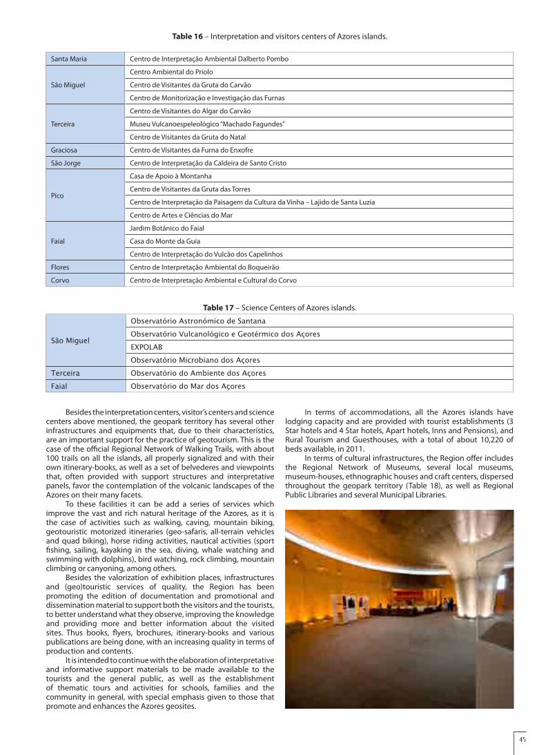
45
Besides the interpretation centers, visitor’s centers and science centers above mentioned, the geopark territory has several other infrastructures and equipments that, due to their characteristics, are an important support for the practice of geotourism. This is the case of the official Regional Network of Walking Trails, with about 100 trails on all the islands, all properly signalized and with their own itinerary-books, as well as a set of belvederes and viewpoints that, often provided with support structures and interpretative panels, favor the contemplation of the volcanic landscapes of the Azores on their many facets.
To these facilities it can be add a series of services which improve the vast and rich natural heritage of the Azores, as it is the case of activities such as walking, caving, mountain biking, geotouristic motorized itineraries (geo-safaris, all-terrain vehicles and quad biking), horse riding activities, nautical activities (sport fishing, sailing, kayaking in the sea, diving, whale watching and swimming with dolphins), bird watching, rock climbing, mountain climbing or canyoning, among others.
Besides the valorization of exhibition places, infrastructures and (geo)touristic services of quality, the Region has been promoting the edition of documentation and promotional and dissemination material to support both the visitors and the tourists, to better understand what they observe, improving the knowledge and providing more and better information about the visited sites. Thus books, flyers, brochures, itinerary-books and various publications are being done, with an increasing quality in terms of production and contents.
It is intended to continue with the elaboration of interpretative and informative support materials to be made available to the tourists and the general public, as well as the establishment of thematic tours and activities for schools, families and the community in general, with special emphasis given to those that promote and enhances the Azores geosites.
In terms of accommodations, all the Azores islands have lodging capacity and are provided with tourist establishments (3 Star hotels and 4 Star hotels, Apart hotels, Inns and Pensions), and Rural Tourism and Guesthouses, with a total of about 10,220 of beds available, in 2011.
In terms of cultural infrastructures, the Region offer includes the Regional Network of Museums, several local museums, museum-houses, ethnographic houses and craft centers, dispersed throughout the geopark territory (Table 18), as well as Regional Public Libraries and several Municipal Libraries.
Table 16 – Interpretation and visitors centers of Azores islands.
Santa Maria Centro de Interpretação Ambiental Dalberto Pombo
São Miguel
Centro Ambiental do Priolo
Centro de Visitantes da Gruta do Carvão
Centro de Monitorização e Investigação das Furnas
Terceira
Centro de Visitantes do Algar do Carvão
Museu Vulcanoespeleológico “Machado Fagundes”
Centro de Visitantes da Gruta do Natal
Graciosa Centro de Visitantes da Furna do Enxofre
São Jorge Centro de Interpretação da Caldeira de Santo Cristo
Pico
Casa de Apoio à Montanha
Centro de Visitantes da Gruta das Torres
Centro de Interpretação da Paisagem da Cultura da Vinha – Lajido de Santa Luzia
Centro de Artes e Ciências do Mar
Faial
Jardim Botânico do Faial
Casa do Monte da Guia
Centro de Interpretação do Vulcão dos Capelinhos
Flores Centro de Interpretação Ambiental do Boqueirão
Corvo Centro de Interpretação Ambiental e Cultural do Corvo
Table 17 – Science Centers of Azores islands.
São Miguel
Observatório Astronómico de SantanaObservatório Vulcanológico e Geotérmico dos AçoresEXPOLABObservatório Microbiano dos Açores
Terceira Observatório do Ambiente dos AçoresFaial Observatório do Mar dos Açores

46
In the Azores islands there are several infrastructures to support tourism, such as tourist offices and kiosks of tourist information, located particularly at airports and major urban and tourist centers of the Region.
At an educational level, several activities for schools and the population in general take place on the archipelago, which, together with the environmental education and awareness, promote the geological heritage, the conservation of nature and the waste problem, among others. Recently, it was implemented the Regional Plan for Environmental Awareness and Education of the Azores, that defines a medium-term strategy for these activities, involving the Regional Network of “Ecotecas”, schools, non-governmental organizations for the environment, associations and parishes. The GEOAÇORES Association, within the strategic partnership established with AZORINA, participates in this program, which aims at implementing a model of sustainable development in the territory. This participation includes the development of interactive educational programs for students and teachers, study visits and informative and scientific dissemination actions target to the general public, such as those included in the program “Science Activities in the summer”.
D3. Analysis of geotourism potential of the proposed GeoparkThe rare Nature and its natural and geological heritage are,
without doubt, the main ex-libris of the Azores, with scenic and aesthetic characteristics and attributes of great attractiveness and geotouristic potential.
Traditionally, the visitors of the Azores are looking for the volcanic landscapes and the surrounding sea for mere contemplation, enjoyment or for the practice of different activities in the unique natural environment that the Azores offer. The Nature Tourism, tourist product defined as strategic for the Azores within the National Strategic Plan for Tourism, is one of the main tourist
products of the Region and is, without doubt, the main component of the Azorean tourist industry.
The volcanic landscapes of the Azores are, thus, the main motto of interest and development of geotourism in the archipelago and they present a wide range of possibilities for sustainable use, where several activities can be performed and associated tourist products can be developed, such as walking and geotourism.
The secondary manifestations of volcanism existing in several islands have a high interest and potential in the Health and Well-being Tourism area, taking advantage of baths in thermal waters of recognized therapeutic properties, the intake of carbonated and mineral waters and the use of mud as peloides due to their medicinal properties. The gastronomy cooked in the steam of the fumarolic field of the Furnas Lake typifies another typical geo-product of the Azores.
The promotion of geotouristic itineraries in urban centers, taking advantage, for example, of the ashlar stone of military fortifications, manor houses, monasteries and churches, improves the understanding of the local history as well as the use of raw materials and geological resources. It is also possible to associate the geology of certain places with the settlement and development of urban areas, as well as their toponymy. There are also places and ruins that can be visited which eyewitness the occurrence of natural geological phenomena, such as volcanic eruptions and earthquakes.
The geotourism in the Azores has several offers and complementary products, namely in Gastronomy, built and cultural heritage and in nautical, radical, bird-watching and whale-watching activities.
The geotourism strategies in the Azores Geopark are supported on the exploitation, maximization and organization of the existing services and tourist infrastructures, taking profit of the available resources and enhancing joint synergies. For this purpose,
Santa Maria Museu de Santa Maria
São Miguel
Museu Carlos Machado
Museu Etnográfico do Nordeste
Museu da Olaria
Casa Museu Armando Cortes Rodrigues
Casa Museu Natália Correia
Museu Casa do Arcano
Museu do Trigo
Terceira
Museu de Angra do Heroísmo
Museu do Vinho
Casa Museu Francisco E. de O. Martins
Graciosa Museu da Graciosa
São Jorge Museu Francisco de Lacerda
Pico
Museu dos Baleeiros
Museu da Indústria Baleeira
Museu do Vinho
Faial
Museu de Arte Sacra
Museu da Horta
Casa Etnográfica de Cedros
Flores Museu das Flores
Table 18 – Main museological infrastructures of the Azores islands.

47
partnerships with several stakeholders have been set up, such as with the associations responsible for promoting the Azores as a tourist destination and for the qualification of the tourism offer in the Region (e.g. the Tourism Association of the Azores-ATA and the Regional Association of Tourism-ART). This is done bearing in mind that the implementation of the geotourism requires proper planning to consolidate and develop itself with guarantees of success.
The global strategy of sustainable tourism in the Azores has been successful and its implementation has seen recognized, as is evidenced by several national and international prizes and rewards. In 2007, the National Geographic Traveler magazine considered the archipelago as the second best islands in the world for sustainable tourism. In 2008, the publisher Lonely Planet indicated the Region as one of the best destinations worldwide and in 2010 the Forbes magazine distinguished the Azores as “One of the world’s most unique travel destinations“. In this same year, the Sete Cidades Lake and the Volcanic Landscape of Pico Island were considered two of the “7 Natural Wonders of Portugal”, by public voting integrated in the initiative of the New Seven Wonders Portugal. In the year 2011, those prizes included the classification: (ii) of the Azores, by the National Geographic Traveler, as one of ten best destinations worldwide for summer; (ii) of the walking trail of the Vineyards of Criação Velha, on Pico island, by the BootsnALL, as one of the eight best trails of the World; (iii) of Furnas, on São Miguel island, by the World Travel Guide, as one of the five more appealing volcanic areas in the world, and (iv) of Pico island, by the BBC Travel, as one of the five best secret islands in the world.
Still in 2011, the AMRAA - Association of the Azorean Municipalities received the Prize “Geoconservation 2011”, attributed by ProGEO Portugal and the Faial Island Natural Park received the EDEN Prize and was confirmed by the European Commission as the first European Destination of Excellence in Portugal.
D4. Overview and policies for the sustainable developmentThe Azores Geopark aims to stand-up has a territory that
combines the protection and valorization of its geological heritage with the sustainable development of their communities, in the socio-economic, educational, environmental and cultural point of view. In this context, the balanced and sustainable economic development of the Azores assumes a good articulation between the management of tourism and the implementation of policies of geoconservation that ensure the promotion of the geotourism (e.g. of the volcano tourism) as a touristic product of recognized excellence, quality and reputation. The implementation and further consolidation of the Azores Geopark and its integration into the European Geoparks Network will certainly help to achieve this desideratum and is a strategic purpose of the Azores Regional Government for the current legislature.
This purpose, integrated into a wider vision to promote sustainable tourism and a tourism that respects the environmental values of the Azores, is supported by various strategic and planning documents, among which there are:
• The Azores Autonomous Region Tourism Plan, which defines the strategy for the sustainable development of the tourism sector and the territorial model to adopt. The options of this document are based on the binomial nature/landscape and the respect for the nature conservation, environmental quality, preservation of historical and cultural heritage, quality of touristic products and the identity and differentiation of the tourist offer.
• The Azores Strategic Marketing Plan, which is aimed to promote the Region in key markets (e.g. active tourism and well-being tourism), giving priority to the peculiarities of each island and considering the potential of the archipelago in European and worldwide terms. This document presents a geotouristic proposal based, i) in the development of intra and inter-island routes and, (ii) in the existence of promotional measures complemented by monitoring actions. Among the routes to implement it can be pointed out the Volcanic Caves, the Belvederes, the Walking Trails, the Thermal Spas and Science Centers routes.
• The Central Group Strategic Plan for the Tourist Animation,
which has as its main purpose the promotion of the sustainable development of tourism in the five islands of the Central Group of the archipelago based on the endogenous resources and the respect for the natural and cultural heritage, with focus on tourist animation. This plan has as its main areas of intervention the nature tourism and sports, the nautical tourism activities, the touring and cultural animation, the meeting industry and the health and well-being.
On the other hand, the creation, in 2010, of the AZORINA, S.A. - Society of Environmental Management and Nature Conservation, S.A. is another important step in this global strategy, taking into account the mission and objectives of this society, which include (i) the valorization of the natural and landscape resources and the biodiversity and geodiversity of the Azores archipelago, and (ii) the public participation and the involvement of citizens in information actions and awareness and environmental education, namely those integrated in the Regional Network of “Ecotecas”, centers of environmental interpretation and similar structures.
Nevertheless, the sustainable use of the territory enhanced by the Azores Geopark will, necessarily, impose some constraints and limitations to the activities to develop in certain parts of the territory, that it is important to identify, study and monitor in due time.
D4.1. Overview and policies for the sustainable development of geo-tourism and economy
The various houses of rural tourism and tourist animation companies existing in the Azores already offer a wide range of experience within Geotourism, which include walking trails, geotours and speleological activities, among others.
Several local products can be considered as true “geo-products”, as in the case of the wines that use names such as “Terras de Lava” (“Lava Lands”), “Basalto” (“Basalt”), “Magma” or “Pedras Brancas” (“White Stones”), many of which produced in Pico island, a Quality Wine Produced in a Specified Region and Cultural Heritage of Humanity region. The greatest exponent of this relationship and the true ex-libris of the Azorean geo-products is “Cozido das Furnas”, a typical Portuguese gastronomic recipe cooked slowly, for about 5 hours, by the steam of the fumarolic field of Furnas Lake, in a pot buried in the thermal andosoil.
In the territory of the geopark various theme routes are implemented, including the Volcanoes Route, the Whaling Activity Route, the Cheese Route and the Wine Route that, being organized by the Azores geopark partners, involve public entities and local companies on the areas of catering, crafts, heritage (natural, cultural and architectonical) and animation. The same is true for the “Cultural Route of the Azores - Antero de Quental”, as routes planned in well signposted itineraries, allowing to the visitor and tourist a pre-established route and organizing the tourist and cultural offer related to the proposed theme.
Keeping intact its identity and a strong bond to the nature and the Azorean culture, the handicraft from the Azores has innovated and built a current speech, based in the rich historical past of the Azores and in their ancestral traditions, which have become a reference in the arts and crafts. The handicraft of the Azores uses elementary materials, such as wood, fish scales, whale bones and teeth, the corn leaf, clay, basalt and pumice. The certification mark “Artesanato dos Açores” (“Crafts of the Azores”) includes “Bordados dos Açores” (“Embroidery of the Azores”), “Rendas dos Açores” (“Lace of the Azores”), “Tecelagem dos Açores” (“Weaving of the Azores”), “Miolo de Figueira dos Açores” (“Fig Tree Pith of the Azores”), “Registos do Senhor Santo Cristo dos Milagres” (“Records of the Senhor Santo Cristo dos Milagres”), “Escama de Peixe” (“Fish Scales”) and “Bolos Lêvedos”. Other local products are in the process of certification, such as traditional pastry and some dishes of the regional gastronomy.
D4.2. Overview and policies for the sustainable development of geo-education
Within the Educational Programs of the Azores Geopark, it was programmed a set of activities adjusted to the schools curricula and designed for the different students, from kindergarten to the

48
secondary school. These activities, which will be implemented in all the islands, are executed in collaboration with the Island Natural Parks and AZORINA, S.A., partners of the project in what concerns the Environmental Education and Awareness, and they improve the approach of geo-education in an inter-disciplinary perspective.
In fact, these activities complement actions carried out in several other fields, from waste management issues and biodiversity to wetland zones, focusing now on the geodiversity, geological heritage and geoconservation themes. These actions include:
• The availability of online contents in the site of the geopark, under the themes “Azorean volcanoes” and “Azorean Geolandscapes”, adapted to different school levels. The contents to make available include a PowerPoint, a script to the teacher, worksheets, suggestions of activities and programs for the field trip “Geosites of My Island”;
• Promotion of the activity “Litoteca da Minha Ilha” (“Rock Collection of My Island”), promoting visits to the sites where outcrop the different types of rocks of the island, its photography or illustration and the execution of other similar works that discourage the collection of samples and propitiate the existence of a collection of rocks (“litoteca”) in the school;
• The development of the theme “Geology in Our Village/Town”, enhancing the characterization of geology in built heritage, the typologies of stones used in construction, the use of the Portuguese cobblestone pavement (“calçada portuguesa”), etc.;
• Carrying out recycling and training courses on geo-environmental interpretation for technicians of the Island Natural Parks and the AZORINA S.A., guides, tourism technicians, teachers and other professionals with specific interests in these sectors.
The integration of these activities in the Regional Plan of Awareness and Environmental Education of the Azores and in the activities of the Regional Network of “Ecotecas”, centers of environmental interpretation, science centers and similar structures will ensure: (i) a broad thematic scope of the educative actions, (ii) their effectiveness and, (iii) the complete dissemination among the target audiences of the different islands of the Azores.
In 2011 and in partnership with several entities (National Commission of UNESCO, Environment and Sea Regional Secretariat, Regional Secretariat of Education and Training, Regional Secretariat of Agriculture and Forestry and the Regional Directorate of Youth), the Azores Geopark has promoted a school contest called “Natural Resources for Sustainability”, with the subtopic “Azores Geopark”, aiming at raising awareness among students and the entire educational community to the importance of the geopark; 226 students and 42 teachers from 13 schools in the Region have participated, and have produced posters, models and audiovisual material.
D4.3. Overview and policies for the sustainable development of geo-heritage
The politics of sustainable development in the Azores are based on the stimulation of activities that promote the economic development of the territory (in particular of the less developed parcels), taking advantage of the endogenous resources of the Azores, including their natural resources. The later includes the valorization of elements of the Azorean geodiversity (such as their geolandscapes) and of the Azores geological heritage (as the volcanic caves). This valorization presumes a reasonable usufruct of this heritage, aiming at ensuring its sustainability in the short, medium and long term.
However, there is still a long way to go in the Region in what concerns the definition of management policies of the sites of geological interest that promote its protection and assure its conservation and valorization. As a priority, a greater involvement and participation of the local communities must be achieved, since they are the true means of promotion of the local development, being able to create employment, improve the economy and promote the mitigation of the environmental impact and socioeconomic problems, and, thus, contributing to
the preservation of the natural heritage for present and future generations.
The use of the thermal resources of the archipelago, including those associated to “Termas do Carapacho”, on Graciosa island, and “Termas da Ferraria”, on São Miguel island, is a perfect example of the implementation of policies for the valorization of the endogenous resources of the Azores, aiming for the promotion of the economic development of the territory. In the Carapacho Thermal SPA, the therapeutic qualities of its waters, at temperatures around 40ºC, are known for a long time and can be enjoyed in a modern Thermal Bath building, properly equipped. In Ponta da Ferraria Thermal SPA, along with a modern Thermal Bath that rehabilitated a building of the early 20th century, the users may enjoy thalassotherapy in a natural pool of sea-water heated by a thermal spring at about 60ºC, in an unique geological landscape of the archipelago. The “Poça da Dona Beija” thermal spring, in Furnas, and the “Caldeira Velha” thermal spring, in Ribeira Grande are other favorite spots to enjoy the countless Azorean thermal facilities and to fell and appreciate the strength of the Azores volcanism.
Among the 250 volcanic caves existing in the Azores, it is worth mentioning, for its outstanding, geological importance and heritage value, the “Algar do Carvão” (Terceira island), the “Gruta das Torres” (Pico island), the “Furna do Enxofre” (Graciosa island), the “Gruta do Carvão” (São Miguel island) and the “Gruta do Natal” (Terceira island). Open to the public during the whole year and following a model of supervised visits, these volcanic caves allow to the visitor an experience of entering and walking inside a volcano, at the same time that he discovers points of interest and curiosities about the genesis and characteristics of these underground worlds.
The dormant volcano of Pico Mountain, the highest point of Portugal and the third biggest volcanic edifice of the North Atlantic, rises majestically 2351 m above the sea-level and dominates the volcanic landscape of Pico island, challenging the most adventurous to climb uphill.
In the Azores archipelago there are manifestations of faith and religious devotion closely related to the occurrence of catastrophic natural phenomena, especially the volcanic and seismic phenomena that often affect these islands. One that stands out is the Holy Spirit Festivities in the Azores, which dates back to early settlement and constitute a genuine demonstration of popular culture of the Azorean people, where the profane is often mixed with the sacred and the mundane pleasures of the good gastronomy cohabitates with promises made to the Divine.
With a less territorial expression, but not less important, other festivities take on a symbolism and relevance to note. They are: i) the “Império dos Nobres” (“The Nobles Empire”), on Faial island that, evoking the 1672 eruption of the Cabeço do Fogo volcano, is associated to the perpetual vow that orders to celebrate a solemn ceremony on the day of Pentecost ; ii) the secular vote of the City Council of Horta in honor of “Senhor Santo Cristo dos Milagres” of Praia do Almoxarife village, dating back to 1718, following the volcanic eruption occurred on the neighbor Pico island and which frightened the population of Faial; iii) the “Procissão dos Abalos” (“Earthquakes Procession”), on Terceira island, which is held every year on May 31st, in evocation of the intense seismic activity that occurred on the night of June 1st to June 2nd, 1867, premonitory of the submarine eruption offshore “Ponta do Raminho”, the place overlooking the sea where is celebrated an outdoor Mass and Sermon, and iv) the “Romeiros da Ilha de São Miguel” (“São Miguel island Pilgrims”), a group of men who travel on foot across the whole São Miguel island by the time of Lenten, in prayer and penance, a tradition dating back to the 16th century when the island was shaken by a violent earthquake that decimate the population and caused severe damages.
D5. Policies for, and examples of, community empowerment (involvement and consultation) in the proposed Geopark
The Azores Geopark has developed a wide range of actions in order to ensure the participation of the local communities in this project. This actions included, i) the participation in festivals and cultural traditions of highly popular expression, explaining to the local communities the link between the geology and the events; ii) the promotion of information and dissemination public meetings

49
on all the islands and assigned to all the community; iii) the realization of thematic workshops; iv) the participation in fairs and seminars; v) the organization of thematic contests and exhibitions, like the school contests “Natural Resources for Sustainability” and “Geo-paintings”, with the exhibition, in several places, of the works produced; vi) the production and publication of the geopark information and dissemination materials, namely the website, social networks (such as facebook), a periodic newsletter, flyers, Geosites maps, postcards, information panels and thematic brochures, and vii) the promotion of the geopark through the Mass Media, namely in television, radio and newspapers.
It is also important to mention the participation in the Project “Citizenship and Sustainability for the 21st Century: Roads for a Sustainable Community in the Azores”, promoted by the National Council for Education and the Luso-American Foundation for the Development of the Azores, in cooperation with several Regional and Local entities, as a contribution to the development of the Regional School Curricula and for the teacher training in the field of Geosciences.
The territory of the geopark integrates also the Project “Route of Mines and Sites of Mining and Geological Interest in Portugal”, managed by the General Directorate of Energy and Geology (of the Ministry of Economy, Innovation and Development of Portugal) and the Mining Development Company S.A., and in joint cooperation with several national partners.
D6. Policies for, and examples of, public and stakeholder awareness in the proposed Geopark
Since the beginning of its activities, in mid 2008, the staff team of the Azores Geopark has taken part of several national and international events and forums dedicated to the geological heritage, conservation, geotourism and geoparks themes, reporting the work done and sharing experiences and training. In addition, the participation in congresses and other scientific meetings, workshops, work meetings and intensive courses and
the visit to some geoparks of the European and Global Geoparks Networks have proved to be essential for the consolidation of the project and the present application.
Since the beginning, the staff team counted on the support and close collaboration of the Portuguese geoparks (Naturtejo and Arouca), of the National Commission of UNESCO and of the ProGEO Portugal, whose involvement, knowledge and share of information have been extremely useful.
In the initial stage of the works, there have been several meetings involving the Regional Government, Azores University, Association of the Azorean Municipalities, Local Actions Groups, Tourism Associations, National Comission of UNESCO and the Portuguese Geoparks (Naturtejo and Arouca), with the aim of providing information about the project and its potentialities to the possible geopark partners, as well as debating the most adequate management model for the geopark. Following those meetings, the current management model was defined as well as the partners who would integrate the Association as founding members.
In a second step, these meetings have been extended not only to the decision takers of the territory in different areas of interest to the geopark, but also to several associations, enterprises and other public and private entities, from which resulted the set of partnerships already established and those to come. These partnerships and the memoranda of collaboration which supports them, improves the sharing of means and resources, aggregate synergies and ensure a more effective management of the discontinuous territory of the geopark.
In all the process involving the creation of the geopark it was promoted an effective involvement of the school communities and the general population, through public debates or sessions on every island, the presence on the Mass Media and the availability of diverse information regarding geoparks. For that dissemination purpose, the ICT, and in particular the Internet and the geoparks own site, have been the privileged mean of information.

50
E – Interest and arguments for joining the EGN/GGN
The geopark now proposed is located in a region that is a true natural laboratory for geology, geomorphology, volcanology and many other scientific areas, such as, seismology, oceanography and climatology. From here result the production of countless scientific and research works about the Azores, including master’s and doctoral theses, books, papers in national and international scientific journals and the participation and organization of scientific meetings and congresses. The scientific importance of the Azores is of particular relevance at the aim of the Earth Sciences, given its peculiar global geodynamic framework, active volcanism, volcanic landscapes and neotectonics.
The international relevance of the geological heritage of the territory, its scientific, scenic and educational value and, simultaneously, the existence of a rich biodiversity and a remarkable cultural heritage, are the foundations for the implementation in the territory of sustainable development policies, strongly supported in environmental protection strategies, in general and in geoconservation, in particular. Bearing in mind this framework, the Azores Government considered the creation and implementation of the Azores Geopark as a structuring project for the Region and included this desideratum in its program for the period of 2008-2012.
The integration of the Azores Geopark in the European Geoparks Network will strengthen the links between geology, volcanic landscapes, biodiversity and cultural values, including
the Azorean Man. This holistic and integrative view will improve synergies and serve as an additional incentive for all intervenient in the project, including the partners of the geopark, schools, businesses and investors, in particular of the tourism sector and local artisans and producers, among others.
The cooperation and networking within the European and Global Geoparks Networks will allow the exchange of experience and knowledge, promoting the implementation of new dynamics and processes that can contribute to the continuous improvement of the Azores Geopark management.
The possibility of using the brand “European Geoparks Network”, sponsored by UNESCO, is a strong argument and motivation for this application, since it will recognize the Azores archipelago as a region of quality and excellence and that guides itself by internationally known principles of exigency and notoriety. This brand will also reinforce the notoriety of the unique geodiversity and geological heritage of the Azores, serving a strategy of sustained development of the communities based, namely, on geotourism and on nature tourism, and the promotion of an economic growth of the territory with respect for its environmental values.
With the motto “9 islands – 1 Geopark”, this application presents itself as pioneering, as it will be the first truly archipelagic territory: all the 9 islands are part of the geopark, are inhabited and have infrastructures and services that ensure the development of the activities of the geopark. Additionally, the geographic localization of the Azores, between the European and American continents, makes this Atlantic territory a true “bridge between two continents”!

51